Burnt Hill
Burnt Hill is a hamlet in Berkshire, England. It is situated just north of the M4 motorway in West Berkshire and is in the civil parish of Yattendon (where according to the Grid Ref the 2011 Census population was mostly included), which is also the closest village, and lies in the North Wessex Downs area of outstanding natural beauty (AONB) .
Burnt Hill seems to have been established as a brick making settlement in the 18th century and there were several brick works in the area in the 18th and 19th centuries. Burnt Hill probably takes its name from the glow in the night sky from the firing of bricks. In 1703 one Isaac Jeram is recorded as working in bricks at Burnt Hill.[1] In the south east of the village is Kiln Pond and, as its name suggests, this was probably a source of clay for the brick making.
Burnt Hill is surrounded by fields of the Yattendon Estate, many of Christmas trees, for which the estate is well known and Burnt Hill Common of mixed woodland. There was a convoy camp stationed at Burnt Hill Common during World War 2 and concrete foundations of many of the building can still be found in amongst the trees.
Combined Ashampstead and Burnt Hill Commons are 80 hectares of mixed woodland. Until the mid 13th century the Commons were pasture woodland. Subsequently they were enclosed to form a deer park with a substantial bank and inner ditch that can still be traced for some 5.5 km.[2]
The main street around which most of the village is arranged is unedifyingly named Scratchface Lane probably referring to the narrow, bramble strewn track it once was.
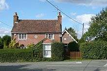
There are some notable buildings in Burnt Hill including the Methodist Chapel 1864 which is still in use, Burnt Hill House, Burnt Hill Cottage, Wistaria Cottage (now very much extended), Sloe Pightle (pightle a small field or enclosure presumably where sloes grew) and Nut & Bolt House formerly the Axe and Compass Public House (aka The Compasses Inn). The Axe and Compass changed its name to the Nut & Bolt Public House in the 1970s (reputedly after the licensees of the time; John and Val Bolton [3] ) According to the West Berkshire Campaign for Real Ale when the Boltons were asked why they changed the name they said,‘Because we are the Bolts and all our customers are nuts!’ [4] It is now called Nut & Bolt House, a private house.
Nut & Bolt House has two dated bricks in its front facade circa 1834 and 1873 but was a public house from at least 1817[5] when it was mentioned in the trial of one William Fuller for "stealing, on the 22d of April , one gelding, price 20£.; one mare, price 20£., the property of Edward Shepherd ; and one coat, value 15s. , the property of Thomas Shepherd" a farmer and his son at nearby Yattendon. John Hope, an acquaintance of the defendant, testified "On the 21st of April, I saw him at the sign of the Compasses, at Burnt-hill, which is about a mile from Mr. Shepherd's; he left there about a quarter after six in the evening." Fuller was found guilty and sentenced to death aged 22.
Later the Axe and Compass was probably a butcher too when it was licensed to a William Larkcom [6](b 1809 d 10 July 1891 at the Axe and Compass), After Williams' death it was licensed to his daughter Elizabeth.[7] By 1924 it was still in the Larkcom family having been taken over by Elizabeth's brother another William.[8]
Other licensees followed Chas Prince from at least 1928 to 1931 [9] and William George Alsbury from at least 1964 to 1971 [10] (Clearly there are others.)
Opposite Nut & Bolt House is the curiously named The Bungalow; curious because it is not a bungalow. Prior to ~2010 it had the far more interesting name of Compass Pightle providing a link between Axe and Compass and the use of artisan tools as names and symbols and Sloe Pightle and the now archaic use of the word pightle as a small field or clearing. Hopefully the plot will be restored to its original name in the future.
By 1830 in reaction to the introduction of mechanisation to agriculture the South of England erupted in what became known as the Swing Riots. Disturbances started in nearby Yattendon and on 21 November a hard core of rioters met at the Axe and Compass, Burnt Hill. After a night at the pub they acquired a sledge hammer and a horn and at first light set off to local farms to extort money and smash threshing machines, later returning to the Axe and Compass before setting off again at nightfall to other farms in the area. By the early hours of 24 November the troops arrived and arrested eleven of the rioters although none was eventually charged.[11]
At the time of the 1851 religious census, the Primitive Methodists were holding Sunday services in a cottage at Burnt Hill, which was not used exclusively for religious worship. It attracted a congregation of forty. The census return for that Sunday was signed by a local preacher, George Merritt, who lived in Burnt Hill and was an agricultural labourer.[12]
In 1864 the Methodist chapel was built and named Zion. It contains a portrait of the well-known and widely influential Primitive Methodist minister, Isaac Nullis, born nearby at Ashampstead in 1828. Zion is still in use as a Methodist chapel two Sundays a month.
Nearby towns
Nearby villages
References
- ↑ In the Valley of the Pang, Dick Greenaway and Dorcas Ward
- ↑ In the Valley of the Pang, Dick Greenaway and Dorcas Ward
- ↑ Pub Names of Britain, Leslie Dunkling and Gordon Wright
- ↑ http://www.westberkscamra.org.uk/quiz_answers.pdf
- ↑ Old Bailey Proceedings, 21st May 1817
- ↑ Kelly’s Directory 1848 and 1887
- ↑ Kelly’s Directory 1899, 1907 and 1915
- ↑ Kelly’s Directory 1920 and 1924
- ↑ Kelly’s Directory 1928 and 1931
- ↑ The London Gazette 05-Jun-64 and 22-Apr-71
- ↑ Basildon, Berkshire An Illustrated History, Clive Williams
- ↑ http://www.myprimitivemethodists.org.uk/page_id__440_path__0p9p72p.aspx
Coordinates: 51°27′54″N 1°11′02″W / 51.4649°N 1.1838°W