M4 motorway
| |
|---|---|
_map.svg.png) | |
| Route information | |
|
Part of | |
| Maintained by Highways England and the South Wales Trunk Road Agency | |
| Length: | 191.9 mi (308.8 km) |
| Existed: | 1961 – present |
| History: | Constructed 1961–96 |
| Major junctions | |
| From: |
Chiswick 51°29′23″N 0°16′41″W / 51.4897°N 0.2781°W |
|
M25 motorway A308(M) motorway A404(M) motorway A329(M) motorway M32 motorway M5 motorway M48 motorway M49 motorway M48 motorway A48(M) motorway | |
| To: |
Pont Abraham services 51°44′42″N 4°03′54″W / 51.7451°N 4.0651°W |
| Location | |
| Primary destinations: |
London Heathrow Slough Maidenhead Bracknell Reading Newbury Swindon Chippenham Bristol Newport Cardiff Bridgend Port Talbot Neath Swansea Llanelli |
| Road network | |

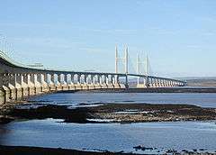
The M4 is a motorway which runs between London and South Wales in the United Kingdom. Major towns and cities along the route include Slough, Reading, Swindon, Bristol, Newport, Cardiff and Swansea. Originally referred to as the London-South Wales Motorway, the English section, including a suspension bridge over the River Severn, was constructed between 1965 and 1971; the Welsh element was completed in 1993. A new Severn bridge, known as the Second Severn Crossing, was opened in 1996 with the M4 rerouted to use it.
The M4 runs close to the A4 from London to Bristol. After crossing the River Severn it follows the A48 through South Wales, using the Brynglas Tunnels at Junction 25a, Newport and terminates just north of Pontarddulais. It is one of only three motorways in Wales; the other two, the A48(M) and M48, branch off it. The area of land along the M4, with its towns and cities, is known as the M4 corridor. European route E30 includes most of the M4, although it is not signed as such.
History
A new road from London to South Wales was first proposed in the 1930s, and the Ministry of Transport announced plans for the M4 as one of the first major post-war trunk road improvement projects in 1956.[1]
The Chiswick flyover, a short section of elevated dual-carriageway built to reduce the impact of traffic travelling between central London and the west, opened in 1959;[2] it was not originally classed as a motorway.[3] The Maidenhead bypass opened in 1961 whilst J1-J5 opened in 1965. The stretch from J18 to the west of Newport was opened in 1966, including the Severn Bridge (now part of the M48). The Port Talbot by-pass, also built in the 1960s and now part of the M4, was originally the A48(M) motorway, a number now allocated to a short section of motorway near Cardiff. The Ministry of Transport originally intended that the M4 would terminate at Tredegar Park west of Newport, and it was only following the creation of the Welsh Office that the Government became committed to a high-standard dual carriageway to Pont Abraham in Carmarthenshire.[4]
The English section of the motorway was completed on 22 December 1971 when the 50-mile (80 km) stretch between Junctions 9 and 15 (Maidenhead and Swindon) was opened to traffic.[5] The Welsh section was completed in 1993, when the Briton Ferry motorway bridge opened. The Second Severn Crossing opened in 1996, together with new link motorways on either side of the estuary to divert the M4 over the new crossing. The existing route over the Severn Bridge was redesignated the M48, and the new M49 was opened to connect the new crossing to the M5.[6]
In June 1999 the section of the third lane (the lane nearest the central reservation) between Junctions 2 and 3 was converted to a bus lane, first as a pilot scheme and then permanently in 2001. A lower speed limit was introduced along the bus lane section at the same time[7] (the lane was however reverted to general traffic use by the incoming coalition government in late 2010).[8]
In April 2005 speed checks carried out by police camera vans between Junction 14 and Junction 18 led to a public protest, involving a "go-slow" of several hundred vehicles along the affected sections of the motorway.[9]
Between 2007 and January 2010 the section from Castleton (Junction 29) to Coryton (Junction 32) was widened to six lanes.[10] The scheme was formally opened on 25 January 2010 by Ieuan Wyn Jones the Deputy First Minister for Wales.
During 2009 the Newport section of the motorway between Junctions 23a and 29 was upgraded with a new concrete central barrier. In February 2010 it was proposed that the M4 in South Wales would become the first hydrogen highway with hydrogen stations provided along the route, with an aspiration for further stations to be provided along the M4 into South West England over time.[11] A similar claim was made for a 30-mile (48 km) section of road in Scotland close to Aberdeen in September 2009 with refuelling points at Bridge of Don, Ellon and Peterhead.[12]
In October 2010 the new Secretary of State for Transport, Philip Hammond, announced that the bus lane in the London section would be suspended for 18 months from 24 December 2010, be brought back into use temporarily for the 2012 Summer Olympics, and then be removed.[13]
Between 2008 and 2010, Junction 11, near Reading, was extensively remodelled with a new four-lane motorway junction, two new road bridges and other works.[14] The £65m scheme included work on the Mereoak roundabout and part of the A33 Swallowfield Bypass near Shinfield, and also the conversion of the two existing bridges, one of which is available only to pedestrians and cyclists and the other to buses.[15] It also involved the movement of the local Highways Agency and Fire Service offices, and the construction of a long footbridge network, a new bus-lane and a new gyratory. Sound barriers for nearby residential areas were also installed.[16] In April 2008, the decision to preserve a rare Vickers machine gun pillbox and turn it into a bat roost was announced by the developers.[17]
The table below shows the timeline for the construction of the motorway on a section by section basis.[18][19][20][21][22][23]
| Year opened | 1961 | 1963 | 1965 | 1966 | 1967 | 1971 | 1972 | 1977 | 1980 | 1994 |
|---|---|---|---|---|---|---|---|---|---|---|
| Section(s) | J7–9 | J5–7 | J1–5 | J18–23 J39–41 | J22–28 | J9–18 | J44–46 | J28–29 J32–35 J37–39 J46–49 | J29–32 J35–37 | J41–44 |
Note: When the Second Severn Crossing was opened in 1996 the M4 was re-routed to cross the new bridge; the previous section of motorway between Junctions 21 to 23 was renamed the M48.[24]
Features
Toll bridge
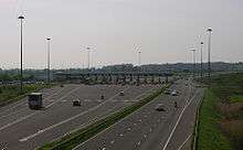
The M4 crosses the River Severn via a toll bridge, the last of only three on the UK motorway network – the first was the original Severn Bridge, now part of the M48 and the second is the Queen Elizabeth II Bridge, part of the Dartford Crossing. Tolls are charged in one direction only: westbound. Drivers therefore have to pay to enter Wales, but not to enter England.
Speed limits
For the majority of its length, the national speed limit applies. Exceptions include the following:
- 40 miles per hour (64 km/h) on the Chiswick Flyover within London in both directions.
- 60 miles per hour (97 km/h) between Junction 4 and the Chiswick Flyover eastbound only.
- 50 miles per hour (80 km/h) when approaching the toll plaza after leaving the Severn Crossing, to protect plaza staff moving between the toll booths.[25]
- 50 miles per hour (80 km/h) on the Port Talbot elevated section between Junction 40 and Junction 41. The fixed speed camera was removed in 2006 as it was believed to cause tailbacks – it was replaced with an average speed camera system, installed in July 2014. It generates around £500,000 in fines each six months.[26][27]
M4 bus lane

Between 1999 and 2010 there was a controversial 3.5-mile (5.6 km) bus lane on the eastbound (London-bound) carriageway from Junction 3 (A312) to the western end of the Chiswick Flyover near Brentford, covering part of the 15-mile (24 km) journey between Heathrow Airport and central London. The lane which had no intermediate exits was for use by buses, coaches, motorcycles, emergency vehicles and licensed taxis but not mini-cabs.[28] It was used by 7% of vehicles which carried 21% of the people.[7]
The lane was restored for normal motorway running at the end of 2010 for 18 months[8] using an Experimental Traffic Order[29] and was re-established for the duration of the 2012 Summer Olympics with the intention that it would then be removed permanently.[8]
Porous road surface
Near Junction 35 of the M4, there is a stretch of the motorway that has a surfacing of porous asphalt that improves drainage and reduces noise. When driving in heavy rain drivers notice a reduction in road spray from other vehicles and improved visibility. This special surface was publicised in an episode of the BBC's Tomorrow's World programme. This was the site of the first trial of the new road surface when it was laid down in 1993.[30]
Elevated and heated section
The elevated section of the M4 in West London, built in the 1960s, is mostly directly above the A4 and extends over parts of Brentford's Golden Mile. This section was designed to have a heated road surface to reduce icing in winter.[31][32]
Four level stack interchanges
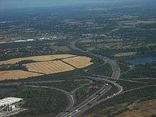
The M4 has two of only three four-level stack interchanges in the UK, including the first UK example at the junction with the M5 (Junction 20/"Almondsbury Interchange") and the other at the junction with the M25 (J4b). Junction 4b also has to make provision for a railway line passing beneath the M4. Due to the nature of such junctions, it is impossible to make a u-turn at Junction 20 or Junction 4b.
Smart (managed) motorway
The M4 motorway has two sections of smart motorway between Junctions 19 (M32) and 20 (M5) north of Bristol, and between Junction 24 and Junction 29 north of Newport. The section between Junctions 19 and 20 have variable speed limits and a part-time hard-shoulder and was completed in early summer 2014.[33] The section between Junctions 24 and 29 only has variable speed limits. It was designed save money through fewer accidents in the long term. Widening this section of the motorway is not possible because of the two-lane Brynglas Tunnels and existing housing close to the motorway.[34]
Tunnels
The M4 passes through the Brynglas Tunnels at Junction 25a, Newport. These are the only twin–bored tunnels on the United Kingdom motorway network.
Notable junctions
Junction 8/9 at Maidenhead, Berkshire, is the only one in the UK with dual numbers. This a relic from when the M4 used to turn north after junction 8, where it met the A308, and head for the original Junction 9, where it ended on a roundabout interchange with the A4. When the westward extension was opened junction 8 was closed and a new junction built a little to the west, taking both numbers. The road to the A4 became A423(M) and later A404(M) and the junction with the A4 became 9B. Junction 9A is the exit for Cox Green and White Waltham. West of Junction 13 on the eastbound carriageway there are a set of sliproads signposted "Works Unit Only". The signs have red borders, implying a military exit. It is a back entrance to RAF Welford, a Second World War airfield and now an RAF/USAF military installation mainly used for storing munitions. The M4 entrance allows easier access for the large vehicles used to carry the munitions.[35]
The section of the M4 in South Wales has to thread its way through mountainous terrain and built-up areas, so there are some unusual junction layouts. Junction 27 (High Cross) is a normal grade-separated roundabout junction, but subject to severe space constraints: traffic joining the motorway must initially travel in the opposite direction to the intended direction of travel, before making a sharp left-hand turn from the slip road onto the motorway. Junctions 30–31 (East Cardiff) were set aside for intermediate additional interchanges at the time of construction. Junction 30 (Cardiff Gate) has since been added but there are no current plans to construct Junction 31 (A469 road). Junction 39 can only be used to access the motorway from a single slip road onto the westbound carriageway from the A48 at Junction 38. There is no exit from the motorway at this junction.[36]
Junction 41 comprises two different junctions, one for traffic to and from local destinations to the west and one for places to the east. The former leads to and from a spur leading to the roundabout in Briton Ferry, formerly known as Junction 41a, and the original bridge over the River Neath, which would allow access onto the stretch of the M4 from Junction 43 westward. The second, eastern junction leads to and from the A48 towards Port Talbot. As a result, it is possible in both directions to travel almost 2 miles (3.2 km) on the motorway, both joining and then leaving the motorway at "Junction 41".[37] Junction 44 is unusual in that the eastbound entrance dives under the inside of the junction, effectively a creating a "right-turn" on a roundabout. Similarly, slip roads pass under or over the main motorway at Junctions 41 and 42.
Maintenance
Maintenance of the section of the motorway within England, some 123 miles (198 km), is the responsibility of the Highways Agency.[38] The section within Wales, some 76 miles (122 km), is the responsibility of the Welsh Government.[39]
Proposed developments
Hard shoulder running, from Junction 3 to Junction 12
In 2010 it was announced that hard shoulder running would be introduced from Junction 3 to Junction 12.[40] As of January 2012 no further information is available on the Highways Agency Website other than mention of the scheme on the main map showing the network and proposed works where it is proposed that work will start 'post 2015'.[41][42][43]
New junctions: 15a, 18a
A new Junction 15a, being considered by Wiltshire Council, this would give access to South and Central Swindon as well as to Wroughton, Marlborough and Devizes via the existing A4361, as well as a possible Junction 18a which would connect with the A432 and A4174 giving better access to Bristol, via Mangotsfield, and also a direct link with Yate.[44]
M4 Junction 31
Plans for the "missing" Junction 31, also known as the Thornhill interchange, for which planning permission was originally granted in September 1991 (but subsequently expired), were rekindled after proposals for a new business park on a 125 acres (51 ha) site north of the M4 were submitted in 2007 to Cardiff Council.[45] The developers of the business park, St Modwen Developments, would likely fund the new junction, which would be on the A469.[46]
A freedom of information request in 2010 to Cardiff Council shows that whilst the land that would enable this junction should continue to be strategically protected, the decision to formally abandon the proposed Junction 31 Thornhill was made in October 2007 and there had been no subsequent mention of it in Cardiff Council Strategic or Planning meetings since.[47]
M4 relief road around Newport
Plans for an 'M4 Relief Road' around Newport were first announced by the Welsh Office in 1991, but made little progress. The Welsh Assembly Government revived the scheme as the M4 relief road tolled bypass in 2007 but later abandoned it for financial reasons.[48] An extension to the Newport Southern Distributor Road through the old Corus steel works is being considered.[49] This road is already a dual carriageway but not open to the public. A public consultation exercise on options for improving the capacity of the M4 corridor around Newport opened on 5 March 2012. Its website states that:[50] "the motorway around Newport does not conform to today’s motorway standards. It lacks continuous hard shoulders, has closely spaced junctions with sub-standard slip road visibility and narrows to a restricted two lane section through the Brynglas Tunnels. Heavy congestion occurs along this stretch and either side of it at peak hours."
Port Talbot, Junctions 40 and 41
There have been calls to close the slip roads at Junction 40 and 41 (at Port Talbot) to improve traffic flow. The motorway has only two lanes on this stretch and is a major traffic congestion blackspot. Junctions 40 and 41 (at Port Talbot) have very short slip roads which have not been modernised.[51] The Port Talbot peripheral distributor road is under development, which should divert local traffic away from the M4.
Incidents and accidents
- In June 1984 a crash near Maidenhead resulted in 13 deaths.[52]
- In March 1991 ten people died in a series of crashes in 1991 involving 51 vehicles near Hungerford.[52]
- In May 1995 a coach carrying Royal British Legion members left the road close to the Severn Bridge, resulting in 10 deaths.[52]
- In April 1998, drummer Cozy Powell died following a car accident on the M4 near Bristol.
- In July 2002, Gus Dudgeon, a music producer known for his work with Elton John, and his wife died when the car he was driving veered off the M4 between Reading and Maidenhead. The inquest recorded a verdict of accidental death.[53]
- In July 2011 a lorry fire in the Brynglas Tunnels closed the motorway.[54] Although there were no injuries and no deaths, one tunnel remained closed and a contraflow system was in place in the remaining tunnel for about one month, causing major travel delays.[55][56]
Junctions
| M4 motorway | |||||
| mile | km | Eastbound exits (B carriageway) | Junction | Westbound exits (A carriageway) | |
|---|---|---|---|---|---|
| 7.3 | 11.8 | Road continues as A4 to Central London | J1 [coord 1] |
Start of motorway | |
| 8.3 8.5 |
13.4 13.7 |
North Circular A406 South Circular A205 Chiswick A315 |
J2 | Staines, Hounslow, Brentford A4 | |
| 12.5 12.8 |
20.1 20.6 |
Heston services | Services | Heston services | |
| 13.4 13.7 |
21.5 22.1 |
Heathrow |
J3 | Heathrow | |
| 15.2 15.7 |
24.5 25.2 |
Heathrow Uxbridge A408 |
J4a | Heathrow Uxbridge A408 | |
| 16.8 17.7 |
27.0 28.5 |
Heathrow (Terminals 4, 5 & Cargo) |
J4b [coord 2] |
Heathrow (Terminals 4, 5&Cargo), Gatwick, Watford (M3), (M23), (M40), (M1), M25 | |
| 19.1 19.5 |
30.7 31.4 |
Colnbrook, Langley, Slough (East) A4 Eton, Datchet B470 |
J5 | Colnbrook, Langley, Slough (East) A4, Datchet B470 | |
| 22.9 23.2 |
36.8 37.4 |
Slough (Central) A355 Windsor A322 |
J6 | Slough (Central) A355 Windsor A322 | |
| 24.7 25.0 |
39.8 40.3 |
Slough (West) A4 | J7 | Slough (West) A4 | |
| 27.8 28.2 |
44.7 45.4 |
High Wycombe, Henley A404(M) Maidenhead A308(M) |
J8/9 | High Wycombe, Henley A404(M) Maidenhead A308(M) | |
| 35.0 35.8 |
56.4 57.6 |
Reading (East), Wokingham, Bracknell A329(M) | J10 | Reading (East), Wokingham, Bracknell A329(M) | |
| 40.6 41.2 |
65.4 66.3 |
Basingstoke, Reading (Central & South) A33 | J11 | Basingstoke, Reading (Central & South) A33 | |
| 43.5 43.8 |
70.0 70.5 |
Reading services | Services | Reading services | |
| 45.3 45.7 |
72.9 73.5 |
Reading (West), Theale A4 | J12 | Reading (West), Theale A4 | |
| 56.9 57.2 |
91.5 92.1 |
Newbury, Oxford A34 Chieveley services (Moto) |
J13 Services [coord 3] |
Newbury, Oxford A34 Chieveley services (Moto) | |
| 64.4 64.8 |
103.7 104.3 |
Hungerford, Wantage A338 | J14 | Hungerford, Wantage A338 | |
| 68.7 | 110.5 | Membury services | Services | Membury services | |
| 76.4 77.1 |
122.9 124.0 |
Swindon (East) A419 Marlborough A346 Oxford (A420) |
J15 | Swindon A419, Marlborough A346 | |
| 82.4 82.8 |
132.6 133.2 |
Swindon (West), Royal Wootton Bassett, Wroughton, RAF Lyneham, Calne A3102 | J16 | Swindon (West), Royal Wootton Bassett, Wroughton, RAF Lyneham, Calne A3102 | |
| 94.8 95.3 |
152.5 153.4 |
Chippenham A350 Cirencester A429 |
J17 | Chippenham A350 Cirencester A429 | |
| 96.7 | 155.7 | Leigh Delamere services | Services | Leigh Delamere services | |
| 104.9 105.6 |
168.8 170.0 |
Bath, Stroud A46 | J18 | Bath, Stroud A46 | |
| 112.8 113.2 |
181.5 182.1 |
Bristol M32 | J19 | Bristol M32 | |
| 115.8 116.3 |
186.3 187.2 |
The SOUTH WEST, Bristol (West), The MIDLANDS, Gloucester M5 | J20 Almondsbury Interchange [coord 4] |
The SOUTH WEST, Bristol (West) M5(S) The MIDLANDS, Gloucester M5(N) | |
| 117.7 189.5 |
189.5 190.0 |
No access | J21 | Chepstow M48 | |
| 121.3 121.6 |
195.2 195.7 |
Avonmouth M49 | J22 | Avonmouth M49 | |
| 121.7 124.1 |
195.9 199.8 |
Entry into England | Second Severn Crossing [coord 5] |
Entry into Wales | |
| 127.0 | 204.4 | No toll plaza | Bridge Toll | Toll plaza | |
| 129.2 | 208.0 | Chepstow M48 | J23 | No access | |
| 131.4 132.2 |
211.4 212.8 |
Magor, Caldicot A4810 Magor services |
J23A Services |
Magor, Caldicot A4810 Magor services | |
| 134.8 135.6 |
217.0 218.3 |
City centre A48 Newport (East) B4237 Monmouth A449 The MIDLANDS (M50) |
J24 | City centre A48 Newport (East) B4237 Monmouth A449 | |
| 137.9 | 222.0 | No access | J25 | Caerleon B4596 | |
| 138.3 | 222.6 | No access | J25A | Newport, Cwmbran A4042 | |
| 138.8 139.1 |
223.4 223.8 |
Brynglas Tunnels | Tunnel | Brynglas Tunnels | |
| 139.1 139.5 |
223.8 224.5 |
Newport, Cwmbran, Caerleon A4051 | J26 | Newport A4051 | |
| 140.8 141,4 |
226.6 227.6 |
High Cross B4591 | J27 | High Cross B4591 | |
| 142.0 142.9 |
228.5 230.0 |
Newport A48 Risca, Brynmawr A467 |
J28 | Newport A48 Risca, Brynmawr A467 | |
| 143.6 | 231.1 | No access | J29 | Cardiff (East and South) A48(M) | |
| 146.6 147.3 |
236.0 237.0 |
Cardiff (East) A4232 Cardiff Gate services |
J30 Services |
Cardiff (East) A4232 Cardiff Gate services | |
| 151.9 244.5 |
244.5 246.1 |
Merthyr Tydfil, Cardiff A470 | J32 | Cardiff (North), Merthyr Tydfil A470 | |
| 155.4 156.0 |
250.1 251.1 |
Cardiff (West), Barry, Penarth A4232 Cardiff Airport Cardiff West services |
J33 Services |
Cardiff (West), Barry, Penarth A4232 Cardiff Airport Cardiff West services | |
| 157.5 158.1 |
253.5 254.4 |
Llantrisant, Rhondda A4119 Royal Glamorgan Hospital |
J34 | Llantrisant, Rhondda A4119 Royal Glamorgan Hospital | |
| 163.9 164.4 |
263.7 264.5 |
Pen-coed A473 | J35 | Bridgend, Pen-coed A473 | |
| 167.5 168.3 |
269.6 270.8 |
Bridgend A4061 Maesteg A4063 Princess of Wales Hospital Sarn Park services |
J36 Services |
Bridgend A4061 Maesteg A4063 Princess of Wales Hospital Sarn Park services | |
| 172.8 173.5 |
278.1 279.3 |
Pyle, Porthcawl A4229 | J37 | Porthcawl, Pyle A4229 | |
| 177.0 177.3 |
284.9 285.3 |
Port Talbot A48 | J38 | Port Talbot A48 | |
| 178.3 | 286.9 | No access (on-ramp only) | J39 | No access | |
| 179.7 179.9 |
289.2 289.6 |
Port Talbot A4107 | J40 | Port Talbot A4107 | |
| 180.9 181.3 |
291.1 291.8 |
Port Talbot A48 | J41 | Briton Ferry A48 | |
| 183.9 184.9 |
295.9 297.3 |
Briton Ferry A48 Swansea (South) A483 |
J42 | Swansea (South) A483 | |
| 184.9 185.7 |
297.5 298.8 |
Neath, Merthyr Tydfil A465 | J43 | Neath, Merthyr Tydfil A465 | |
| 187.0 187.4 |
300.9 301.6 |
Swansea (East) A48 | J44 | Swansea (East) A48 | |
| 188.8 189.3 |
303.9 304.7 |
Pontardawe, Swansea (North) A4067 | J45 | Pontardawe, Swansea (North) A4067 | |
| 190.8 191.4 |
307.0 308.0 |
Llangyfelach B4489 Felindre Morriston Hospital |
J46 | Llangyfelach B4489 Felindre Morriston Hospital | |
| 192.4 193.1 |
309.6 310.7 |
Swansea (West) A483 Gorseinon A48 Swansea services |
J47 Services |
Swansea (West) A483 Gorseinon A48 Swansea services | |
| 196.4 197.1 |
316.0 317.2 |
Pontarddulais, Llanelli A4138 | J48 | Pontarddulais, Llanelli A4138 | |
| 199.2 | 320.6 | Start of motorway | J49 Terminus Services [coord 6] |
Motorway terminates at a roundabout: Carmarthen A48 Ammanford, Llandeilo A483 Pontarddulais A48 Pont Abraham services | |
| Data[57][58][59][60] from driver location signs and location marker posts are used to provide distance and carriageway identification information. Where a junction spans several hundred metres and the data is available, both the start and finish values for the junction are shown. | |||||
| 1.000 mi = 1.609 km; 1.000 km = 0.621 mi | |||||
- Coordinate list
- ↑ 51°29′22″N 0°16′40″W / 51.48944°N 0.27778°W Eastern end of M4
- ↑ 51°29′41″N 0°29′44″W / 51.49472°N 0.49556°W Intersection of M25 and M4
- ↑ 51°27′14″N 1°18′52″W / 51.45389°N 1.31444°W Intersection of M4 and A34(E05)
- ↑ 51°33′01″N 2°33′11″W / 51.55028°N 2.55306°W Almondsbury Interchange – Intersection of M4 and M5
- ↑ 51°34′21″N 2°41′31″W / 51.57250°N 2.69194°W Second Severn Crossing
- ↑ 51°44′42″N 4°03′54″W / 51.74500°N 4.06500°W Western end of M4
See also
References
- ↑ "The M4 London to South Wales Motorway. Holyport to Tormarton". The Motorway Archive Trust. Retrieved 3 October 2010.
- ↑ Curtis, Nick (1 October 2009). "The 'sweet little Chiswick Flyover' hits 50". This Is London. Retrieved 3 March 2012.
The showbiz opening on 30 September 1959 was therefore a shrewd publicity stunt by Alderton's managing director, J E Dayton. It worked.
- ↑ "THE OLDEST MOTORWAY". The Motorway Archive Trust. Archived from the original on 22 January 2010. Retrieved 3 March 2012.
- ↑ "The M4 in Wales". The Motorway Archive Trust. Retrieved 1 October 2010.
- ↑ "On the road". The Motor. nbr 3625: Page 30. 23 December 1971.
- ↑ "The Motorway Archive: M4 Second Severn Crossing". Iht.org. 28 April 1992. Retrieved 31 December 2011.
- 1 2 "Does this look like a U-turn?". BBC. 18 January 2001. Retrieved 12 May 2010.
- 1 2 3 "Stretch of M4 bus lane opens to all motorists". BBC News. 16 November 2010. Retrieved 16 November 2010.
- ↑ "Drivers hold M4 speed camera demo". BBC News. 30 April 2005.
- ↑ ": : M4 Motorway Widening : :". web.archive.org. Archived from the original on 15 January 2008. Retrieved 20 November 2010.
- ↑ "M4 in Wales to be 'hydrogen highway,' ministers to say". BBC News. 12 February 2010. Retrieved 12 February 2010.
- ↑ Fraser, Douglas (8 September 2009). "'Hydrogen highway' plans backed". BBC News. Retrieved 12 February 2010.
- ↑ "Government to scrap M4 bus lane". BBC News. 1 October 2010. Retrieved 1 October 2010.
The controversial M4 bus lane is due to be scrapped at the end of the year. Under the plans, all motorists will be able to use the 3.5 miles (5.6 km) lane which operates on the London-bound carriageway from near Heathrow
- ↑ "M4 Junction 11 Improvement Scheme". Highways Agency.
- ↑ "M4 Junction 11 Improvements". Reading Borough Council.
- ↑ "Reading is the fastest-growing economic centre in UK". Reading Chronicle. 10 July 2007.
- ↑ "M4 VICKERS MACHINE GUN PILLBOX, PILLBOX STUDY GROUP". Pillbox-study-group.org.uk. 11 April 2008. Retrieved 31 December 2011.
- ↑ "Dates:M4. Chiswick to Slough By-pass (J1 to J5)". The Motorway Archive Trust. Retrieved 13 March 2013.
- ↑ "Dates:M4 Slough-Maidenhead By-pass (Junctions 5 to 7) Statistics and options". The Motorway Archive Trust. Retrieved 13 March 2013.
- ↑ "Dates:M4. Maidenhead to Wickham (J8 to J14) Statistics and options". The Motorway Archive Trust. Retrieved 13 March 2013.
- ↑ "Dates:The Aust (J21) to Wickham (J14) section of M4 Statistics and options". The Motorway Archive Trust. Retrieved 13 March 2013.
- ↑ "Dates:M4 in Wales Statistics and options". The Motorway Archive Trust. Retrieved 13 March 2013.
- ↑ "History Overview". Severn River Crossing Plc. 2011. Retrieved 16 March 2013.
- ↑ "Second Severn Crossing, England and Wales – Halcrow Group". Halcrow.com. 29 October 2009. Retrieved 16 March 2013.
- ↑ "Speed cameras slow bridge traffic". BBC News. 5 October 2004.
- ↑ "Average speed cameras for Port Talbot M4 stretch". BBC South West Wales. 14 July 2014. Retrieved 14 July 2014.
- ↑ "M4 speed cameras generate half a million pounds". itv.com. 2015-06-16. Retrieved 2016-03-05.
- ↑ Edwards, Tom (11 September 2009). "M4 bus lane is 'barely enforced'". BBC News. Retrieved 12 May 2010.
- ↑ "Work starts to remove M4 Bus Lane". Highways Agency.
The suspension of the M4 Bus Lane is being carried out under an Experimental Order under the Road Traffic Regulation Act 1984
- ↑ "2006 Fourth quarter foundation magazine – Operations and products" (PDF). Hanson.biz. 31 May 2011. Retrieved 31 December 2011.
- ↑ "One More Link to the West". New Scientist: 772. 25 March 1965.
- ↑ Thornes, John Edward (1984). The Prediction of Ice Formation on Motorways in Britain (PDF) (Ph. D.). University College London. Retrieved 1 November 2015.
- ↑ "M4 J19-20 and M5 J15-17 Managed Motorways". Highways Agency. Retrieved 18 February 2012.
- ↑ "M4 Variable Speed Limit". Welsh Assembly Government.
- ↑ "This Sceptred Isle". Notes and Queries. Guardian. Retrieved 14 February 2016.
- ↑ "M4 Exit List". CBRD. Retrieved 14 February 2016.
- ↑ "The M4 Motorway (Junction 41, Westbound Exit Slip Road, Sunnycroft Roundabout, Baglan, Neath Port Talbot) (50 MPH Speed Limit) Regulations 2010" (PDF). Assembly for Wales. Retrieved 14 February 2016.
- ↑ Highways Agency: Our network. Retrieved 8 March 2013
- ↑ Welsh Government: Roads. Retrieved 8 March 2013
- ↑ "Planned improvements to Britain's transport infrastructure" (PDF).
- ↑ "Network Management Map".
- ↑ "M4 junctions 3 to 12 smart motorway" (PDF). Highways Agency. Retrieved 27 December 2015.
- ↑ "M4 Junctions 3-12: Smart Motorway". Highways Agency. Retrieved 27 December 2015.
- ↑ "Road Report For South Gloucestershire". South Gloucestershire County Council. 20 November 2011.
- ↑ "Council will look again at case for M-way link". icwales. 23 June 2007.
- ↑ "Business park plan 'would hit green land'". icwales. 19 December 2007.
- ↑ Salmon, Jeff. "M4 J31 Freedom of information act". www.whatdotheyknow.com. Retrieved 3 January 2016.
- ↑ "Plans for the M4 Toll (Newport)". BBC News. 20 September 2007. Retrieved 12 May 2010.
- ↑ "The New M4 Project – Magor to Castleton". Welsh Assembly Government. 13 July 2009.
- ↑ M4 corridor enhancement measures: Overview. Accessed 5 March 2012
- ↑ "Are M4 plans on the right track?". South Wales Evening Post. 12 December 2007.
- 1 2 3 "Death toll on British roads". Daily Mail. London.
13 died in a crash on the M4 near Maidenhead, Berks, in June 1984.
- ↑ "Record producer dies in crash". BBC News Online. 22 July 2002. Retrieved 13 February 2015.
- ↑ "Traffic chaos after M4 Brynglas tunnel lorry blaze". BBC News. 26 July 2011. Retrieved 9 April 2013.
- ↑ "M4 tunnel fire: Brynglas tunnel reopens". BBC News. 29 July 2011. Retrieved 9 April 2013.
- ↑ "M4 tunnel fire sparks relief road debate". BBC News. 27 July 2011. Retrieved 9 April 2013.
- ↑ Area 3 Driver Location Signs (map) – Highway Authority, 2009
- ↑ Driver Location Signs, M5 J18-11, M4 J22-15 (map) Highway Authority 2009
- ↑ "Traffic England Live Traffic Condition Map (selected Popups)". Highways Agency. Retrieved 5 November 2009.
- ↑ "Resources". Traffig Cymru/Traffic Wales. Retrieved 22 August 2011.
Select Telephone & marker post locations.
Further reading
- Jackson, Mike (2005). The M4 Sights Guide. Severnpix. ISBN 978-0954540227.
External links
| Wikimedia Commons has media related to M4 motorway. |
- CBRD Motorway Database – M4
- British Road Database: Motorways – M4 Junction 8/9
- The Motorway Archive
- Map of the preferred route around Newport (relief road)
| Great Britain | .svg.png) | |||||||
|---|---|---|---|---|---|---|---|---|
| Northern Ireland | ||||||||
| Former | ||||||||
| Unbuilt | ||||||||
| Proposed | ||||||||
| Related articles | ||||||||
| ||||||||
Trunk Roads in Wales | ||
|---|---|---|
| Managed by the North and Mid Wales Trunk Road Agent |
|  |
| Managed by the South Wales Trunk Road Agent |
| |
| Related topics and further information | ||
| |||||||||||||||||||||||||||||||||||||||||||||||||||||||||||||||||||||||||||||||||||||||||||||||