Bradfield, Berkshire
| Bradfield | |
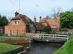 The River Pang in Bradfield village |
|
 Bradfield |
|
| Area | 16.67 km2 (6.44 sq mi) |
|---|---|
| Population | 2,177 (2011 census)[1] |
| – density | 131/km2 (340/sq mi) |
| OS grid reference | SU6073 |
| Civil parish | Bradfield |
| Unitary authority | West Berkshire |
| Ceremonial county | Berkshire |
| Region | South East |
| Country | England |
| Sovereign state | United Kingdom |
| Post town | READING |
| Postcode district | RG7 |
| Dialling code | 0118 |
| Police | Thames Valley |
| Fire | Royal Berkshire |
| Ambulance | South Central |
| EU Parliament | South East England |
| UK Parliament | Newbury |
Coordinates: 51°26′56″N 1°07′55″W / 51.449°N 1.132°W
Bradfield is a village and civil parish in Berkshire, England. Aside from farms and a smaller amount of woodland its main settlements are Bradfield Southend, its medieval-founded nucleus and the hamlet of Tutts Clump.
Bradfield village is the home of the public school Bradfield College, whilst Bradfield Southend is well-known locally for the display of outdoor Christmas lights put on by many residents.
Location
Bradfield's traditional centre is on the mid-flood plain of the River Pang centred 6 miles (9.7 km) west of Reading, where the Theale to Compton road crosses the river. Bradfield Southend is centred about a mile to the south west on the gentle escarpment between the Pang and the Kennet. Other villages and hamlets in the parish include Southend, Tutts Clumps and Rotten Row. There is a complex of ponds in the vicinity of the latter containing very good examples of artesian aquifers. Best known of these is 'The Blue Pool' which has delighted generations of children. In recent years, the current owners have had to deny access to the site due to minor fluctuating levels of pollution. Plans for better access have not yet come to fruition.
Landmarks
Bradfield's war memorial is the last work of George Blackall Simmonds, which commemorates the deaths in the First World War of those of the 2nd Battalion, South Wales Borderers, including his son.
Local area
Position: grid reference SU605726 (Bradfield), SU596706 (Bradfield Southend) (centres)
Nearest town/city: Reading
Nearby villages: Theale, Stanford Dingley, Englefield, Tidmarsh, Upper Basildon, Pangbourne
Demography
| Output area | Homes owned outright | Owned with a loan | Socially rented | Privately rented | Other |
|---|---|---|---|---|---|
| Civil parish | 218 | 203 | 48 | 116 | 36 |
Local government
Bradfield is a civil parish with an elected parish council – this makes up the second layer of local government. It falls within the area of the unitary authority of West Berkshire, the main layer of local government.
See also
References
External links
| Wikimedia Commons has media related to Bradfield, Berkshire. |