Barra do Quaraí
| Barra do Quaraí | |||
|---|---|---|---|
| town | |||
| |||
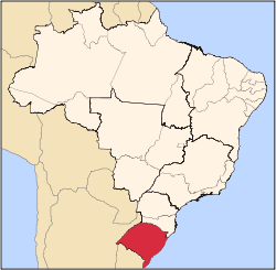
 Location of Barra do Quaraí | |||
| Coordinates: 30°12′25″S 57°33′18″W / 30.20694°S 57.55500°WCoordinates: 30°12′25″S 57°33′18″W / 30.20694°S 57.55500°W | |||
| Country |
| ||
| Region | South | ||
| State | Rio Grande do Sul | ||
| Founded | December 28, 1995 | ||
| Government | |||
| • Mayor | Iad Mahoud Abder Rahim Choli | ||
| Area | |||
| • Total | 1,056.14 km2 (407.78 sq mi) | ||
| Elevation | 35 m (115 ft) | ||
| Population (2015) | |||
| • Total | 4,201 | ||
| • Density | 4.0/km2 (10/sq mi) | ||
| [1] | |||
| Time zone | BRT (UTC-3) | ||
| • Summer (DST) | BRST (UTC-2) | ||
| HDI (2000) | 0.777 – medium[2] | ||


Barra do Quaraí (also Quarahim in archaic Portuguese spelling) is a Brazilian municipality located near the border with Uruguay (on the Rio Quaraí) and Argentina on the Uruguay River. The town became the westernmost city in the state of Rio Grande do Sul and in all Southern Brazil when it was separated from the municipality of Uruguaiana on December 28, 1995. The population is 4,201 (2015 est.) in an area of 1056.14 km².[1] Its elevation is 35 m. It is located 717 km west of the state capital of Porto Alegre, and roughly the same distance northwest of Montevideo, Uruguay.
See also
References
- 1 2 Instituto Brasileiro de Geografia e Estatística
- ↑ "Archived copy". Archived from the original on 2009-10-03. Retrieved 2009-12-17. - UNDP
External links
- http://www.citybrazil.com.br/rs/barradoquarai/ (Portuguese)
This article is issued from Wikipedia - version of the 11/20/2016. The text is available under the Creative Commons Attribution/Share Alike but additional terms may apply for the media files.