Herval
| Herval | |
|---|---|
| Municipality | |
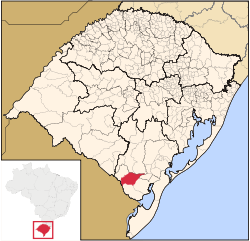 Location in Rio Grande do Sul state | |
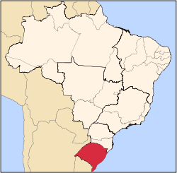
 Herval Location in Brazil | |
| Coordinates: 32°1′26″S 53°23′45″W / 32.02389°S 53.39583°WCoordinates: 32°1′26″S 53°23′45″W / 32.02389°S 53.39583°W | |
| Country |
|
| Region | South Region |
| State | Rio Grande do Sul |
| Mesoregion | Sudeste Rio-Grandense |
| Microregion | Jaguarão |
| Area | |
| • Total | 1,757.84 km2 (678.71 sq mi) |
| Population (2015) | |
| • Total | 6,975 |
| • Density | 4.0/km2 (10/sq mi) |
| Time zone | BRT/BRST (UTC-3/-2) |
| Website |
www |
Herval is a Brazilian municipality in the southern part of the state of Rio Grande do Sul. The population is 6,975 (2015 est.) in an area of 1757.84 km².[1] Its elevation is 287 m. Its main industry is agriculture.
Herval is situated south of the Piratini River, which was defined in 1777 as the border between the Spanish and Portuguese possessions. The current border between Uruguay and Brazil lies further south, at the Jaguarão River.
Herval is famous for its international rodeo festival, organized every January.
Bounding municipalities
References
External links
- http://www.citybrazil.com.br/rs/herval/ (Portuguese)
This article is issued from Wikipedia - version of the 8/28/2016. The text is available under the Creative Commons Attribution/Share Alike but additional terms may apply for the media files.