Cachoeira do Sul
| Cachoeira do Sul | ||
|---|---|---|
| Municipality | ||
|
Catedral Nossa Senhora da Conceição | ||
| ||
| Nickname(s): Capital Nacional do Arroz "National Rice Capital" | ||
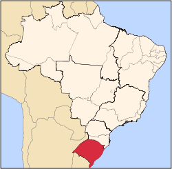
 Location within Rio Grande do Sul | ||
| Coordinates: 30°02′21″S 52°53′38″W / 30.03917°S 52.89389°WCoordinates: 30°02′21″S 52°53′38″W / 30.03917°S 52.89389°W | ||
| Country | Brazil | |
| Region | South | |
| State | Rio Grande do Sul | |
| Founded | 1820 | |
| Government | ||
| • Mayor | Neiron Viegas (PT) | |
| Area | ||
| • Total | 3,715 km2 (1,434 sq mi) | |
| Elevation | 68 m (223 ft) | |
| Population (2006 est.) | ||
| • Total | 89,669 | |
| • Density | 24/km2 (63/sq mi) | |
| Time zone | UTC-3 (UTC-3) | |
| • Summer (DST) | UTC-2 (UTC-2) | |
| Website | cachoeiradosul.rs.gov.br | |


Cachoeira do Sul is a municipality of the state of Rio Grande do Sul, Brazil.
It is located at a latitude of 30º02'21" S and a longitude of 52º53'38" W, at an approximate height of 68 meters over sea level. Its population in 2004 was approximately 89120 and its surface area is 3715.5 square kilometers.
This article is issued from Wikipedia - version of the 5/15/2016. The text is available under the Creative Commons Attribution/Share Alike but additional terms may apply for the media files.