Lar (Jammu and Kashmir)
This article is about a town in Ganderbal district of Jammu and Kashmir. For other uses, see Lar (disambiguation).
| Lar Chanthan Gulab Pora | |
|---|---|
| Town | |
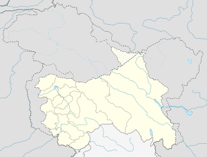 Lar  Lar Location in Jammu and Kashmir, India | |
| Coordinates: 34°15′43″N 74°45′18″E / 34.262°N 74.755°ECoordinates: 34°15′43″N 74°45′18″E / 34.262°N 74.755°E | |
| Country |
|
| State | Jammu and Kashmir |
| District | Ganderbal |
| Elevation | 1,650 m (5,410 ft) |
| Population (2011) | |
| • Total | 50,491 |
| Languages | |
| • Official | Urdu |
| Time zone | IST (UTC+5:30) |
| PIN | 191201 |
| Telephone code | 1942419 |
| Vehicle registration | JK16 |
| Sex ratio | 951 ♂/♀ |
Lar (Urdu: لار) is a town and a notified area committee in Ganderbal district, of Jammu and Kashmir, India. It is a newly established tehsil carved out of Ganderbal Tehsil. It is situated on newly constructed bypass (NH 1D) at the foothills of himalayan mountains in the catchment area of Nallah Sindh.
Geography
Lar is located 34°15′43″N 74°45′18″E / 34.262°N 74.755°E.[1] 6 km north of Ganderbal town at an average elevation of 1,650 metres (5,410 ft).
Demographics
As of 2011 India census,[2] Lar had a population of 50491, Males constitute 52% of the population and females 48%. Lar has an average literacy rate of 59.99% higher than the national average of 59.5%.[3]
See also
References
- ↑ Wikimapia- Lar
- ↑ "Census of India 2001: Data from the 2001 Census, including cities, villages and towns (Provisional)". Census Commission of India. Archived from the original on 2004-06-16. Retrieved 2008-11-01.
- ↑ "Lar Tehsil" (pdf). NRHM. Retrieved 2012-06-12.
This article is issued from Wikipedia - version of the 12/2/2016. The text is available under the Creative Commons Attribution/Share Alike but additional terms may apply for the media files.