Chenani
| Chenan | |
|---|---|
| city | |
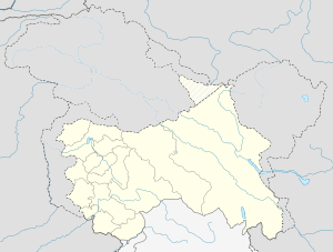 Chenan  Chenan Location in Jammu and Kashmir, India | |
| Coordinates: 33°02′N 75°17′E / 33.03°N 75.28°ECoordinates: 33°02′N 75°17′E / 33.03°N 75.28°E | |
| Country |
|
| State | Jammu and Kashmir |
| District | Udhampur |
| Elevation | 1,062 m (3,484 ft) |
| Population (2001) | |
| • Total | 2,159 |
| Languages | |
| • Official | Urdu, Dogri, Kashmiri language |
| Time zone | IST (UTC+5:30) |
| PIN | 182141 |
| Telephone code | 01992 |
| Vehicle registration | JK 14 |
Chenani is a town and tehsil in the Udhampur district, in the Indian state of Jammu and Kashmir. It is governed by a Notified Area Council (city council). Prior to 1947, it was an internal jagir ruled by a tributary ruler in the princely state of Jammu and Kashmir.
India's longest road tunnel, the 9.2 km long Chenani-Nashri Tunnel or Patnitop Tunnel is being constructed about 2 km from Chenani town to reduce the distance from Jammu to Srinagar and reduce traffic jams on NH-1A that occur due to snowfall and avalanche in winter at Patnitop.[1]
History
Until 1947, Chenani principality was ruled by Chandel (Antahal) Rajputs who came to this place in the 9th century AD from Kot Kalhur, Bilaspur Himachal Pradesh. The narrative goes like this that natives of this region approached Raja Bir Chand of Bilaspur and requested him to save them from the atrocities of local Ranas. Raja Bir Chand sent his younger brother Raja Gambhir Chand along with army to help the natives. On reaching Chenani, Raja Gambhir Chand made Ranas to leave the place and established an independent State which continued till 1947. During this period 52 Rajas of this clan of Rajputs ruled this erstwhile princely state.
Geography
Chenani is located at 33°02′N 75°17′E / 33.03°N 75.28°E[2] at a distance of 90 km north-east of Jammu city. It has an average elevation of 1,062 metres (3,487 feet). River Tawi flows through Chenani town. It is connected well by road. NH 1A which connects Kashmir to rest of country passes through Chenani. Buses from Jammu take about 3 to 4 hours to reach Chenani. Mini buses are also available for Chenani from Udhampur. The nearest railway station from Chenani is Udhampur, 25 km away.
Chenani is the gateway to famous Sudhmahadev, Gourikund and Mantalai shrines that can be reached by bus or taxi from Chenani.
Demographics
As of 2001 India census,[3] Chenani had a population of 2159, with males constituting 55% of the population. Chenani has an average literacy rate of 80%, higher than the Indian national average of 59.5%; with male literacy of 85% and female literacy of 73%. 12% of the population is under 6 years of age.
The religious composition of the Chenani tehsil is: Hindu 75.92%, Muslim 21.68%, Christian 0.27%, Sikh 2.06%, Buddhist 0.08%[4]
Chenani-Nashri Tunnel
A 9.2 km long tunnel (Chenani-Nashri Tunnel) is being constructed about 2 km from Chenani town. The tunnel will be the India's longest road tunnel when completed. It will reduce the distance from Chenani to Nashri by 31 km and reduce traffic jams on NH-1A that occur due to snowfall and avalanche in winter at Patnitop. About 2 km of the tunnel had been excavated by April 2012,[5] about 50% of the length had been excavated by January 2013.[6] and the excavation was completed in July 2015. As of October 2016, the tunnel is expected to be inaugurated in November 2016.[7]
In addition to the main road tunnel (13.3m in diameter), there will be a smaller parallel escape tunnel (5m in diameter) for emergency services and extraction of smoke and persons in case of fire and accident. The tunnel is located at an elevation of 1200m and is being built using the latest NATM technique of sequential excavation and support.[8] The tunnel will have a maximum overburden of 1,050m. The tunnel will reduce the elevation and hairpin bends associated with the existing highway. The gradient will also be reduced from 4.5% to about 0.5%.[9]
The Southern portal (end) of the tunnel is at 33°02′47″N 75°16′45″E / 33.0463°N 75.2793°E and the Northern portal (end) of the tunnel is at coordinates 33°07′43″N 75°17′34″E / 33.1285°N 75.2928°E. When the tunnel is completed, the highway will no longer pass through Patnitop. The tunnel will reduce the length of the highway by 31 km and the highway will bypass Patnitop.
A new emergency hospital with capacity of 100 beds is also being completed at Chenani.
References
- ↑ http://www.constructionweekonline.in/article-7845-chenani_nashri_tunnel_completes_2_kms_excavation
- ↑ Falling Rain Genomics, Inc - Chenani
- ↑ "Census of India 2001: Data from the 2001 Census, including cities, villages and towns (Provisional)". Census Commission of India. Archived from the original on 2004-06-16. Retrieved 2008-11-01.
- ↑ http://www.census2011.co.in
- ↑ http://www.constructionweekonline.in/article-7845-chenani_nashri_tunnel_completes_2_kms_excavation
- ↑ "Archived copy". Archived from the original on 2013-02-08. Retrieved 2013-02-05.
- ↑ http://www.greaterkashmir.com/news/jammu/9-km-chenani-nashri-tunnel-to-be-thrown-open-in-november/230732.html
- ↑ "Leighton India :: Chenani-Nashri Tunnel". www.leighton.co.in. Retrieved 2016-03-13.
- ↑ "Chenani-Nashri Tunnel (Patnitop Tunnel), India". Road Traffic Technology. Retrieved 2016-03-13.