Sunderbani
| Sunderbani Sunderbani | |
|---|---|
| city | |
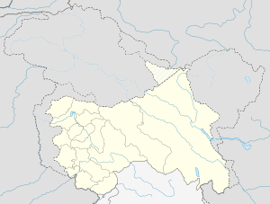 Sunderbani  Sunderbani Location in Jammu and Kashmir, India | |
| Coordinates: 33°02′N 74°29′E / 33.04°N 74.49°ECoordinates: 33°02′N 74°29′E / 33.04°N 74.49°E | |
| Country |
|
| State | Jammu and Kashmir |
| District | Rajouri |
| Named for | after the queen Sundra |
| Government | |
| • Type | democratic |
| • Body | M.C. Sunderbani |
| Elevation | 633 m (2,077 ft) |
| Population (2011) | |
| • Total | 10,531 |
| Languages | |
| • Official | Dogri |
| Time zone | IST (UTC+5:30) |
Sunderbani or Sundal Bani is a town and a notified area committee in Rajouri district in the Indian state of Jammu and Kashmir.
Geography
Sunderbani is located at 33°02′N 74°29′E / 33.04°N 74.49°E.[1] It has an average elevation of 633 metres (2,077 feet).
Demographics
As of 2011 India census,[2] Sunderbani had a population of 10,531. Males constitute 67% of the population and females 33%. Sunderbani has an average literacy rate of 84%, higher than the national average of 58.5%: male literacy is 88%, and female literacy is 77%. In Sunderbani, 25% of the population is under 6 years of age. Village Mallah is about 12 km from Sunderbani. There are high location, is known as Mallah Top.There is also an ashram of shri shri 1008 swami vishwatmanand ji maharaj known as 'SHIVKASHI' which also includes SVS Educational Complex which caters to the educational needs of the district.
References
- ↑ Falling Rain Genomics, Inc - Sunderbani
- ↑ "Census of India 2001: Data from the 2001 Census, including cities, villages and towns (Provisional)". Census Commission of India. Archived from the original on 2004-06-16. Retrieved 2008-11-01.