Ganderbal district
| Ganderbal district Ganderbal گاندربل | |
|---|---|
| District | |
 Location in Jammu and Kashmir, India | |
| Coordinates: 34°08′N 74°28′E / 34.14°N 74.47°ECoordinates: 34°08′N 74°28′E / 34.14°N 74.47°E | |
| Country |
|
| State | Jammu and Kashmir |
| Headquarters | Ganderbal |
| Elevation | 1,616 m (5,302 ft) |
| Population (2011) | |
| • Total | 297,003 |
| Languages | |
| • Official | Kashmiri |
| Time zone | IST (UTC+5:30) |
| Telephone code | 01942 |
| Vehicle registration | JK16 |
| Sex ratio | 869 ♂/♀ |
| Literacy | 59.99% |
| Website |
ganderbal |
Ganderbal District (گاندربل ضلع (Perso-Arabic)) is a newly formed district of the state of Jammu and Kashmir of India. It has 5 tehsils Tullamulla, Lar, Wakoora, Ganderbal and Kangan.
Historic sites and remains
Ganderbal, like the rest of the Kashmir Valley, has witnessed many vicissitudes and experienced many upheavals from time to time. No significant ancient building or archaeological site is found in the district today, except for the Naranag temple, as most of the ancient architectural monuments in the area were destroyed during the rule of Sultan Sikander. What must have once been magnificent architectural show pieces are now in grand ruins.
Kheer Bhawani
Naranag Temple
The Naranag Temple[1] is one of the important archaeological sites of the country. Naranag, a group of temples, is situated in the lap of Harmukh Mountain about 50 kilometres (31 mi) from Srinagar city. The site consists of a cluster of temples facing each other at a distance of about 100 metres (330 ft). Historians say that the temple is dedicated to Lord Shiva by the 8th-century ruler Lalithdatiya Muktadiya. It is believed that the King Awantivarman paid a visit and donated a pedestal for bathing at Bhutsher. Even today one gets surprised over art and skill of the builders of this temple. Its impressive architecture reveals the glorious past, the magnificent art of the 8th century. The government has only recently constructed walls to protect it from encroachments and nothing else has been done. It is now left in ruins of which only faint traces have survived. This temple has the typical Aryan structure as was present in Aryan Kashmir.
Geography
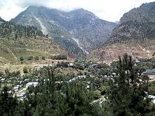
Ganderbal district, with its district headquarters located at 33°44′N 75°09′E / 33.73°N 75.15°E,[2] at an average elevation of 1,950 metres (6,400 ft) above sea level, at a distance of 21 kilometres (13 mi) from Srinagar city.
Ganderbal district is spread across the Sind River. The river is considered as the lifeline of the district. It is the only river in Jammu and Kashmir state on which three hydroelectric power stations are functional; besides that the river provides water for irrigation, 80% population[3] of the district is engaged with farming. The sand (bajri) of this river has a great value for money for its quality.
The district is constituted into Seven tehsils:
- Ganderbal
- Kangan
- Lar
- Wakura
- Tullamulla
- Gund
It is further divided into nine blocks: Ganderbal, Wakoora, Lar, Kangan, Gund, Shearpathri, Phaag, Manigam and Batwina.[4] Each block consists of a number of panchayats. Ganderbal District has 2 assembly constituencies: Kangan and Ganderbal.[5]
Climate
Ganderbal district possesses all the typical characteristics of the climate of Kashmir Valley as a whole. In the heat of July, the breeze of the Singh River is a welcome relief. Sir Walter Lawrence writes in his book The Valley of Kashmir that in latitude, Kashmir corresponds with Peshawar, Baghdad and Damascus in Asia: with Fez in Morocco: and South Carolina in America, but it presents none of the characteristics of those countries. People have linked the climate of Kashmir to that of Switzerland until the end of May, and of Southern France in July and August. But it is impossible to speak of Kashmir as possessing any one climate or group of characteristics. Every hundred feet of elevation brings some new phase of climate and of vegetation.
Tourism
The Ganderbal district is located in valley of the Sindh River, also known as Nallah Sindh. It is rich in landscape and is often called the District of Lakes, as it possesses the highest number of lakes in the state of Jammu and Kashmir.
Sonamarg
This famous hill station is situated 80 kilometres (50 mi) from Srinagar and located on the banks of Sindh River at an altitude of 2,800 meters. Sonamarg also hosts the International Championships of Rafting on Sindh River. It presents a glamorous look due to its alpine meadows, snow-clad mountains, and healthy climate. Sonamarg skirts Sindh River and torrential flow of water in this river enriches its awesome beauty. Besides several hotels in private sector have come up here and these hotels provide modern facilities to their guests. A number of treks in this region also begin from Sonamarg to high altitude lakes of Vishansar, Krishansar, Gadsar and Gangabal stocked with snow trout and brown trout.
Manasbal Lake
Manasbal Lake is the main attraction for tourists in Ganderbal district, 12 kilometres (7.5 mi) north west of district headquarters of Ganderbal. It is 5 kilometres (3.1 mi) long and 1 kilometre (0.62 mi) wide. It is located in the Jhelum valley, north of Srinagar city in the State of Jammu and Kashmir in India. The name Manasbal is said to be a derivative of the Lake Manasarovar.[6] Lake is encircled by three villages: Jarokbal, Kondabal (also called Kiln place; is situated on the north-eastern side of the lake) and Ganderbal and is stated to be the deepest lake (at 13 m or 43 ft depth) in the Kashmir valley. The large growth of lotus (Nelumbo nucifera) at the periphery of the lake (blooms during July and August) adds to the beauty of the clear waters of the lake. The Mughal garden, called the Garoka, (meaning bay window) built by Nur Jahan overlooks the lake.[7]
The lake is a good place for birdwatching as it is one of the largest natural stamping grounds of aquatic birds in Kashmir and has the sobriquet of "supreme gem of all Kashmir Lakes".[8][9] The rootstocks of lotus plant which grows extensively in the lake are harvested and marketed, and also eaten by the local people.[6]
The lake is approached from Srinagar by a 30-kilometre (19 mi) road via Shadipur, Nasim and Gandarbal. Road to Wular Lake, the largest lake in Kashmir, passes through this lake, via Safapur.[6]
Prang

Prang village is 12 kilometres far from the central hub (beehama) of district Ganderbal, towards the east. Srinagar-Leh National Highway (NH 1D) passes right through the middle of this village. This village falls under the jurisdiction of tehsil Kangan.
OVERVIEW!
Prang village is meant for its natural and enthralling beauty.The main attraction of this village is its garden, which attracts the tourists throughout the year. This village is also famous for its clear streams, cold air and mighty mountains.
The Prang garden used to be the picnic spot in 1990's before army came and established the base camp there. However, the army camp was later evacuated from the garden in the year 2008. This garden is situated on the banks of the famous Sindh River , and forested slopes are on the other side of the garden adding more charm to its beauty. The famous Environmental park (usually known as the "dumping park") is in the adjacent village of Prang.
This village is considered as the main hub for its adjacent areas.The adjacent areas of this village are "Lari Prang, Check Prang, Herra Prang, Pati Prang and dragtung".
Harmukh

Harmukh (also known as Mount Haramukh or Harmukh mountain) is a mountain with a peak elevation[10] of 16,890 ft (5,148 metres), in Ganderbal district of Indian State of Jammu & Kashmir. Harmukh is part of the Himalaya Range, and is located between Sindh River to its south and Neelum River to its north. It rises from Gangabal Lake[11] in the vicinity of Kashmir valley. It is more hazardous to reach Mount Haramukh from the east and south side of Ganderbal and has never been climbed from these sides; thus, it is mostly climbed in the north-west from the Arin Bandipore side.
Harmukh was first climbed by the Great Trigonometric Survey's Thomas Montgomerie in 1856 and made the first survey of the Karakoram some 210 km (130 miles) to the south, and sketched the two most prominent peaks, labelling them K1 and K2.[12] Harmukh was later climbed by many other climbers.[13] Therefore, Harmukh is the mountain from which the world‘s 2nd highiest mountain peak K2 was discovered and the Serveyer‘s mark K2 continues to be the name.
Gangabal Lake
Gangabal Lake (Urdu:-ﮔﻨﮕﺒﻞ ﺟﮭﻴﻞ), also called Gangbal Lake, is a lake situated at the foothills of Mount Haramukh (the highest mountain peak in the vicinity of Kashmir valley)[14] in Ganderbal district, north of Srinagar city in the state of Jammu and Kashmir in India. It is an alpine high altitude oligotrophic lake,[15] and is home to many types of fishes[16] of which one is the brown trout.[17]
The lake has a maximum length of 2.5 kilometres (1.6 mi) and maximum width of 1 kilometre (0.62 mi). It is fed by precipitation, glaciers and springs. The lake water outflows to a nearby small lake (Nundakol)[18] and then via Wangath nallah[19] to Sindh River[20] The trout fishes are present in the lake.[21] Gangabal lake is approached from Srinagar 45 kilometres (28 mi) by road via Ganderbal up to Naranag[22] and then a 15 kilometres (9.3 mi) track upslope.
Education
- Naqshbandia School of Education , Upper Rangil Ganderbal
- 4 Seasons play cum Preparatory School, Arampora Ganderbal(Under Construction)
- Central University of Kashmir Ganderbal (under construction)
- New Dream Land School, Beehama Ganderbal
- RP School GulaBagh Ganderbal
- Vijay Memorial School
- Hill Top School
- Government polytechnique College Armpora Ganderbal
- Government Physical college Ganderbal
- Computer Oriented Educational Institute Ganderbal
- Baby's Land Public High School Wakura
- Sheikhul Alam Public School Nawabbagh lar Ganderbal
- Nida ul Quran Institute of Islamic Studies and Research Gadoora Ganderbal
- SKUAST, Faculty of Fishries, Rangil
- SKUAST, Faculty of Forestry, Benhama (under construction)
- Government Degree College, Ganderbal
- Sheikh-ul-Alam Public school Gadoora Ganderbal
- Government Degree College, Kangan
- Hyderiya Model School, Tulla Mulla, Ganderbal
- Sainik School, Manasbal
- Kirmania Model High School Batwina Ganderbal
- Alamdar-e-Kashmir Educational institute
- Public High School Watlar
- Sultania Higher Secondary School Ganderbal.
- New Tiny Hearts School, Duderhama.
- Oxford High School, Duderhama.
- Government Middle School, Duderhama
- Government Physical College, Gadoora Ganderbal
- Abrar public school prang kangan.
- Zia Educational Institute Batwina Ganderbal.
- Gousia Islamic Educational Institution Batwina.
- Government Boys Higher Secondary School Batwina Ganderbal.
- Shaheen Public School Manigam
- The H.K.M.C (RA) Educational Institute Manigam
- Modern Kids Care Institute Of Education Lar
- Iqra Model secondary school, Nagbal
- Green Way Public School ,Khalamulla Alusteng.
- Govt. High School Khalamulla Alusteng
- Govt .Middle School Khalamulla Alusteng.
- Syed Maqsood Model School Kurhama
Gallery
-

Apples of Nawabagh, Ganderbal
-

Apples exported from Ganderbal district
-
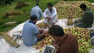
Apples of Nawabagh, Ganderbal
-

Apples of Nawabagh, Ganderbal
delhi public school sehpora ganderbal
See also
References
- ↑ "Naranag temple in ruins". kashmirmonitor.org. Retrieved 2012-04-25.
- ↑ "Falling Rain Genomics, Inc - Ganderbal". fallingrain.com. Retrieved 2012-04-24.
- ↑ "Agriculture directory of Ganderbal". diragrikmr.nic. Retrieved 2012-04-25.
- ↑ Statement showing the number of blocks in respect of 22 Districts of Jammu and Kashmir State including newly Created Districts dated 2008-03-13, accessed 2012-04-24
- ↑ "ERO's and AERO's". Chief Electoral Officer, Jammu and Kashmir. Retrieved 2012-04-24.
- 1 2 3 http://kashmir-tourism.com/jammu-kashmir-lakes-mansabal-lake.htm, Manasbal Lake
- ↑ http://www.indiainfoweb.com/jammu-kashmir/lakes/mansabal-lake.html Mansbal lake
- ↑ http://www.ilec.or.jp/database/asi/asi-57.html Manasbal Lake
- ↑ kashmir lakes
- ↑ "How high is Harmukh". wolframalpha.com. Retrieved 2012-04-24.
- ↑ "Geography of Kashmir". kousa.org. Retrieved 2012-04-24.
- ↑ Curran, Jim (1995). K2: The Story of the Savage Mountain. Hodder & Stoughton. p. 25. ISBN 978-0340660072.
- ↑ "Rimo expeditions". rimoriverexpeditions.com. Retrieved 2012-04-25.
- ↑ "Trekking Kashmir". gaffarakashmir.com. Retrieved 2012-04-19.
- ↑ Raina, HS; KK Vass (May–June 2006). "Some biological features of a freshwater fairy shrimp, Branchinecta schantzi, Mackin, 1952 in the Northwestern Himalayas, India" (PDF). J. Indian Inst. Sci. 86: 287–291. Retrieved 21 February 2012.
- ↑ "Fishes and Fisheries in high altitude lakes, Vishansar, Gadsar, Gangabal, Krishansar". Fao.org. Retrieved 2012-04-19.
- ↑ Petr, ed. by T. (1999). Fish and fisheries at higher altitudes : Asia. Rome: FAO. p. 72. ISBN 92-5-104309-4.
- ↑ "Kashmir First". Kashmir First. 1943-08-25. Retrieved 2015-12-24.
- ↑ "Water Resources Development Projects in Indus Basin". Nih.ernet.in. 2004-08-11. Retrieved 2015-12-24.
- ↑ A major tributary to the Jehlum river.
- ↑
- ↑ "Jammu and Kashmir update". jammuandkashmirupdate.com. Retrieved 2012-04-25.
External links
 |
Bandipore district | | ||
| |
Kargil district | |||
| ||||
| | ||||
| Baramula district | Srinagar district | Anantnag district |