Srinagar Jammu National Highway
| Srinagar Jammu National Highway | |
|---|---|
| Route information | |
| Maintained by National Highways Authority of India | |
| Length: | 295 km (183 mi) |
| Major junctions | |
| From: | Lal Chowk, Srinagar district |
| To: | Jammu, Jammu district |
| Location | |
| Major cities: | Srinagar, Pulwama, Anantnag, Ramban, Udhampur, Jammu |
| Highway system | |
Srinagar Jammu National Highway is the part of National Highway 44 (India) system and connects Srinagar (kashmir valley) with Jammu City.[1] The distance between Jammu Tawi and Srinagar is 295 km.[2] It is one of the two road links (other being Mughal road) that connects Kashmir Valley with rest of India. The traffic on the highway is controlled by two control rooms, one in Srinagar and other in Jammu.
Features
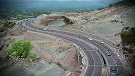
The highway starts from Lal Chowk, Srinagar and then passes through Pulwama district, Anantnag district, Kulgam district, Ramban district, Udhampur district and ends in Jammu city. The highway lies in Kashmir valley for first 68 km up to Qazigund and then passes through series of Mountains up to Jammu. The highway is famous for Patnitop Hill station, Jawahar Tunnel, Sweets of Kud and Tea of Sarmuli. The highway is often closed during winter days due to heavy snowfall in Kashmir valley and district Ramban. Many landslides and avalanches in the mountainous region leads to closure of highway during winters.[3] The railway line connecting kashmir valley with Banihal has eased traffic on the highway as many people prefer to travel in train up to Banihal as it is economical and time saving. The government of Jammu and Kashmir spents lot of money every year on maintenance of the highway. At many sites new roads with less number of road curves and tunnel are constructed which would not only provide comfort to the passengers but would also reduce distance between two cities. Udhampur-Jammu highway is the small part of this highway.[4]
Traffic control rooms
Traffic on the highway is controlled by Traffic control rooms of two capitals.
- The contact number of Traffic control room Srinagar is 01942450022 and
- The contact number of Traffic control room Jammu is 01942459048.
These numbers help the people to get latest updates on the conditions of the highway and help them to postpone their journey in case of bad weather.[5]
See also
References
- ↑ see National Highway 1A (India) on http://www.wikipedia.com
- ↑ "distancebetween.com: The Leading Distance Between Site on the Net". distancebetween.com. Retrieved 2014-08-07.
- ↑ "greaterkasmir.com". greaterkasmir.com. Retrieved 2014-08-07.
- ↑ "greaterkashmir.com". Retrieved 4 February 2015.
- ↑ traffic control room Srinagar sign board