Vale, Avery County, North Carolina
This article is about the community in Avery County, North Carolina. For other uses, see Vale (disambiguation).
| Vale | |
|---|---|
| Unincorporated community | |
 Vale Location within the state of North Carolina | |
| Coordinates: 36°05′49″N 81°56′42″W / 36.09694°N 81.94500°WCoordinates: 36°05′49″N 81°56′42″W / 36.09694°N 81.94500°W | |
| Country | United States |
| State | North Carolina |
| County | Avery County |
| Elevation | 3,550 ft (1,082 m) |
| Time zone | Eastern (EST) (UTC-5) |
| • Summer (DST) | EDT (UTC-4) |
| ZIP code | 28657 |
| Area code(s) | 828 |
| GNIS feature ID | 1023058[1] |
Vale is an Unincorporated community in Avery County, North Carolina, United States. It is located northwest of Newland on Old Toe River Road.
History
From 1904 to 1940, Vale was a flag stop along the East Tennessee and Western North Carolina Railroad; between Minneapolis and Newland. Old Toe River Road now resides on what was the old railway path.
See also
References
Municipalities and communities of Avery County, North Carolina, United States | ||
|---|---|---|
| Towns | 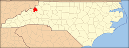 | |
| Villages | ||
| Unincorporated communities | ||
| Footnotes | ‡This populated place also has portions in an adjacent county or counties | |
This article is issued from Wikipedia - version of the 3/23/2014. The text is available under the Creative Commons Attribution/Share Alike but additional terms may apply for the media files.