Montezuma, North Carolina
| Montezuma | |
|---|---|
| Unincorporated community | |
 Montezuma Location within the state of North Carolina | |
| Coordinates: 35°58′17″N 82°00′42″W / 35.97139°N 82.01167°WCoordinates: 35°58′17″N 82°00′42″W / 35.97139°N 82.01167°W | |
| Country | United States |
| State | North Carolina |
| County | Avery County |
| Founded | 1883 |
| Elevation | 2,766 ft (843 m) |
| Time zone | Eastern (EST) (UTC-5) |
| • Summer (DST) | EDT (UTC-4) |
| ZIP code | 28653 |
| Area code(s) | 828 |
| GNIS feature ID | 1013656[1] |
Montezuma is an unincorporated community in Avery County, North Carolina, United States. Before its founding in 1883, it had two variant names, Aaron and Bull Scrape. The community is located on Old State Highway 181 and is on the Eastern Continental Divide.
History
Between 1904 and 1940, Montezuma was a stop along the East Tennessee and Western North Carolina Railroad between Newland and Linville, with a spur to Pineola .
References
Municipalities and communities of Avery County, North Carolina, United States | ||
|---|---|---|
| Towns | 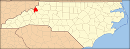 | |
| Villages | ||
| Unincorporated communities | ||
| Footnotes | ‡This populated place also has portions in an adjacent county or counties | |
This article is issued from Wikipedia - version of the 8/19/2016. The text is available under the Creative Commons Attribution/Share Alike but additional terms may apply for the media files.