South Kilkerran, South Australia
| South Kilkerran South Australia | |||||||||||||
|---|---|---|---|---|---|---|---|---|---|---|---|---|---|
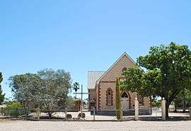 St John's Lutheran church at South Kilkerran | |||||||||||||
 South Kilkerran | |||||||||||||
| Coordinates | 34°26′17″S 137°35′24″E / 34.438°S 137.590°ECoordinates: 34°26′17″S 137°35′24″E / 34.438°S 137.590°E | ||||||||||||
| Postcode(s) | 5573 | ||||||||||||
| Location | 9 km (6 mi) SW of Maitland | ||||||||||||
| LGA(s) | Yorke Peninsula Council | ||||||||||||
| State electorate(s) | Goyder | ||||||||||||
| Federal Division(s) | Grey | ||||||||||||
| |||||||||||||
| Footnotes | Adjoining localities[1] | ||||||||||||
South Kilkerran is a settlement on Yorke Peninsula in the Australian state of South Australia, between Maitland and Port Victoria.[2][3]
South Kilkerran is still the home of St John's Lutheran church.[4] It formerly also had a St Paul's Lutheran church,[5] and both churches had schools associated with them,[6] which are now closed.
South Kilkerran is located within the federal division of Grey, the state electoral district of Goyder and the local government area of the Yorke Peninsula Council.[7][8]
References
- ↑ "New Ward Structure 2014". Yorke Peninsula Council. Retrieved 21 October 2015.
- ↑ "2905.0 - Statistical Geography: Volume 2 -- Census Geographic Areas, Australia, 2006". Australian Bureau of Statistics. Retrieved 8 December 2009.
- ↑ "Placename Details: South Kilkerran". Land Services, government of South Australia. 17 October 2013. SA0062651. Retrieved 18 September 2015.
- ↑ "St John's South Kilkerran". Maitland Lutheran Parish, South Australia. Retrieved 18 September 2015.
- ↑ "THE COUNTRY.". The Advertiser (Adelaide, SA : 1889 - 1931). Adelaide, SA: National Library of Australia. 20 February 1917. p. 10. Retrieved 18 September 2015.
- ↑ "SOUTH KILKERRAN.". The Observer (Adelaide). Adelaide, SA: National Library of Australia. 14 August 1915. p. 52. Retrieved 18 September 2015.
- ↑ "Goyder electorate boundaries as of 2014". ELECTORAL COMMISSION SA. Retrieved 23 July 2015.
- ↑ "Federal electoral division of Grey" (PDF). Australian Electoral Commission. Retrieved 24 July 2015.
This article is issued from Wikipedia - version of the 6/25/2016. The text is available under the Creative Commons Attribution/Share Alike but additional terms may apply for the media files.