Patoka Township, Dubois County, Indiana
| Patoka Township Dubois County | |
|---|---|
| Township | |
|
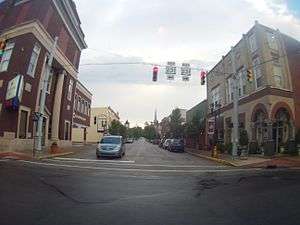
Downtown Huntingburg, in Patoka Township | |
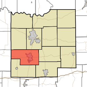 Location of Patoka Township in Dubois County | |
| Coordinates: 38°18′08″N 86°58′51″W / 38.30222°N 86.98083°WCoordinates: 38°18′08″N 86°58′51″W / 38.30222°N 86.98083°W | |
| Country | United States |
| State | Indiana |
| County | Dubois |
| Government | |
| • Type | Indiana township |
| Area | |
| • Total | 39.83 sq mi (103.2 km2) |
| • Land | 39.26 sq mi (101.7 km2) |
| • Water | 0.57 sq mi (1.5 km2) |
| Elevation[1] | 466 ft (142 m) |
| Population (2010) | |
| • Total | 7,527 |
| • Density | 191.7/sq mi (74.0/km2) |
| FIPS code | 18-58302[2] |
| GNIS feature ID | 453708 |
Patoka Township is one of twelve townships in Dubois County, Indiana. As of the 2010 census its population was 7,527 and it contained 3,056 housing units.[3]
Geography
According to the 2010 census the township has a total area of 39.83 square miles (103.2 km2), of which 39.26 square miles (101.7 km2) (or 98.57%) is land and 0.57 square miles (1.5 km2) (or 1.43%) is water.[3] Knebel Lake is in this township.
Cities and towns
Unincorporated towns
Adjacent townships
- Bainbridge Township (northeast)
- Jackson Township (east)
- Ferdinand Township (southeast)
- Cass Township (south)
- Lockhart Township, Pike County (west)
- Madison Township (northwest)
- Marion Township, Pike County (northwest)
Major highways
Cemeteries
The township contains three cemeteries: Central, Fairmount and Mayo.
References
- ↑ "US Board on Geographic Names". United States Geological Survey. 2007-10-25. Retrieved 2008-01-31.
- ↑ "American FactFinder". United States Census Bureau. Archived from the original on September 11, 2013. Retrieved 2008-01-31.
- 1 2 "Population, Housing Units, Area, and Density: 2010 - County -- County Subdivision and Place -- 2010 Census Summary File 1". United States Census. Retrieved 2013-05-10.
External links
Municipalities and communities of Dubois County, Indiana, United States | ||
|---|---|---|
| Cities | ||
| Towns | ||
| Townships | ||
| CDP | ||
| Other unincorporated communities | ||
| Ghost town | ||
| Footnotes | ‡This populated place also has portions in an adjacent county or counties | |
This article is issued from Wikipedia - version of the 9/10/2016. The text is available under the Creative Commons Attribution/Share Alike but additional terms may apply for the media files.