Marianna, Florida
| Marianna, Florida | |
|---|---|
| City | |
|
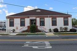
Marianna City Hall | |
| Motto: "City Of Southern Charm " | |
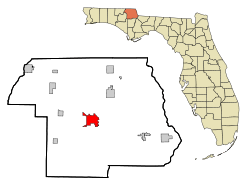 Location in Jackson County and the state of Florida | |
| Coordinates: 30°46′35″N 85°14′17″W / 30.77639°N 85.23806°WCoordinates: 30°46′35″N 85°14′17″W / 30.77639°N 85.23806°W | |
| Country |
|
| State |
|
| County | Jackson |
| Area | |
| • Total | 8 sq mi (20.9 km2) |
| • Land | 8 sq mi (20.8 km2) |
| • Water | 0 sq mi (0.1 km2) |
| Elevation | 167 ft (51 m) |
| Population (2012) | |
| • Total | 9,094 |
| • Density | 778.8/sq mi (298.1/km2) |
| Time zone | Central (CST) (UTC-6) |
| • Summer (DST) | CDT (UTC-5) |
| ZIP codes | 32446-32448 |
| Area code(s) | 850 |
| FIPS code | 12-43175[1] |
| GNIS feature ID | 0286422[2] |
| Website | www.cityofmarianna.com |
Marianna is a city in Jackson County, Florida, United States. The population was 6,230 at the 2000 census. It is the county seat of Jackson County[3] and is home to Chipola College. The official nickname of Marianna is "The City of Southern Charm."
History
Marianna was founded in 1828 by Scottish entrepreneur Scott Beverege and named the town after his wife, Mary and her friend Anna combining their names to form Marianna, it was named the county seat the following year, supplanting the earlier settlement of Webbville, which soon dissolved and no longer exists. Marianna was platted along the Chipola River and many plantation owners from North Carolina relocated to Jackson County for the fertile soil.
It is the final resting place of the Confederate governor of Florida, Governor John Milton, and the scene of a Civil War battle between a small home guard of about 150 boys, older men, and wounded soldiers, and a contingent of approximately 700 Federal troops.
Governor Milton owned Sylvania Plantation and hundreds of slaves, was the governor of Florida during the Civil War years. Governor Milton was vehemently against the Confederate States of America reuniting with the United States of America. He vowed that he would rather die than see the Confederates reunite with the Unionist states.
In late spring 1865, as federal troops were preparing to take control of Tallahassee, Governor Milton received word the Civil War had ended and that Florida would, once again, be part of the United States. On April 1, 1865, as the southern cause was collapsing, John Milton shot himself at "Sylvania." In his last message to the legislature, he had said, "Death would be preferable to reunion."
Marianna was also the site of the 1934 brutal torture and lynching of Claude Neal, an African American man accused of rape and murder. The national publicity generated by the lynching, and resulting protests, played a significant role in the history of the United States by helping to inspire national anti-lynching laws. After the lynching there were race riots when the KKK tried to eliminate all residents of Mariana who were identified as Black. The six vigilantes that led the lynching remain unnamed.
The Florida School for Boys, a reform school operated by the state of Florida, was located in Marianna from January 1, 1900, to June 30, 2011. For a time, it was the largest juvenile reform institution in the United States. Throughout its 111-year history, the school gained a reputation for abuse, beatings, rapes, torture, and even murder of students by staff. Despite periodic investigations, changes of leadership, and promises to improve, the allegations of cruelty and abuse continued. Many of the allegations were confirmed by separate investigations by the Florida Department of Law Enforcement in 2010 and the Civil Rights Division of the United States Department of Justice in 2011. State authorities closed the school permanently in June 2011. In 2015, an investigation by the University of South Florida revealed details of a secret "rape dungeon", where boys younger than 12 were sexually abused, and positively identified five bodies from those recovered at the site.[4]
Geography
Marianna is located at 30°46′35″N 85°14′17″W / 30.77639°N 85.23806°W (30.776370, -85.238149).[5]
According to the United States Census Bureau, the town has a total area of 8.1 square miles (21 km2), of which 8.0 square miles (21 km2) is land and 0.04 square miles (0.10 km2) (0.37%) is water.
Demographics
| Historical population | |||
|---|---|---|---|
| Census | Pop. | %± | |
| 1850 | 356 | — | |
| 1860 | 440 | 23.6% | |
| 1870 | 663 | 50.7% | |
| 1880 | 586 | −11.6% | |
| 1890 | 926 | 58.0% | |
| 1900 | 900 | −2.8% | |
| 1910 | 1,915 | 112.8% | |
| 1920 | 2,499 | 30.5% | |
| 1930 | 3,372 | 34.9% | |
| 1940 | 5,079 | 50.6% | |
| 1950 | 5,845 | 15.1% | |
| 1960 | 7,152 | 22.4% | |
| 1970 | 7,282 | 1.8% | |
| 1980 | 7,006 | −3.8% | |
| 1990 | 6,292 | −10.2% | |
| 2000 | 6,230 | −1.0% | |
| 2010 | 6,102 | −2.1% | |
| Est. 2015 | 9,100 | [6] | 49.1% |
As of the census[1] of 2000, there were 6,230 people, 2,398 households, and 1,395 families residing in the city. The population density was 776.1 inhabitants per square mile (299.6/km²). There were 2,764 housing units at an average density of 344.3 per square mile (132.9/km²). The racial makeup of the city was 56.82% White, 40.16% African American, 0.26% Native American, 0.74% Asian, 0.87% from other races, and 1.16% from two or more races. Hispanic or Latino of any race were 2.60% of the population.
There were 2,398 households out of which 28.8% had children under the age of 18 living with them, 34.3% were married couples living together, 20.7% had a female householder with no husband present, and 41.8% were non-families. 38.0% of all households were made up of individuals and 19.3% had someone living alone who was 65 years of age or older. The average household size was 2.22 and the average family size was 2.96.
In the city the population was spread out with 26.7% under the age of 18, 11.8% from 18 to 24, 22.3% from 25 to 44, 18.4% from 45 to 64, and 20.8% who were 65 years of age or older. The median age was 36 years. For every 100 females there were 88.9 males. For every 100 females age 18 and over, there were 76.7 males.
The median income for a household in the city was $23,861, and the median income for a family was $29,590. Males had a median income of $28,500 versus $21,530 for females. The per capita income for the city was $14,021. About 20.9% of families and 28.5% of the population were below the poverty line, including 41.7% of those under age 18 and 34.6% of those age 65 or over.
Government and infrastructure
The Florida Department of Juvenile Justice Dozier School for Boys was located in Marianna.
Education
Jackson County School Board operates public K-12 schools. Marianna has five schools, all of which usually perform in the high C-low B range in the state's FCAT grade scale. Golson for grades K-2, Riverside Elementary for grades 3-5, Marianna Middle School for grades 6-8, and Marianna High School for grades 9-12. Dayspring Christian Academy, a private school, holds grades K-8.
Chipola College, home of the Chipola Indians, is the choice for many residents and offers dual-enrollment classes for high school students. The college is a 4-year state institution offering bachelor's degrees in nine programs. Additionally, students can earn Masters and Doctoral degrees on the Chipola Campus through Troy State University, University of Florida, University of West Florida, and Florida State University.
From 1961 to 1966, a junior college, Jackson Junior College, served African American students. It closed in 1966 after passage of the Civil Rights Act of 1964 and the opening of Chipola Junior College (today Chipola College) to all students.[8]
Transportation
Marianna Municipal Airport, a former World War II Army Air Corps base, is a public-use airport located 4 miles (6.4 km) northeast of the central business district. Also, the city is served by a bus transit system that runs through the whole city; J-trans.
Attractions
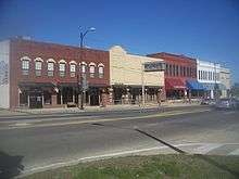
Marianna is an official Florida Main Street town. The downtown area has been restored to look as it did many years ago. The downtown area includes the Marianna Historic District, with a number of antebellum homes.
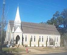
Florida Caverns State Park is located near the town. There is also cave diving in underwater Blue Springs. St. Luke's Episcopal Church and cemetery are state landmarks following a principal role in the U.S. Civil War battle of Marianna in 1864. Neal's Landing on the Chattahoochee River is not far from Marianna and is a fishing and camping area. Neal's Landing is where the old Indian village of Ekanchattee once existed. The Chipola River is a source of recreation during all but the winter months.
Notable people
- Monnie T. Cheves, former assistant to the president of Chipola College, member of the Louisiana House of Representatives from 1952 to 1960[9]
- Bobby Goldsboro, pop and country singer-songwriter, was born in Marianna.[10]
- Claude Neal, Black man lynched by racist Southern whites in 1934.
- Rick Pearson, professional golfer.
- Wankard Pooser, politician
- Jim Sorey, American football player
- John Milton, Governor of Florida during the Civil War
- David Hart, actor, most widely known as Officer Parker Williams on the TV show In The Heat of the Night
- Sam E. Parish, 8th Chief Master Sergeant of the Air Force
See also
References
- 1 2 "American FactFinder". United States Census Bureau. Retrieved 2008-01-31.
- ↑ "US Board on Geographic Names". United States Geological Survey. 2007-10-25. Retrieved 2008-01-31.
- ↑ "Find a County". National Association of Counties. Retrieved 2011-06-07.
- ↑ Luscombe, Richard (6 February 2015). "'Rape Dungeon' Allegations Emerge in Abuse Report on Dozier School for Boys". The Guardian. Retrieved 7 February 2015.
- ↑ "US Gazetteer files: 2010, 2000, and 1990". United States Census Bureau. 2011-02-12. Retrieved 2011-04-23.
- ↑ "Annual Estimates of the Resident Population for Incorporated Places: April 1, 2010 to July 1, 2015". Retrieved July 2, 2016.
- ↑ "Census of Population and Housing". Census.gov. Retrieved June 4, 2015.
- ↑ Walter L. Smith, The Magnificent Twelve: Florida's Black Junior Colleges, Winter Park, Florida, FOUR-G Publishers, 1994, ISBN 1885066015, pp. 211-225.
- ↑ "In Memoriam: Monnie T. Cheves". Alexandria, Louisiana: Alexandria Daily Town Talk. August 17, 1988. p. D3. Retrieved September 9, 2014.
- ↑ Whitburn, Joel (1996). The Billboard Book of Top 40 Country Hits, p.128-129. ISBN 0-8230-7632-6.
http://dos.myflorida.com/florida-facts/florida-history/florida-governors/john-milton/
External links
![]() Media related to Marianna, Florida at Wikimedia Commons
Media related to Marianna, Florida at Wikimedia Commons
Municipalities and communities of Jackson County, Florida, United States | ||
|---|---|---|
| Cities | 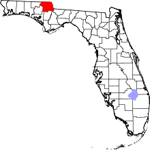 | |
| Towns | ||
| Unincorporated communities | ||