Druid Hills, Georgia
| Druid Hills | |
|---|---|
| CDP and neighborhood of Atlanta | |
|
Centers for Disease Control and Prevention headquarters | |
 Location in DeKalb County and the state of Georgia | |
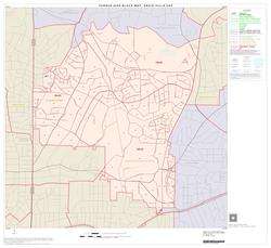 Druid Hills CDP, unincorporated DeKalb County | |
| Coordinates: 33°47′14″N 84°19′34″W / 33.78722°N 84.32611°WCoordinates: 33°47′14″N 84°19′34″W / 33.78722°N 84.32611°W | |
| Country | United States |
| State | Georgia |
| County | DeKalb |
| Area | |
| • Total | 4.2 sq mi (11 km2) |
| • Land | 4.2 sq mi (10.9 km2) |
| • Water | 0 sq mi (0.1 km2) |
| Elevation | 912 ft (278 m) |
| Population (2010) | |
| • Total | 14,568 |
| • Density | 3,500/sq mi (1,300/km2) |
| (CDP only) | |
| Time zone | Eastern (EST) (UTC-5) |
| • Summer (DST) | EDT (UTC-4) |
| ZIP code | 30333 |
| Area code(s) | 404 |
| FIPS code | 13-24264[1] |
| GNIS feature ID | 0331589[2] |

Druid Hills is a community which includes both a census-designated place (CDP) in unincorporated DeKalb County, Georgia, United States, as well as a neighborhood of the city of Atlanta. The CDP's population was 14,568 at the 2010 census.[3] The CDP contains the main campus of Emory University and the Centers for Disease Control and Prevention (CDC). The Atlanta-city section of Druid Hills is one of Atlanta's most affluent neighborhoods with a median household income in excess of $238,500 (making it the ninth most affluent, per that metric).[4]
History
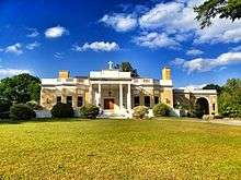
The planned community was initially conceived by Joel Hurt, and developed with the effort of Atlanta's leading families, including Coca-Cola founder Asa Candler. It contains some of Atlanta's historic mansions from the late 19th and early 20th century. Druid Hills includes the main campus of Emory University, which relocated to Atlanta in 1914.
Druid Hills was designed by Frederick Law Olmsted and was one of his last commissions. A showpiece of the design was the string of parks along Ponce de Leon Avenue, which was designated as Druid Hills Parks and Parkways and listed on the National Register of Historic Places on April 11, 1975. The remainder of the development was listed on the Register as the Druid Hills Historic District on October 25, 1979.[5][6] Later the Park and Parkways district was consolidated into the Druid Hills Historic District. The other historic districts in Druid Hills are:
- Emory University District, added in 1975
- University Park-Emory Highlands-Emory Estates Historic District, added in 1998
- Emory Grove Historic District, added in 2000.[7]


Geography
Druid Hills is located at 33°47′14″N 84°19′34″W / 33.78722°N 84.32611°W (33.787205, -84.325974).[8]
According to the United States Census Bureau, the CDP has a total area of 4.2 square miles (11 km2), of which 0.04 square miles (0.10 km2), or 0.48%, is water. The CDP's northern boundary is the South Fork of Peachtree Creek; the CSX track and the Decatur city limits are the eastern boundary; the DeKalb County line is the western boundary; and the southern boundary is the Atlanta city limit.
The Druid Hills neighborhood of Atlanta is bounded by the Druid Hills CDP (i.e. unincorporated DeKalb County) on the north and east; the Morningside/Lenox Park, Virginia-Highland and Poncey-Highland neighborhoods of Atlanta on the west; and the Candler Park neighborhood of Atlanta on the south.
The Chelsea Heights neighborhood is located in the eastern part of the CDP at the Decatur border, and participates in the Druid Hills Civic Association.
Demographics
As of the census[1] of 2000, there were 12,742 people, 4,627 households, and 2,040 families residing in the CDP. The population density was 3,040.4 people per square mile (1,174.1/km²). There were 4,830 housing units at an average density of 1,152.6/sq mi (445.1/km²). The racial makeup of the CDP was 84.15% White, 6.0% African-American, 0.16% Native American, 7.34% Asian, 0.07% Pacific Islander, 0.64% from other races, and 1.64% from two or more races. Hispanic or Latino of any race were 2.43% of the population.
There were 4,627 households out of which 18.9% had children under the age of 18 living with them, 37.5% were married couples living together, 4.7% had a female householder with no husband present, and 55.9% were non-families. 37.4% of all households were made up of individuals and 10.0% had someone living alone who was 65 years of age or older. The average household size was 2.06 and the average family size was 2.80.
In the CDP the population was spread out with 13.0% under the age of 18, 30.2% from 18 to 24, 30.7% from 25 to 44, 16.5% from 45 to 64, and 9.6% who were 65 years of age or older. The median age was 28 years. For every 100 females there were 91.5 males. For every 100 females age 18 and over, there were 88.2 males.
The median income for a household in the CDP was $62,953, and the median income for a family was $106,196. Males had a median income of $57,017 versus $45,458 for females. The per capita income for the CDP was $34,829. About 2.3% of families and 7.7% of the population were below the poverty line, including 3.5% of those under age 18 and 4.2% of those age 65 or over.

Economy

Emory University, including its hospitals, is the third largest employer in Metro Atlanta as of 2007/8.[9] The CDC is also an employer of note.
Commercial areas include Emory Village, a small node first developed in the 1920s at the terminus of the streetcar line to Emory. A revitalization of the area was completed in 2011 with new sidewalks, street furniture and two new roundabouts.[10][11]
The other, larger commercial areas fall just outside the community's boundaries, such as the Clairmont Road corridor in North Decatur, the Sage Hill shopping center in Atlanta's Morningside/Lenox Park, and the Ponce de Leon Avenue corridor just west of Druid Hills in Atlanta's Poncey-Highland/Virginia-Highland.
Arts and culture

Druid Hills is home to The Atlanta Boy Choir on S. Ponce de Leon Ave. and Callanwolde Fine Arts Center, housed in the Gothic-Tudor style former estate of Charles Howard Candler, president of Coca-Cola and eldest son of Asa Griggs Candler, Coca-Cola's co-founder.
Parks
- Baker Woodland, Emory University, between Fishburne Dr. & South Kilga Cir. Forest of oak, tulip poplar, beech, and hickory trees - contains over 100 plant species.
- Burbanck Park, Oxford Rd. & Clifton Rd. 1.2-acre (4,900 m2) natural park which borders Peavine Creek. It is named after Madeline and William Burbanck, Emory University professors who owned the property.[12]
- Fernbank Forest, Fernbank Museum of Natural History.[13]
- Fernbank School Park, 157 Heaton Park Dr. This DeKalb County 12-acre (49,000 m2) park is located west of the CSX railroad tracks. It includes a multi-use field and court, playground, picnic area and walking trails.
- Hahn Woods, Emory University, Houston Mill Rd. (at South Peachtree Creek). Nature preserve with trail and viewing platform over the creek.
- Medlock Park North Druid Hills subdivision, Nine little league baseball fields with concessions, playground and a running/cycling trail which follows Nancy Creek.
- Olmsted Linear Park, Druid Hills, Ponce de Leon Ave. 50 acres (200,000 m2) of six distinct parks, strung along Ponce de Leon Avenue like a necklace. They were designed by Frederick Law Olmsted in the late 19th Century. Each of the six parks has its own name: Deepdene, Dellwood, Shadyside, Springdale, Virgilee and Oak Grove (formerly Brightwood).[14]
- Wesley Woods Forest, Emory University.
- Princeton Way Park, a small neighborhood park that is surrounded by the interior homes of Princeton Way. The park is equipped with picnic tables, swings, slides, a sandbox, short walking trails, and an informal baseball setup.
Government
The neighborhood organization, the Druid Hills Civic Association (DHCA), gives input to two authorities since the community is divided between the city of Atlanta and unincorporated territory in DeKalb County.
The Atlanta part is an official recognized neighborhood of Atlanta, which in turn is part of NPU N. Officially, DHCA exercises its input into planning and other city processes by giving input to the NPU.[15]
DeKalb County does not have an officially designated role for the community within the county government in the way the City of Atlanta does (though there are five large geographic districts for the election of county commissioners), so the DHCA gives input to the unitarian county government in Decatur.[16]
The United States Postal Service operates the Druid Hills Post Office at 1799 Briarcliff Road NE in the North Druid Hills CDP in unincorporated DeKalb.[17][18] The Centers for Disease Control and Prevention's main offices are located in the CDP.[19][20][21]
Infrastructure
Transportation
Public bus transportation is provided by the Metropolitan Atlanta Rapid Transit Authority, while Emory University runs an extensive fleet of shuttles, called the "Cliff".[22]
Education
Primary and secondary schools
Public schools
The CDP is served by the DeKalb County School System. Residents are zoned to Fernbank Elementary School (in the Druid Hills CDP[20]), Druid Hills Middle School (in the North Decatur CDP[23]), and Druid Hills High School (in the Druid Hills CDP[20]).[24]
Private schools
The Paideia School is a nearby preK–12 private school in the city of Atlanta.
Colleges and universities
Emory University is a private university located in the Druid Hills CDP.[20]
Places of worship
Synagogues are located in adjacent Virginia-Highland, Morningside/Lenox Park and North Druid Hills, the latter having one of the largest concentrations of Orthodox Jews in Metro Atlanta.
- Churches
- Atlanta Metropolitan Cathedral, 999 Briarcliff Rd.
- Atlanta Primitive Baptist Church, 1367 S Ponce De Leon Ave.
- Emory Presbyterian Church (PCUSA), 1886 N Decatur Rd.
- Church of the Epiphany (AEC), 2089 Ponce De Leon Ave.
- Druid Hills Baptist Church (CBF), Ponce de Leon Ave. & N. Highland Ave.
- Druid Hills Presbyterian Church (PCUSA), 1026 Ponce De Leon Ave.
- Druid Hills United Methodist Church (UMC), Ponce de Leon Ave. & Briarcliff Rd. - built 1955, Ivey and Crook, architects
- Glenn Memorial United Methodist Church (UMC), 1660 N. Decatur Rd.
- The Church of Jesus Christ of Latter-Day Saints (Mormon), 1450 Ponce De Leon Ave.
- St. Elias Antiochian Orthodox Church, 2045 Ponce de Leon Ave.
- Saint John's Lutheran Church (ELCA), 1410 Ponce de Leon Ave.
- St. John Chrysostom Melkite Church, 1428 Ponce De Leon Ave.
Notable residents
- Cully Cobb, founder of the Cobb Institute of Archaeology at Mississippi State University
See also
Bibliography
- Bryant, James C. Druid Hills Golf Club in Atlanta: The Story and the People, 1912–1997. Atlanta, Ga.: Druid Hills Golf Club, 1998
- Hartle, Robert, Jr. Atlanta's Druid Hills: A Brief History. The History Press, June 27, 2008.
References
- 1 2 "American FactFinder". United States Census Bureau. Retrieved 2008-01-31.
- ↑ "US Board on Geographic Names". United States Geological Survey. 2007-10-25. Retrieved 2008-01-31.
- ↑ "Race, Hispanic or Latino, Age, and Housing Occupancy: 2010 Census Redistricting Data (Public Law 94-171) Summary File (QT-PL), Druid Hills CDP, Georgia". U.S. Census Bureau, American FactFinder 2. Retrieved October 28, 2011.
- ↑ Stephen R. Higley, PhD. "Neighborhood Summary By Metro Area". Higley1000.com. Retrieved 13 October 2014.
- ↑ National Park Service (2009-03-13). "National Register Information System". National Register of Historic Places. National Park Service.
- ↑ Archived October 17, 2013, at the Wayback Machine.
- ↑ Archived October 17, 2013, at the Wayback Machine.
- ↑ "US Gazetteer files: 2010, 2000, and 1990". United States Census Bureau. 2011-02-12. Retrieved 2011-04-23.
- ↑ "Metro Atlanta Chamber of Commerce : 2007/2008" (PDF). Metroatlantachamber.com. Retrieved 13 October 2014.
Figures are for HQ only, not retail stores
. - ↑ ""Revitalization Plan", Alliance to Improve Emory Village" (PDF). Emoryvillage.org. Retrieved 13 October 2014.
- ↑ "David Payne, "Emory Village roundabout project begins", Emory Report, August 23, 2010". Emory.edu. Retrieved 13 October 2014.
- ↑ Clifton Community Partnership. "Burbanck Park". Clifton Community Partnership. Cool Dog Interactive. Retrieved 2014-06-30.
- ↑ Fernbank Forest
- ↑ Olmsted Linear Park Alliance. "The Olmsted Linear Park Tour". atlantaolmstedpark.org. Olmsted Linear Park Alliance. Retrieved 2014-06-30.
- ↑ "Druid Hills Civic Association". Druid Hills Civic Association. Retrieved 13 October 2014.
- ↑ "DeKalb County website". Co.dekalb.ga.us. Retrieved 13 October 2014.
- ↑ "Post Office Location - DRUID HILLS." United States Postal Service. Retrieved on May 5, 2009.
- ↑ "North Druid Hills CDP, GA." United States Census Bureau. Retrieved on May 5, 2009.
- ↑ "Centers for Disease Control and Prevention". Cdc.gov. Retrieved 13 October 2014.
- 1 2 3 4 "Druid Hills CDP, GA." United States Census Bureau. Retrieved on May 5, 2009.
- ↑ Kessler, John. "CDC flu chief: ‘Mother Nature rolling the dice’." Atlanta Journal-Constitution. Sunday May 3, 2009. Retrieved on February 5, 2011. "The second bolt of lightning struck two miles south of the CDC, in Druid Hills."
- ↑ "Cliff Shuttles, Emory University". Transportation.emory.edu. Retrieved 13 October 2014.
- ↑ "American FactFinder". Factfinder.census.gov. Retrieved 13 October 2014.
- ↑ Archived July 11, 2009, at the Wayback Machine.
External links
- Druid Hills Civic Association
- Druid Hills Historic District
- Arbor Atlanta: Hahn Woods
- Wesley Woods Forest
- Emory University Walking Tour
- Emory Village historic preservation incl. history of Emory Village
|  | |||||||
|
| ||||||||
| ||||||||
Municipalities and communities of DeKalb County, Georgia, United States | ||
|---|---|---|
| Cities | 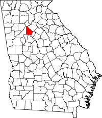 | |
| CDPs | ||
| Neighborhoods and unincorporated communities | ||
| Ghost town | ||
| Footnotes | ‡This populated place also has portions in an adjacent county or counties | |
| Topics | |
|---|---|
| Lists by states |
|
| Lists by insular areas | |
| Lists by associated states | |
| Other areas | |
| |
