Georgia State Route 13
| ||||
|---|---|---|---|---|
 | ||||
| Route information | ||||
| Maintained by GDOT | ||||
| Length: | 49.5 mi[1] (79.7 km) | |||
| Major junctions | ||||
| South end: |
| |||
|
| ||||
| North end: |
| |||
| Location | ||||
| Counties: | Fulton, DeKalb, Gwinnett, Hall | |||
| Highway system | ||||
| ||||

State Route 13 (SR 13) is a 49.5-mile-long (79.7 km) state highway in the north-central part of the U.S. state of Georgia, that travels through portions of Fulton, DeKalb, Gwinnett, and Hall counties. It begins at West Peachtree Street and Spring Street (U.S. Route 19 (US 19)/SR 9) just to the north of 17th Street in the northern part of Midtown Atlanta. The section near Downtown Atlanta is a full freeway, from its south end to Sidney Marcus Boulevard. This was the original alignment of Interstate 85 (I-85; Northeast Expressway) through northeast Atlanta. The route ends at Jesse Jewell Parkway (SR 369) in Gainesville. The name changes from Buford Highway to Atlanta Highway at the northeast city limits of Buford. The stretch between the DeKalb–Fulton county line and several miles northeast of I-285 is often regarded as a community (see Buford Highway).
SR 13 once continued northeast past Gainesville, roughly along present SR 365, to the South Carolina state line on US 123.
Route description
Spring Street/West Peachtree Street
SR 13 begins at an intersection with US 19/SR 9, which are aligned onto two one-way streets, Spring Street southbound and West Peachtree Street northbound. The route starts heading west but curves around to the northeast along a section of freeway adjacent to I-85. A half-interchange provides a shortcut for southbound SR 13 traffic to Peachtree Street and from Peachtree to northbound SR 13. The connection provides a savings of 3⁄4 mile (1.2 km) by allowing vehicles to avoid the southernmost section of SR 13.[2][3]
All of SR 13, from its southern terminus to the DeKalb–Gwinnett county line, is included as part of the National Highway System, a system of roadways important to the nation's economy, defense, and mobility.[4]
Buford Highway
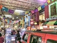
In the Atlanta metro area, Buford Highway is a linear community made up of multi-ethnic suburban neighborhoods and shopping centers. Similar to other sun belt cities, immigrants who relocated to Atlanta in the 20th and 21st centuries went straight to the suburbs, where residential and commercial real estate was affordable and where many second-generation immigrant communities were already established. Along Buford Highway, there are few wholly distinct ethnic areas. The more than 1,000 immigrant-owned businesses are owned by and patronized by a wide variety of ethnic groups,[5][6] notably Korean, Mexican, Chinese and Vietnamese, and also Indian/South Asian, Central American, Somalis and Ethiopian. The DeKalb County Chamber of Commerce calls the area the "International Corridor."[7]

The Buford Highway community is home to one of the highest concentration of foreign-born residents in the country, notably Mexican, Central American, Chinese, Korean and Vietnamese. The area attracted many Latino workers during the construction boom that preceded the 1996 Olympic Games. Asian business owners were attracted to the stretch of highway by cheap leases and reliable traffic flow.[8]

Buford Highway is, in most places in the corridor, a seven-lane highway with no median and few sidewalks, a situation which is grossly mismatched with the heavy pedestrian traffic along and across the highway.
Most properties along the corridor are in the form of strip malls, retail businesses surrounded by large parking lots, and large apartment complexes. The largest strip malls are the 466,000-square-foot (43,300 m2) Northeast Plaza, 355,000-square-foot (33,000 m2) Plaza Fiesta and the Buford Highway Farmers Market complex.
SR 13 is referred to as Buford Highway, an international community north of Atlanta, spanning multiple counties including Fulton, Dekalb and Gwinnett. The area generally spans along and on either side of a stretch of SR 13 in DeKalb County. It begins just north of Midtown Atlanta, continues northeast through the towns of Brookhaven, Chamblee, and Doraville, and ends 1.3 miles (2.1 km) northeast of the Perimeter (I-285) at the DeKalb–Gwinnett county line. This area contains a muli-ethnic community which is also officially referred to as the "International Village". It is also referred to as Atlanta's Chinatown, Koreatown, and Little Saigon blended with the Latin American culture such as Little Mexico.
Atlanta Highway
Going north of Buford, the name changes from Buford Highway to Atlanta Highway and continues to SR 369 in Gainesville.
History
Buford Highway originated as a non-descript state roadway connecting Atlanta and points northeast, including the then-railroad towns of Chamblee and Doraville, as well as points farther north. The towns of Doraville, Chamblee, and Norcross had long been home to a blue collar, largely white, lower middle-class population. The highway was characterized by strip mall development, and apartment complexes sprouted up in the 1960s and 1970s.[5] In 1976 the first ethnic restaurant opened, the Havana Sandwich Shop. In the 1980s, immigrants settled in the area due to affordable housing, available public transportation, and proximity to construction jobs in growing Gwinnett County.[9] The area attracted many Latino workers during the construction boom that preceded the 1996 Olympic Games. Asian business owners were attracted to the stretch of highway by cheap leases and reliable traffic flow.[8]
During the 1996 Olympics, Chamblee embraced the growing international character of Buford Highway, while more conservative Doraville resisted it. As the Southern Foodways Alliance reported:
"'Why would we want to attract more immigrants when we got all we want?' asked Doraville mayor Lamar Lang to the press. 'That’s just not our way of life here,' agreed the city council. 'We’re basically Baptists and Methodists and Presbyterians.'"[9]
Accidents
On July 22, 2010 PBS's Need to Know program portrayed the corridor as an example of a high-pedestrian area in suburban America that fails to meet increased demand for walkability due to changing demographics.[10] The program noted that in the previous ten years, 30 people had died and an additional 250 were injured while trying to cross Buford Highway, a rate three times higher than any other road in Georgia. Despite this, there are no plans to improve pedestrian safety in the unincorporated area of the corridor.
Public transportation
Buford Highway is served by MARTA bus route 39 (Lindbergh Center to Doraville) as well as privately run "jitneys", or minibuses.[11] Also, the Doraville MARTA metro rail station is a block away from Buford Highway.
In popular culture
The city of Chamblee, in which part of the Buford Highway community is located, is sometimes referred to as "Chambodia" due to its high Asian population and the concentration of Asian restaurants along Buford Highway in Chamblee. A chapter of Tom Wolfe's novel A Man in Full is titled "Chambodia".[12][13]
Major intersections
| County | Location | mi | km | Destinations | Notes |
|---|---|---|---|---|---|
| Fulton | Atlanta | 0.00 | 0.00 | Freeway section begins | |
| 0.42 | 0.68 | Southbound exit and northbound entrance | |||
| 1.38 | 2.22 | Southbound exit and northbound entrance; I-85 exit 86 | |||
| 2.01 | 3.23 | Armour Drive / Monroe Drive to Piedmont Road south | |||
| 2.18 | 3.51 | Northbound exit and southbound entrance | |||
| 2.87 | 4.62 | Northbound exit and southbound entrance; I-85 exit 86 | |||
| 3.17 | 5.10 | north end of freeway | |||
| DeKalb | Brookhaven | 4.35 | 7.00 | ||
| 6.69 | 10.77 | South end of US 23 overlap | |||
| Doraville | |||||
| 10.55 | 16.98 | I-285 exit 32 | |||
| Gwinnett | Gwinnett Village–Norcross line | 14.27 | 22.97 | ||
| Norcross | 15.70 | 25.27 | |||
| Duluth | interchange | ||||
| 21.04 | 33.86 | ||||
| Sugarloaf Parkway | |||||
| Suwanee | 27.18 | 43.74 | |||
| Sugar Hill–Buford line | 31.29 | 50.36 | North end US 23 overlap | ||
| Hall | Buford | 35.78 | 57.58 | ||
| Oakwood | 44.33 | 71.34 | |||
| 44.58 | 71.74 | ||||
| 45.19 | 72.73 | I-985 exit 17 | |||
| Gainesville | 49.53 | 79.71 | |||
1.000 mi = 1.609 km; 1.000 km = 0.621 mi
| |||||
Bannered route
| |
|---|---|
| Location: | Doraville |
| Length: | 1.0 mi[14] (1.6 km) |
State Route 13 Connector (SR 13 Connector) is a 1-mile-long (1.6 km) connector route that connects US 23/SR 13 (Buford Highway NE) to SR 141 (Peachtree Industrial Boulevard) in Doraville, within DeKalb County. The entire route travels along Motors Industrial Way, a four-lane divided highway with a grassy median. The route is separated from the inner lanes of Interstate 285 (I-285) by a Jersey barrier.
SR 13 Connector is not part of the National Highway System, a system of roadways important to the nation's economy, defense, and mobility.[4]
The entire route is in Doraville, DeKalb County.
| mi[1] | km | Destinations | Notes | ||
|---|---|---|---|---|---|
| 0.0 | 0.0 | Southern terminus | |||
| 1.0 | 1.6 | Northern terminus | |||
| 1.000 mi = 1.609 km; 1.000 km = 0.621 mi | |||||
See also
-
.svg.png) Georgia (U.S. state) portal
Georgia (U.S. state) portal -
 U.S. Roads portal
References
- 1 2 Google (August 24, 2013). "Route of SR 13" (Map). Google Maps. Google. Retrieved August 24, 2013.
- ↑ Google (July 12, 2011). "SR 13 to Peachtree via SR 13" (Map). Google Maps. Google. Retrieved July 12, 2011.
- ↑ Google (July 12, 2011). "SR 13 to Peachtree via exit" (Map). Google Maps. Google. Retrieved July 12, 2011.
- 1 2 "National Highway System: Georgia" (PDF). United States Department of Transportation. October 1, 2012. Retrieved August 25, 2013.
- 1 2 "What Is Buford Highway?". Buford Highway Project. Retrieved June 28, 2011.
- ↑ "Buford Highway" (PDF). Creative Loafing Ultimate Neighborhood Guide. Atlanta, Georgia: Creative Loafing Atlanta. 39 (48). March 31 – April 6, 2011.
- ↑ "Visitor Information". DeKalb County Chamber of Commerce. Archived from the original on May 25, 2009. Retrieved June 28, 2011.
- 1 2 Moreno Gonzales, John (March 10, 2009). "Immigrants along Buford Highway face mixed signals". The Atlanta Journal-Constitution. Associated Press. Retrieved March 10, 2009.
- 1 2 "City Guide Atlanta/Buford Highway" (PDF). Southern Foodways Alliance. Retrieved June 28, 2011.
- ↑ Larson, John (Correspondent), Moore, Fae (Producer) (July 22, 2010). Dangerous Crossing. PBS. Retrieved July 29, 2010.
- ↑ "Response to Recent Conversation", '"Atlanta Journal-Constitution, August 26, 2013
- ↑ Neal Becton, "Atlanta's 'Chambodia,' a 'Burb With a Global Flavor", Washington Post, April 18, 1999
- ↑ Cliff Bostock, We heart Chambodia", Creative Loafing, January 8, 2004
- ↑ Google (August 25, 2013). "Route of SR 13 Connector" (Map). Google Maps. Google. Retrieved August 25, 2013.
External links
-
 Media related to Georgia State Route 13 at Wikimedia Commons
 - Georgia Roads (Routes 1 - 20)