Yana Mayu (Potosí)
For the river in the Ancash Region, Peru, see Yanamayu.
| Yana Mayu | |
|---|---|
 Yana Mayu Location in Bolivia | |
| Highest point | |
| Elevation | 4,797 m (15,738 ft) [1] |
| Coordinates | 19°42′30″S 65°36′50″W / 19.70833°S 65.61389°WCoordinates: 19°42′30″S 65°36′50″W / 19.70833°S 65.61389°W |
| Geography | |
| Location |
Bolivia, Potosí Department |
| Parent range | Andes, Potosí mountain range |
Yana Mayu (Quechua yana black, mayu river,[2] "black river") is a 4,797 metres (15,738 ft) high mountain in the Potosí mountain range of the Bolivian Andes. It is located in the Potosí Department, on the border of the Cornelio Saavedra Province, Chaqui Municipality, and the José María Linares Province, Puna Municipality. It is situated northeast of Jatun Kunturiri. The lakes named Kimsa Qucha ("three lakes", Quimsa Khocha) and Q'ara Qucha ("bare lake", Khara Khocha) lie at its feet.[1][3]
References
Capital: Potosí | ||
| Provinces | 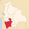 | |
| Municipalities (and seats) |
| |
This article is issued from Wikipedia - version of the 12/7/2015. The text is available under the Creative Commons Attribution/Share Alike but additional terms may apply for the media files.