Weißbach, Baden-Württemberg
For the town in Austria, see Weißbach bei Lofer.
| Weißbach | ||
|---|---|---|
 | ||
| ||
 Weißbach | ||
Location of Weißbach within Hohenlohekreis district 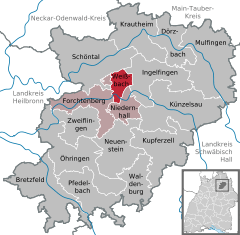
 | ||
| Coordinates: 49°18′N 9°36′E / 49.300°N 9.600°ECoordinates: 49°18′N 9°36′E / 49.300°N 9.600°E | ||
| Country | Germany | |
| State | Baden-Württemberg | |
| Admin. region | Stuttgart | |
| District | Hohenlohekreis | |
| Municipal assoc. | Mittleres Kochertal | |
| Government | ||
| • Mayor | Rainer Züfle | |
| Area | ||
| • Total | 12.77 km2 (4.93 sq mi) | |
| Population (2015-12-31)[1] | ||
| • Total | 2,039 | |
| • Density | 160/km2 (410/sq mi) | |
| Time zone | CET/CEST (UTC+1/+2) | |
| Postal codes | 74679 | |
| Dialling codes | 07947 | |
| Vehicle registration | KÜN | |
| Website | www.gemeinde-weissbach.de | |

Weißbach is a town in the district of Hohenlohe in Baden-Württemberg in Germany.
Geography
Weißbach is situated in the middle of the Kochertal valley where the Langenbach flows into the Kocher. Its parts stretch from 200 to 430 meters above sea level and it is 10 km west of its district town Künzelsau. It consists of the formerly independent villages Weißbach and Crispenhofen and the two hamlets Halberg and Guthof.
Economy and Infrastructure
Companies
- Konrad Hornschuch AG (Manufacturer of d-c-fix foils and of skai-artificial leather)
Education
Weißbach has a primary school and two Kindergarten run by the Protestant church and one library.
Sport
Weißbach has a gymnasium and in Crispenhofen there is a tennis court.
Towns and municipalities in Hohenlohe (district) | ||
|---|---|---|
References
This article is issued from Wikipedia - version of the 5/18/2015. The text is available under the Creative Commons Attribution/Share Alike but additional terms may apply for the media files.