Stavešinski Vrh
| Stavešinski Vrh | |
|---|---|
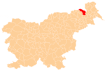
 Stavešinski Vrh Location in Slovenia | |
| Coordinates: 46°37′13.82″N 15°59′6.74″E / 46.6205056°N 15.9852056°ECoordinates: 46°37′13.82″N 15°59′6.74″E / 46.6205056°N 15.9852056°E | |
| Country |
|
| Traditional region | Styria |
| Statistical region | Mura |
| Municipality | Gornja Radgona |
| Area | |
| • Total | 2.04 km2 (0.79 sq mi) |
| Elevation | 284.1 m (932.1 ft) |
| Population (2002) | |
| • Total | 167 |
| [1] | |
Stavešinski Vrh (pronounced [ˈstaːʋɛʃinski ˈʋəɾx]) is a settlement north of Stavešinci in the Municipality of Gornja Radgona in northeastern Slovenia.[2]
There is a small chapel-shine in the central part of the village. It was built in 1814.[3]
References
External links
| Settlements | Administrative centre: Gornja Radgona
|  |
|---|---|---|
| Landmarks |
| |
| Notable people |
| |
This article is issued from Wikipedia - version of the 12/29/2015. The text is available under the Creative Commons Attribution/Share Alike but additional terms may apply for the media files.