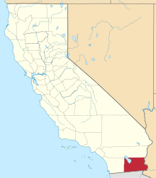
Sandia, California
Coordinates: 32°53′08″N 115°24′21″W / 32.88556°N 115.40583°W
| Sandia | |
|---|---|
| Unincorporated community | |
 Sandia  Sandia Location in California | |
| Coordinates: 32°53′08″N 115°24′21″W / 32.88556°N 115.40583°W | |
| Country | United States |
| State | California |
| County | Imperial County |
| Elevation[1] | -82 ft (-25 m) |
Sandia is an unincorporated community in Imperial County, California.[1] It is located on a former branch of the Southern Pacific Railroad 5.25 miles (8.4 km) north-northwest of Holtville,[2] at an elevation of 82 feet (25 m) below sea level.[1]
References
This article is issued from Wikipedia - version of the 7/5/2016. The text is available under the Creative Commons Attribution/Share Alike but additional terms may apply for the media files.