Salyan District, Nepal
| Salyān Jillā सल्यान जिल्ला | |
|---|---|
| District | |
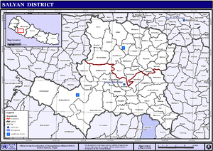
 Salyan (red) | |
| Country | Nepal |
| Region | {{{region}}} |
| Zone | Rapti (darker grey) |
| Headquarters | Salyan |
| Area | |
| • Total | 1,462 km2 (564 sq mi) |
| Population (2011[1]) | |
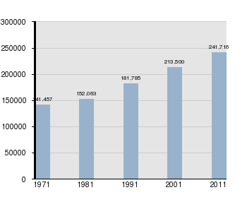
| • Total | 241,716 |
| • Density | 170/km2 (430/sq mi) |
| Time zone | NPT (UTC+5:45) |
| Website |
ddcsalyan |
Salyan District (Nepali: सल्यान जिल्ला![]() Listen ), is a "hill" district some 320 km west of Kathmandu in Province No. 6 in midwestern Nepal. Salyan covers an area of 1,462 km² with a population of 213,500 in 2001 and 241,716 in 2011. The district's administrative center is named Salyan or Salyan Khalanga.
Listen ), is a "hill" district some 320 km west of Kathmandu in Province No. 6 in midwestern Nepal. Salyan covers an area of 1,462 km² with a population of 213,500 in 2001 and 241,716 in 2011. The district's administrative center is named Salyan or Salyan Khalanga.
The district is known for its Hindu temples including Shiva temples in Chhayachhetra and Laxmipur, and the Devi temple at Khairabang in Hiwalcha VDC, one of nine in Nepal.
History
Salyan was one of the Baise Rajya (Nepali: बाइसे राज्य) -- a confederation of 22 petty kingdoms in the Karnali (Ghagra) region. About 1760 AD all these kingdoms were annexed by the Shah Dynasty during the unification of Nepal.
Etymology
Salyan derives from Nepali: सल्लो, sallo meaning pine tree or conifer.[2]
Geography and climate
Although Salyan is considered a hill district, its southwest salient is actually outside the Pahari-inhabited hill region, in the lower Siwalik Hills that are more an extension of the Terai.
The Babai River flows through the southwestern Siwaliks section after draining Dang Valley. A tributary Sharad Khola drains the eastern half of Salyan's hill region—including the district center, then exits these hills by cutting through the Mahabharat Range to its confluence with the Babai. The western half of Salyan's hill region is drained by the Bheri.
| Climate zone[3] | Elevation range | % of area |
|---|---|---|
| Upper tropical | 300 to 1,000 meters 1,000 to 3,300 ft. |
28.6% |
| Subtropical | 1,000 to 2,000 meters 3,300 to 6,600 ft. |
68.3% |
| Temperate | 2,000 to 3,000 meters 6,400 to 9,800 ft. |
3.0% |
Population by census 1971–2011[4][5]
Village Development Committees (VDCs)
- Badagaun, Bafukhola, Bajh Kanda, Bame Banghad, Bhalchaur
- Chande, Chhayachhetra
- Damachaur, Dandagaun, Darmakot, Devasthal, Jhajhari Pipal, Dhakadam, Dhanwang
- Hiwalcha
- Jhimpe, Jimali
- Kabhrechaur, Kajeri, Kalagaun, Kalimati Kalche, Kalimati Rampur, Kavra, Khalanga, Korbang Jhimpe, Kotbara, Kotmala, Kubhinde
- Laxmipur, Lekhpokhara
- Majh Khanda, Marke, Marmaparikanda, Mulkhola
- Nigalchula
- Phalawang, PipalNeta
- Rim
- Saijuwal Takura, Sarpani Garpa, Sibaratha, Siddheswar, Sinwang, Suikot, Syanikhal
- Tharmare, Tribeni
Maps
- Besides the United Nations/Nepal map of districts and VDCs shown above, their Map Centre[6] has a downloadable PDF version adding municipalities, roads and water detail:
- "Salyan District" (PDF) (Map). Retrieved Feb 6, 2014. Missing or empty
|title=(help)
- "Salyan District" (PDF) (Map). Retrieved Feb 6, 2014. Missing or empty
- From 1992 to 2002 a definitive series of large scale topographic maps were surveyed and published through a joint project by Government of Nepal Survey Department[7] and Finland's Ministry for Foreign Affairs contracting through the FinnMap consulting firm.[8] Japan International Cooperation Agency[9] substituted for FinnMap in Lumbini Zone.
- Topographic sheets at 1:25,000 scale covering 7.5 minutes latitude and longitude map the Terai and Middle Mountains. Less populated high mountain regions are on 15 minute sheets at 1:50,000. JPG scans can be downloaded here:[10] These sheets cover Salyan District:
- 2881 08D "Bajedichaur" (1999)
- 2881 11D "Chisapani Mulatati" (1997)
- 2881 12A "Mehelkuna" (1999)
- 2881 12B "Botechaur" (1999)
- 2881 12C "Ghuiyabari" (1998)
- 2881 12D "Baluwa" (1998)
- 2881 16A "Dhakeri" (1997)
- 2881 16B "Dhobaghat" (1997)
- 2882 05A "Karkigau" (1999)
- 2882 05C "Salli Bajar" (1999)
- 2882 05D "Swikot" (1999)
- 2882 06C "Pharulachaur" (1999)
- 2882 06D "Simruth" (1999)
- 2882 09A "Kubhinde Daha" (1999)
- 2882 09B "Khalanga" (1999)
- 2882 09C "Suketal" (1999)
- 2882 09D "Shitalpati" (1998)
- 2882 10A "Tharmare" (1999)
- 2882 10B "Sukhaodar" (1999)
- 2882 10C "Luham" (1998)
- 2882 10D "Nerpa" (1999)
- 2882 13A "Hamsapur" (1998)
- 2882 13B "Panchakule" (1998)
- 2882 14A "Tulsipur" (1999)
- 2882 14B "Dubrin" (1999)
References
- ↑ Central Bureau of Statistics, Kathmandu, Nepal, Jan. 2014
- ↑ Turner, R. L. (Ralph Lilley), Sir (1931). A comparative and etymological dictionary of the Nepali language. London: K. Paul, Trench, Trubner. p. 593.
- ↑ The Map of Potential Vegetation of Nepal - a forestry/agroecological/biodiversity classification system (PDF), . Forest & Landscape Development and Environment Series 2-2005 and CFC-TIS Document Series No.110., 2005, ISBN 87-7903-210-9, retrieved Nov 22, 2013 horizontal tab character in
|series=at position 91 (help) - ↑ "Districts of Nepal". Statoids. Gwillim Law. Retrieved January 23, 2014.
- ↑
- National Population and Housing Census 2011, Volume 3 (PDF). Kathmandu, Nepal: Government of Nepal, Central Bureau of Statistics. January 2014. Retrieved January 23, 2014.
- ↑ "Map Centre". United Nations, Nepal Information Platform. Retrieved February 4, 2014.
- ↑ "Government of Nepal, Survey Department". Retrieved February 4, 2014.
- ↑ "Land Administration & Management, Mapping, Surveying and Aerial Photography, Major Reference Projects" (PDF). FinnMap. Retrieved February 4, 2014.
- ↑ "Japan International Cooperation Agency". Retrieved February 4, 2014.
- ↑ "Nepal-Topo Maps". PAHAR Mountains of Central Asia Digital Dataset. MyPublisher. Retrieved Jan 31, 2014.
- "Districts of Nepal". Statoids.

Coordinates: 28°22′0″N 82°10′0″E / 28.36667°N 82.16667°E
| Wikimedia Commons has media related to Salyan District, Nepal. |