Rudolfsheim-Fünfhaus
| Rudolfsheim-Fünfhaus | ||
|---|---|---|
| 15th District of Vienna | ||
| ||
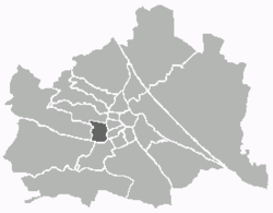 Location of the district within Vienna | ||
| Country | Austria | |
| City | Vienna | |
| Government | ||
| • District Director | Gerhard Zatlokal(SPÖ) | |
| • First Deputy | Claudia Bettina Dobias (SPÖ) | |
| • Second Deputy | Karl Schwing(FPÖ) | |
| • Representation (46 Members) |
SPÖ 22, FPÖ 11, Greens 9, ÖVP 4 | |
| Area | ||
| • Total | 3.92 km2 (1.51 sq mi) | |
| Population (2016-01-01)[1] | ||
| • Total | 78,388 | |
| • Density | 20,000/km2 (52,000/sq mi) | |
| Postal code | A-1150 | |
| Address of District Office |
Gasgasse 8-10 A-1150 Wien | |
| Website |
www.wien.gv.at/bezirke /rudolfsheim-fuenfhaus/ | |
Rudolfsheim-Fünfhaus (German pronunciation: [ˈʀuːdɔlfsˌhaɪ̯m fʏnfˈhaʊ̯s]) is the 15th municipal District of Vienna, Austria (German: 15. Bezirk). It is in central Vienna, west of Innere Stadt.[2]
It borders Neubau and Mariahilf in the east, Meidling and Hietzing in the south, Penzing in the west, and Ottakring in the north. The northern border runs along the Gablenzgasse and eastern border along the Gürtel beltway (Neubaugürtel, Mariahilfer Gürtel and Sechshauser Gürtel). It includes the areas of Rudolfsheim (divided into Braunhirschen, Reindorf and Rustendorf), Fünfhaus and Sechshaus. [2][3]
Geography
Topography
The district area of Rudolfsheim-Fünfhaus was, during the Mesozoic Era, near a sea that retreated 70 million years ago and gradually formed an inland sea. After the final retreat of the sea occurred during the Ice Age, large masses of debris formed from glaciers, mainly from the Danube, but also the Vienna River in the Vienna Basin. In the warm phase, the Danube and Vienna River cut into the land and formed gravel terraces, with the older terraces being at increasing distance from the waters. Rudolfsheim-Fünfhaus is located in the oldest terrace (Laaerbergterrasse) supported by Laaerberg on Gloriette from the melting of the Turks and hill ranges. In this section, the terrace Wiental lies, which was once covered by the melting to Gloriette. Through the ever-receding water levels, the height sections remained for the current district area.
The top soil layer in the district territory consists of a thin layer of loess, which is mixed with limestone and sandstone gravel from the Vienna Woods. Among them are layers of river gravel, mainly quartz, coming from the Alps. Below this gravel are the relics of the freshwater sea that a layer of sand, gravel and Tegel deposited. The district area rises from south to north and from east to west. The lowest area of the district territory is located at the intersection of Sechshauser Belt and Ullmannstraße with an elevation of 184 metres (604 ft). The highest point is at the crossing John Street and Road Hütteldorfer with an elevation of 240.6 metres (789 ft).
Waters
The Vienna River was, in prehistoric times, several hundred meters (a half-mile) wide, and in the Roman period, it was still a wide river with many islands. Even in the Middle Ages and in modern times, the Vienna River has played a dominant role for centuries. On the one hand, the river and its floods repeatedly caused heavy destruction. On the other hand, the river served many people as a source of income, both by fishing, as well as the use of water for industry or the operation of the many watermills. The largest river branch, Mühlbach, followed along Ullmannstraße and Mollardgasse streets. Even smaller streams, which emptied into the Vienna River, were originally in the district area. Today canalised Hollerbach has established itself as a corridor, receiving the name "Hollergasse" lane.
District parts
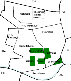
Rudolfsheim-Fünfhaus was formed mainly from the communities of Rudolfsheim, Fünfhaus and Sechshaus, which currently are the 3 Katastralgemeinden sections of the district.
Over time, the district was extended in addition to parts of Gaudenzdorf (between Wienzeile and Diefenbachgasse) and Penzing (between Hollergasse and Winckelmann Street). Sechshaus is located in the southeast between Hollergasse, Sechshauser Straße and Diefenbachgasse. Rudolfsheim is located in the southwest area of the district, Fünfhaus east of it, the origin was in the area Clementinengasse on a path between Gumpendorf and Schmelz. The border between Rudolfsheim and Fünfhaus run along the line Pouthongasse - Schmelzbrücken Ramp - Grenzgasse - Geibelgasse. Originally, Fünfhaus included the area between Mariahilfer Straße, Kenyongasse, and Wimbergergasse Burggasse, but it was released in 1907 on new construction.
The former municipalities of Rudolfsheim and Fünfhaus are also divided into different district parts. Rudolfsheim was formed from the municipalities Rustendorf, Braunhirschen and Reindorf, whose centers were south of Mariahilfer Street. The northern part of Fünfhaus, north from Hütteldorfer road, divided in turn into Schmelz with the University Sports Institute and the Kleingarten area, the adjacent east Nibelungen quarter and the area of Neu-Fünfhaus, which encloses the two regions.
A breakdown of the district area is also in the census-district official statistics, in which the municipality counts are combined. The seven census-districts in Rudolfsheim-Fünfhaus are: Stadthalle, Reithofferplatz, Fünfhaus-Westbahnhof, Sechshaus, Rudolfsheim-Braunhirschen, Rauscherplatz and Schmelz.
Land use
The developed area of Rudolfsheim-Fünfhaus comprises 52.8% (Vienna city-wide 33.3%) of the District area. Nearly 81.0% of the developed area is accounted for by residences, bringing the district in the upper part of the Vienna districts. Farmland includes a share of 8.2% of the area. Cultural, religious, sporting or public buildings share 10.6% of the area. Nearly 33.5% of the district is in traffic/transportation areas. This is the third highest value of a municipality of Vienna.
By contrast, the proportion of grassland in the district is rather small: 12.7%. About half of the green areas are parks, 31.2% attributable to small gardens, with 18.5% as outdoor sports and recreation areas. A final 1.0% is water, i.e. the river bed of the Vienna River.[4]
| Builtspace | Greenspace | Water | Transport areas | |||||||
| 204.04 | 49.16 | 3.68 | 129.46 | |||||||
|---|---|---|---|---|---|---|---|---|---|---|
| Residences | Oper- ations |
Public Facilities | Farms | Parks | Forests | Meadows | Small gardens | Rec. areas | ||
| 165.35 | 16.62 | 21.59 | 31.7 | 24.5 | 0 | 15.34 | 0.21 | 9.11 | ||
History
After the second Turkish siege of Vienna, the villages of Reindorf, Braunhirschen, and Rustendorf arose and were in 1863 combined into the municipality of Rudolfsheim, named after the Crown Prince Rudolf of Austria. In the nineteenth century, the district grew significantly, and in 1890 was incorporated along with nearby communities Fünfhaus and Sechshaus into Vienna proper. The northern and eastern parts of Fünfhaus became the fifteenth district and the area of Rudolfsheim and Sechshaus became the fourteenth district under the name of Rudolfsheim alone. In 1938 Rudolfsheim and Fünfhaus were unified into the 15th district, and the 14th district became the part of the 13th district north of the Wien River. Since 1957, the 15th district has been named Rudolfsheim-Fünfhaus.
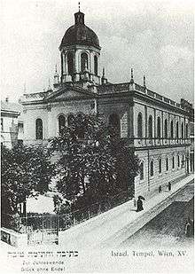
From 1871 to 1938, there had been the synagogue on Turner Street, but during the November Pogrom Kristallnacht, it was destroyed, along with 91 other Viennese synagogues. Only the City Temple in the 1st District survived the night unscathed.
In the 1990s, there were several small changes in district boundaries. In 1992, the boundaries were altered in the area of the Auer-Welsbach Park.[5] In 1995, the district boundaries changed in two sections of the belt,[6][7] and in the field Kendlerstraße, Sporckplatz and Ibsenstraße.[8] The most recent change was marginal in 1996 in the area of Europe square in front of the Western Railway Station.[9] These border changes were not in residential areas, but especially at transport buildings, parks and sports facilities.
Population
 |
Population development
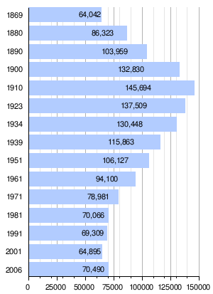
In 1869, the current area covered by the Rudolfsheim-Fünfhaus district already included 64,042 inhabitants, and it was similarly densely populated as it is today. Through the continuous influx of people into the area, the population increased until the beginning of World War I, and had doubled by 1910 at the peak of 145,694 people. Afterwards, a permanent population decline occurred, which was mainly due to higher housing claims. After a historic low of 64,895 inhabitants in 2001, the district population trended to re-grow. Only after the turn of the millennium, did the population in Vienna city-wide tend to grow. At the beginning of 2007, the population stood at 70,490 people in Rudolfsheim-Fünfhaus.
Population structure
The age structure of the district population in 2001 was slightly younger than the average across Vienna. The number of children under 15 years was 15.3%, slightly higher than for Vienna city-wide (14.7%). The proportion of the population from 15 to 59 years stood at 65.8% (Vienna: 63.6%), with the proportion of people over the age of 60 as 19.0% (Vienna: 21.7%), significantly lower than the whole city. The gender distribution was in the district area at 48.2% men and 51.8% women.[10] The number of married people had a share of 40.6%, compared with city-wide at 41.2%, slightly below the average of Vienna.[11][12]
Origin and language
The proportion of foreign district residents in 2006 was 31.8% (Vienna: 19.1%) and was the highest value of a district of Vienna.[13] As in the entire state, the percentage growth to 2001, he worked for 29.2%. The highest proportion of foreigners in 2005 represented approximately 9.6% share of the district population as nationals from Serbia and Montenegro. Another 4.7% were Turkish, 2.5% Polish, 2.3% Croatian, 2.2% Bosnian and 1.1% German citizen. In 2001, nearly 35.2% of the district population was born in Austria. Almost 13.0% stated as a language Serbian, 8.7% Turkish and 5.4% Croatian.[3][14]
Religious preferences
Due to the high proportion of foreigners, Rudolfsheim- has the lowest (40.2%) Roman Catholic population share of a district in Vienna (Vienna: 49.2%). There are seven district Roman Catholic parishes, forming the City Deanery 15. The proportion of people with Islam and Orthodox faiths reached 14.7% and 11.4%, the highest values in Vienna. The proportion of Protestant residents stood at 3.1%, below the average. Almost 23.3% of the district population in 2001 were not included in a religious community. Another 7.4% had none or some other religious preference given.[3]
Politics
| Johann Klugmayer (KPÖ) | 1945–1946 |
| Heinrich Hajek (SPÖ) | 1946–1963 |
| Maximilian Eder (SPÖ) | 1968–1985 |
| Kurt Menger (SPÖ) | 1985–1990 |
| Friedrich Krammer (SPÖ) | 1990–1996 |
| Rolf Huber (SPÖ) | 1996–2003 |
| Walter Braun (SPÖ) | 2003–2008 |
| Gerhard Zatlokal (SPÖ) | 2008– |
The SPÖ in Rudolfsheim-Fünfhaus has always been a strong majority and selected throughout the district governor. For a long time, the Social Democrats have governed in the district, with total votes or a majority mandate. In the elections of 1991, for the first time the rising FPÖ could overtake ÖVP, traditionally the second largest party in the district, with the highest proportion of foreigners. In 1996, the FPÖ, with the best result in a district of Vienna, broke the absolute-majority mandate of the SPÖ. In the elections in 2001, however, the FPÖ lost votes heavily, and even fell behind the result of 1991. From the losses, the SPÖ and the Greens benefitted. The SPÖ reached around 47% of the votes again (see chart below), a result close to the absolute majority of votes. The Greens increased by 14% for the third-force, and could overtake the ÖVP (as 4th). In 2005, the trend continued. The SPÖ won easily and reached 49%; the Greens overtook FPÖ with about 18% and increased the second-largest party, which traditionally provides a district deputy chief. The ÖVP was in 2005 only the 4th largest party, with its share of votes continuing to stagnate.
| Jahr | SPÖ | ÖVP | FPÖ | Grüne | LIF | Sonstige |
| 1991 | 49.9 | 15.5 | 23.9 | 8.2 | n.k | 2.5 |
| 1996 | 38.1 | 12.6 | 32.3 | 9.1 | 5.6 | 2.3 |
| 2001 | 47.3 | 12.9 | 22.0 | 14.4 | 2.6 | 0.9 |
| 2005 | 49.5 | 13.5 | 16.1 | 17.6 | 0.5 | 2.8 |
Coat of Arms (Crest)

The coat of arms of Rudolfsheim-Fünfhaus consists of the arms of four former municipalities. The top half shows the emblem of the municipality Rudolfsheim to 1853, which was formed from the previous independent communities of Rustendorf, Reindorf and Braunhirschen. The blue part of the coat of arms represents Rustendorf set up by a silver crescent as a symbol. In addition, the green part of the heraldic arms is for Reinsdorf. The golden grape wine with two leaves on a green background symbolizes the wine previously produced here. A coat of arms is speaking for the underlying district Braunhirschen: the brown deer with his mighty antlers stands for a former inn, to which the former village owes its name.
The red section stands for the former villages of Fünfhaus and Sechshaus. It shows the Archangel Michael in a silver and a golden robe, with ostrich feathers in the helmet. Michael holds in his hand a golden cross lance with which he kills a green fire-breathing dragon. The presentation here symbolizes the Barnabitenkollegium St. Michael in Vienna, the founding fathers of the settlements of Fünfhaus and Sechshaus. As the former crest of Sechshaus was virtually identical to Fünfhaus, it is represented in the Fünfhaus portion of the crest.
Notes
- ↑ "Statistik Austria - Bevölkerung zu Jahresbeginn 2002-2016 nach Gemeinden (Gebietsstand 1.1.2016)", Statistik Austria.
- 1 2 Wien.gv.at webpage (see below: References).
- 1 2 3 Vienna Districts data, wien.gv.at, 2008, webpage: wien.gv.at-portraets08-PDF.
- 1 2 Magistratsabteilung 5 (MA5): Nutzungsarten nach Bezirken : data in columns with German labels: Insgesamt=total=386.34 Bau=developed=204.04, Wohn=residential, Sport=sports, Gruen=greenspace=49.16, Gewaesser=water, Verkehr=transport. So, within builtspace(Bau) %residences=Wohn/Bau, and the %public(Sport)=Sport/Bau. Then for the whole area, %transport=Verkehr/Insgesamt.
- ↑ "Gesetz über eine Änderung der Grenze zwischen dem 14. und 15. Bezirk" (LGBl. for Vienna 9/1992) issued on 9 March 1992.
- ↑ "Gesetz über eine Änderung der Grenze zwischen dem 6. und 15. Bezirk" (LGBl. Vienna 14/1995) on 20-March-1995.
- ↑ "Gesetz über eine Änderung der Grenzen zwischen dem 7., 15. und 16. Bezirk" (LGBl. Vienna 15/1995) 20-March-1995.
- ↑ "Gesetz über eine Änderung der Grenzen zwischen dem 14., 15. und 16. Bezirk" (LGBl. Vienna 19/1995) 20-March-1995.
- ↑ "Gesetz über eine Änderung der Grenzen zwischen dem 6., 7. und 15. Bezirk" (LGBl. Vienna 49/1996) 25-Sept-1996.
- ↑ The 2007 population (Wohnbevölkerung) = 70490 ("70,490"). Gender: %men = 34002/70,490, %women = 36488/70,490 = 51.8%
- ↑ Statistik Austria (Volkszählung 2001), PDF files: A1601-PDF A0001-PDF.
- ↑ "MA 5 Wohnbevölkerung nach Altersgruppen und Bezirken 2005" ("MA 5 Population to Age Groups and Districts in 2005") wien.gv.at-alter-PDF.
- ↑ Population after updating districts from 2004 to 2006 (based on Census 2001), wien.gv.at.
- ↑ MA 5 resident population by nationality and districts 2001-2005, webpage: .
- ↑ Stadt Wien
References
- [Parts of this article were translated from German Wikipedia.]
- "Wien - 15. Bezirk / Rudolfsheim-Fünfhaus", Wien.gv.at, 2009, webpage (15 subpages): Wien.gv.at-Rudolfsheim-Fuenfhaus (in German).
- Felix Czeike: Wiener Bezirkskulturführer: XV. Rudolfsheim-Fünfhaus ("Vienna District Cultural Leader: XV. Rudolfsheim-Fünfhaus"). Jugend and Volk, Vienna 1980, ISBN 3-7141-6227-5.
- Monika Griebl: Wien Rudolfsheim-Fünfhaus. Sutton, Erfurt 2005, ISBN 3-89702-794-1.
- Wilhelm Kainrath: Die alltägliche Stadterneuerung: drei Jahrhunderte Bauen und Planen in einem Wiener Außenbezirk ("The Everyday Urban Renewal: Three Centuries of Buildings and Plans in a Vienna Outer District"). Löcker, Vienna 1984, ISBN 3-85409-062-5.
- Christine Klusacek, Kurt Stimmer: Rudolfsheim-Fünfhaus. Mohl, Vienna 1978, ISBN 3-900272-08-5.
- Carola Leitner (Hg.): Rudolfsheim-Fünfhaus: Wiens 15. Bezirk in alten Fotografien ("Vienna's 15th District in Old Photographs"). Ueberreuter, Vienna 2008, ISBN 978-3-8000-7335-1.
- Helfried Seemann (Hg.): Rudolfsheim-Fünfhaus: 1860 – 1930. Album Verlag für Photographie, Vienna 1995, ISBN 3-85164-015-2.
External links
| Wikimedia Commons has media related to Rudolfsheim-Fünfhaus. |
- Rudolfsheim-Fünfhaus at website wien.at (German).
- Bezirksmuseum Rudolsheim-Fünfhaus - District museum (German).
- "Rudolfsheim-Fünfhaus". Aeiou Encyclopedia (in German).
Coordinates: 48°12′03″N 16°19′12″E / 48.20083°N 16.32000°E
| |||
| Districts by Number |
|  |
|---|---|---|