| [3] |
Name on the Register[4] |
Image |
Date listed[5] |
Location |
City or town |
Description |
|---|
| 1 |
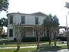
Alger-Sullivan Lumber Company Residential Historic District |
|
000000001989-09-28-0000September 28, 1989
(#89001586) |
Roughly bounded by Pinewood Avenue, Front Street, Jefferson Avenue, Church Street, and Mayo Street
30°58′07″N 87°15′26″W / 30.968611°N 87.257222°W / 30.968611; -87.257222 (Alger-Sullivan Lumber Company Residential Historic District) |
Century |
|
| 2 |
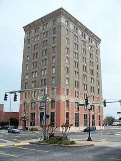
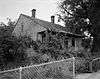
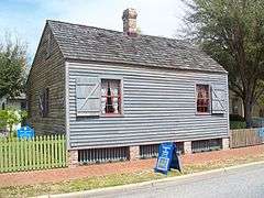
American National Bank Building |
|
000000001978-11-17-0000November 17, 1978
(#78000940) |
226 South Palafox Street
30°24′34″N 87°12′52″W / 30.409444°N 87.214444°W / 30.409444; -87.214444 (American National Bank Building) |
Pensacola |
|
| 3 |
Barrancas National Cemetery |
|
000000001998-02-12-0000February 12, 1998
(#98000083) |
80 Hovey Road
30°21′19″N 87°17′09″W / 30.355278°N 87.285833°W / 30.355278; -87.285833 (Barrancas National Cemetery) |
Pensacola |
Part of the Civil War Era National Cemeteries MPS
|
| 4 |
Crystal Ice Company Building |
|
000000001983-09-29-0000September 29, 1983
(#83001445) |
2024 North Davis Street
30°26′05″N 87°12′46″W / 30.434722°N 87.212778°W / 30.434722; -87.212778 (Crystal Ice Company Building) |
Pensacola |
|
| 5 |
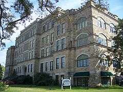
Clara Barkley Dorr House |
|
000000001974-07-24-0000July 24, 1974
(#74000619) |
311 South Adams Street
30°24′32″N 87°12′38″W / 30.408889°N 87.210556°W / 30.408889; -87.210556 (Clara Barkley Dorr House) |
Pensacola |
|
| 6 |
John Edmunds Apartment House |
|
000000001983-09-29-0000September 29, 1983
(#83001444) |
2007 East Gadsden Street
30°25′31″N 87°11′24″W / 30.425278°N 87.19°W / 30.425278; -87.19 (John Edmunds Apartment House) |
Pensacola |
|
| 7 |
Emanuel Point Shipwreck Site |
Upload image |
000000001996-03-04-0000March 4, 1996
(#96000227) |
Address Restricted
|
Pensacola |
|
| 8 |
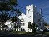
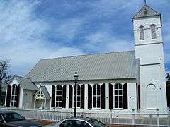
First Christian Church |
|
000000001994-04-14-0000April 14, 1994
(#94000350) |
619 East Gadsden Street, at the junction of 7th Avenue and Gadsden
30°25′17″N 87°12′33″W / 30.421389°N 87.209167°W / 30.421389; -87.209167 (First Christian Church) |
Pensacola |
|
| 9 |
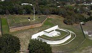
Fort Barrancas Historical District |
|
000000001966-10-15-0000October 15, 1966
(#66000263) |
Naval Air Station Pensacola
30°21′05″N 87°17′53″W / 30.351389°N 87.298056°W / 30.351389; -87.298056 (Fort Barrancas Historical District) |
Pensacola |
|
| 10 |
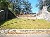
Fort George Site |
|
000000001974-07-08-0000July 8, 1974
(#74000620) |
La Rua at Palafox Street
30°25′07″N 87°13′02″W / 30.418611°N 87.217222°W / 30.418611; -87.217222 (Fort George Site) |
Pensacola |
|
| 11 |
Fort Pickens |
|
000000001972-05-31-0000May 31, 1972
(#72000096) |
State Road 399 west of Pensacola Beach
30°19′20″N 87°16′36″W / 30.322222°N 87.276667°W / 30.322222; -87.276667 (Fort Pickens) |
Pensacola Beach |
|
| 12 |
Hickory Ridge Cemetery Archeological Site |
Upload image |
000000002000-09-22-0000September 22, 2000
(#00001131) |
Address Restricted
|
Pensacola |
|
| 13 |
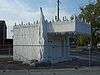
Hyer-Knowles Planing Mill Chimney |
|
000000002012-05-24-0000May 24, 2012
(#12000299) |
Junction of Scenic Bluffs Highway and Langley Ave.
30°28′50″N 87°09′45″W / 30.48064°N 87.16251°W / 30.48064; -87.16251 (Hyer-Knowles Planing Mill Chimney) |
Pensacola |
|
| 14 |
James House |
|
000000002000-12-13-0000December 13, 2000
(#00001501) |
1606 North Martin Luther King Boulevard
30°25′55″N 87°12′49″W / 30.431944°N 87.213611°W / 30.431944; -87.213611 (James House) |
Pensacola |
|
| 15 |
Charles William Jones House |
|
000000001977-12-20-0000December 20, 1977
(#77000403) |
302 North Barcelona Street
30°24′58″N 87°13′12″W / 30.416111°N 87.22°W / 30.416111; -87.22 (Charles William Jones House) |
Pensacola |
|
| 16 |
King-Hooton House |
|
000000001991-08-23-0000August 23, 1991
(#91001090) |
512-514 North 7th Avenue
30°25′13″N 87°12′31″W / 30.420278°N 87.208611°W / 30.420278; -87.208611 (King-Hooton House) |
Pensacola |
|
| 17 |
L & N Marine Terminal Building |
|
000000001972-08-14-0000August 14, 1972
(#72000315) |
Commendencia Street Wharf
30°24′28″N 87°12′41″W / 30.407778°N 87.211389°W / 30.407778; -87.211389 (L & N Marine Terminal Building) |
Pensacola |
|
| 18 |
Lavalle House |
|
000000001971-03-11-0000March 11, 1971
(#71000237) |
203 East Church Street
30°24′32″N 87°12′44″W / 30.408889°N 87.212222°W / 30.408889; -87.212222 (Lavalle House) |
Pensacola |
|
| 19 |
Louisville and Nashville Passenger Station and Express Building |
|
000000001979-06-11-0000June 11, 1979
(#79000670) |
239 North Alcaniz Street
30°25′02″N 87°12′36″W / 30.417222°N 87.21°W / 30.417222; -87.21 (Louisville and Nashville Passenger Station and Express Building) |
Pensacola |
|
| 20 |
Marzoni House |
Upload image |
000000002016-05-10-0000May 10, 2016
(#16000245) |
714 La Rua St.
30°25′13″N 87°12′29″W / 30.420184°N 87.207966°W / 30.420184; -87.207966 (Marzoni House) |
Pensacola |
|
| 21 |
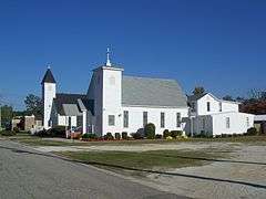
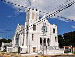
Mount Zion Missionary Baptist Church |
|
000000002013-12-24-0000December 24, 2013
(#13000963) |
528 West Jackson Street
30°25′05″N 87°13′28″W / 30.418124°N 87.224557°W / 30.418124; -87.224557 (Mount Zion Missionary Baptist Church) |
Pensacola |
|
| 22 |
North Hill Preservation District |
|
000000001983-05-09-0000May 9, 1983
(#83001422) |
Roughly bounded by Blount, Palafox, Wright, Belmont, Reus, and DeVilliers Streets
30°25′14″N 87°13′14″W / 30.420556°N 87.220556°W / 30.420556; -87.220556 (North Hill Preservation District) |
Pensacola |
|
| 23 |
Old Christ Church |
|
000000001974-05-03-0000May 3, 1974
(#74000621) |
405 South Adams Street
30°24′33″N 87°12′38″W / 30.409167°N 87.210556°W / 30.409167; -87.210556 (Old Christ Church) |
Pensacola |
|
| 24 |
Palafox Historic District |
|
000000002016-04-27-0000April 27, 2016
(#14001085) |
Palafox St. between Main & Chase extending to Spring
30°24′37″N 87°12′53″W / 30.4104°N 87.2147°W / 30.4104; -87.2147 (Palafox Historic District) |
Pensacola |
|
| 25 |
Pensacola Historic District |
|
000000001970-09-29-0000September 29, 1970
(#70000184) |
Address Unknown
30°24′38″N 87°12′36″W / 30.410556°N 87.21°W / 30.410556; -87.21 (Pensacola Historic District) |
Pensacola |
|
| 26 |
Pensacola Hospital |
|
000000001982-02-16-0000February 16, 1982
(#82002373) |
North 12th Avenue
30°25′34″N 87°12′10″W / 30.426111°N 87.202778°W / 30.426111; -87.202778 (Pensacola Hospital) |
Pensacola |
|
| 27 |
Pensacola Lighthouse and Keeper's Quarters |
|
000000001974-07-15-0000July 15, 1974
(#74000622) |
Naval Air Station Pensacola
30°20′44″N 87°18′29″W / 30.345556°N 87.308056°W / 30.345556; -87.308056 (Pensacola Lighthouse and Keeper's Quarters) |
Pensacola |
|
| 28 |
Pensacola Naval Air Station Historic District |
|
000000001976-12-08-0000December 8, 1976
(#76000595) |
Naval Air Station Pensacola
30°20′47″N 87°16′09″W / 30.346389°N 87.269167°W / 30.346389; -87.269167 (Pensacola Naval Air Station Historic District) |
Pensacola |
|
| 29 |
Perdido Key Historic District |
|
000000001980-03-10-0000March 10, 1980
(#80000404) |
South of Warrington
30°19′32″N 87°19′34″W / 30.325556°N 87.326111°W / 30.325556; -87.326111 (Perdido Key Historic District) |
Warrington |
|
| 30 |
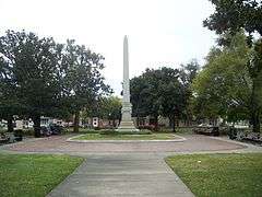
Plaza Ferdinand VII |
|
000000001966-10-15-0000October 15, 1966
(#66000264) |
Palafox Street between Government and Zaragossa Streets
30°24′33″N 87°12′50″W / 30.409167°N 87.213889°W / 30.409167; -87.213889 (Plaza Ferdinand VII) |
Pensacola |
|
| 31 |
Sacred Heart Catholic Church |
|
000000002008-12-10-0000December 10, 2008
(#08001161) |
716 North 9th Avenue
30°25′13″N 87°12′23″W / 30.420278°N 87.206389°W / 30.420278; -87.206389 (Sacred Heart Catholic Church) |
Pensacola |
|
| 32 |
Saenger Theatre |
|
000000001976-07-19-0000July 19, 1976
(#76000596) |
118 South Palafox Street
30°24′37″N 87°12′53″W / 30.410278°N 87.214722°W / 30.410278; -87.214722 (Saenger Theatre) |
Pensacola |
|
| 33 |
St. Joseph's Church Buildings |
|
000000001979-07-10-0000July 10, 1979
(#79000671) |
140 West Government Street
30°24′33″N 87°13′05″W / 30.409167°N 87.218056°W / 30.409167; -87.218056 (St. Joseph's Church Buildings) |
Pensacola |
|
| 34 |
St. Michael's Creole Benevolent Association Hall |
|
000000001974-05-03-0000May 3, 1974
(#74000623) |
416 East Government Street
30°24′37″N 87°12′33″W / 30.410278°N 87.209167°W / 30.410278; -87.209167 (St. Michael's Creole Benevolent Association Hall) |
Pensacola |
|
| 35 |
Thiesen Building |
|
000000001979-12-13-0000December 13, 1979
(#79000672) |
40 South Palafox Street
30°24′32″N 87°12′38″W / 30.408889°N 87.210556°W / 30.408889; -87.210556 (Thiesen Building) |
Pensacola |
|
| 36 |
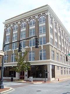
United States Post Office and Court House |
|
000000002014-07-11-0000July 11, 2014
(#14000389) |
100 N. Palafox St.
30°24′52″N 87°12′56″W / 30.414569°N 87.215631°W / 30.414569; -87.215631 (United States Post Office and Court House) |
Pensacola |
|
| 37 |
US Customs House and Post Office |
|
000000001997-07-22-0000July 22, 1997
(#97000659) |
223 Palafox Place
30°24′34″N 87°12′54″W / 30.409444°N 87.215°W / 30.409444; -87.215 (US Customs House and Post Office) |
Pensacola |
|
| 38 |
USS MASSACHUSETTS-BB-2 (shipwreck) |
|
000000002001-05-31-0000May 31, 2001
(#01000528) |
1-mile (1.6 km) south-southwest of Pensacola Pass
Coordinates missing |
Pensacola |
|


.jpg)


%2C_Antonio_Jacobsen.jpg)