National Register of Historic Places listings in Columbia County, Washington
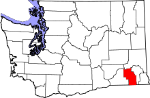
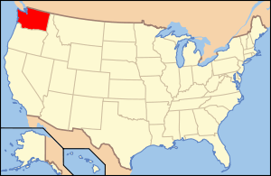
Location of Columbia County in Washington
This is a list of the National Register of Historic Places listings in Columbia County, Washington.
This is intended to be a complete list of the properties and districts on the National Register of Historic Places in Columbia County, Washington, United States. Latitude and longitude coordinates are provided for many National Register properties and districts; these locations may be seen together in a map.[1]
There are 20 properties and districts listed on the National Register in the county.
- This National Park Service list is complete through NPS recent listings posted December 2, 2016.[2]
Current listings
| [3] | Name on the Register[4] | Image | Date listed[5] | Location | City or town | Description |
|---|---|---|---|---|---|---|
| 1 | Bank of Starbuck | 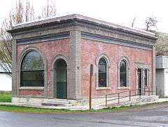 |
(#78002739) |
Main and McNeil Sts. 46°31′11″N 118°07′35″W / 46.519722°N 118.126389°W |
Starbuck | |
| 2 | A. H. Bishop House |  |
(#86001516) |
622 E. Richmond 46°19′33″N 117°58′31″W / 46.325833°N 117.975278°W |
Dayton | |
| 3 | John Brining House | 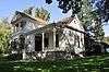 |
(#86001517) |
410 N. First 46°19′23″N 117°58′54″W / 46.323056°N 117.981667°W |
Dayton | |
| 4 | Columbia County Courthouse |  |
(#75001845) |
341 E. Main 46°19′17″N 117°58′40″W / 46.321389°N 117.977778°W |
Dayton | |
| 5 | Dayton Depot |  |
(#74001949) |
2nd and Commercial Sts. 46°19′15″N 117°58′44″W / 46.320833°N 117.978889°W |
Dayton | |
| 6 | Dexter House No. 1 |  |
(#86001519) |
515 S. Fourth 46°19′06″N 117°58′18″W / 46.318333°N 117.971667°W |
Dayton | |
| 7 | Dexter House No. 2 |  |
(#86001520) |
507 N. Third 46°19′28″N 117°58′47″W / 46.324444°N 117.979722°W |
Dayton | |
| 8 | Downtown Dayton Historic District |  |
(#99000567) |
Roughly along Main St., from Front to third Sts. 46°19′15″N 117°58′41″W / 46.320833°N 117.978056°W |
Dayton | |
| 9 | Frank Flintner House |  |
(#86001522) |
214 S. Sixth 46°19′15″N 117°58′18″W / 46.320833°N 117.971667°W |
Dayton | |
| 10 | Guernsey-Sturdevant Building |  |
(#92001589) |
225 E. Main St. 46°19′12″N 117°58′45″W / 46.32°N 117.979167°W |
Dayton | |
| 11 | Grover J. Israel House |  |
(#86001525) |
305 S. Sixth 46°19′16″N 117°58′17″W / 46.321111°N 117.971389°W |
Dayton | |
| 12 | Mancel Kelley House |  |
(#86001526) |
1301 S. Fifth 46°18′37″N 117°57′41″W / 46.310278°N 117.961389°W |
Dayton | |
| 13 | Mill House |  |
(#86001528) |
504 N. First 46°19′25″N 117°58′57″W / 46.323611°N 117.9825°W |
Dayton | |
| 14 | Andrew Nilsson House | 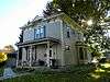 |
(#86001530) |
312 E. Patit 46°19′23″N 117°58′45″W / 46.323056°N 117.979167°W |
Dayton | |
| 15 | Dr. Marcel Pietrzycki House |  |
(#86001531) |
415 E. Clay 46°19′16″N 117°58′31″W / 46.321111°N 117.975278°W |
Dayton | |
| 16 | Snake River Bridge | 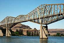 |
(#82004207) |
N of SR 12 46°35′28″N 118°13′28″W / 46.591111°N 118.224444°W |
Lyons Ferry | Historic Bridges and Tunnels in Washington TR |
| 17 | South Side Historic District |  |
(#86001515) |
Roughly bounded by Clay, Third, Park, and First Sts. 46°19′04″N 117°58′33″W / 46.317778°N 117.975833°W |
Dayton | |
| 18 | J. A. Thronson House |  |
(#86001532) |
510 S. Fourth 46°19′05″N 117°58′19″W / 46.318056°N 117.971944°W |
Dayton | |
| 19 | Washington Street Historic District |  |
(#86001514) |
Roughly Washington St. between Patit Creek and Third St. 46°19′19″N 117°58′49″W / 46.321944°N 117.980278°W |
Dayton | |
| 20 | Jacob Weinhard House |  |
(#86001524) |
NW of Dayton 46°19′17″N 117°59′47″W / 46.321389°N 117.996389°W |
Dayton |
See also
| Wikimedia Commons has media related to National Register of Historic Places in Columbia County, Washington. |
References
- ↑ The latitude and longitude information provided in this table was derived originally from the National Register Information System, which has been found to be fairly accurate for about 99% of listings. For about 1% of NRIS original coordinates, experience has shown that one or both coordinates are typos or otherwise extremely far off; some corrections may have been made. A more subtle problem causes many locations to be off by up to 150 yards, depending on location in the country: most NRIS coordinates were derived from tracing out latitude and longitudes off of USGS topographical quadrant maps created under the North American Datum of 1927, which differs from the current, highly accurate WGS84 GPS system used by most on-line maps. Chicago is about right, but NRIS longitudes in Washington are higher by about 4.5 seconds, and are lower by about 2.0 seconds in Maine. Latitudes differ by about 1.0 second in Florida. Some locations in this table may have been corrected to current GPS standards.
- ↑ "National Register of Historic Places: Weekly List Actions". National Park Service, United States Department of the Interior. Retrieved on December 2, 2016.
- ↑ Numbers represent an ordering by significant words. Various colorings, defined here, differentiate National Historic Landmarks and historic districts from other NRHP buildings, structures, sites or objects.
- ↑ National Park Service (2008-04-24). "National Register Information System". National Register of Historic Places. National Park Service.
- ↑ The eight-digit number below each date is the number assigned to each location in the National Register Information System database, which can be viewed by clicking the number.

| Topics | |
|---|---|
| Lists by states |
|
| Lists by insular areas | |
| Lists by associated states | |
| Other areas | |
| |
Municipalities and communities of Columbia County, Washington, United States | ||
|---|---|---|
| City | | |
| Town | ||
| Unicorporated communities | ||
| Ghost towns | ||
This article is issued from Wikipedia - version of the 4/30/2016. The text is available under the Creative Commons Attribution/Share Alike but additional terms may apply for the media files.