Macfarlan, West Virginia
For the surname, see Macfarlan.
| Macfarlan | |
|---|---|
| Unincorporated community | |
 Macfarlan  Macfarlan Location within the state of West Virginia | |
| Coordinates: 39°4′40″N 81°11′55″W / 39.07778°N 81.19861°WCoordinates: 39°4′40″N 81°11′55″W / 39.07778°N 81.19861°W | |
| Country | United States |
| State | West Virginia |
| County | Ritchie |
| Time zone | Eastern (EST) (UTC-5) |
| • Summer (DST) | EDT (UTC-4) |
| ZIP codes | 26148 |
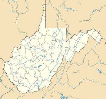
Macfarlan (also MacFarlan) is an unincorporated community in southwestern Ritchie County, West Virginia, United States. It lies along West Virginia Route 47 southwest of the town of Harrisville, the county seat of Ritchie County.[1] Its elevation is 653 feet (199 m).[2] Although it is unincorporated, it has a post office, with the ZIP code of 26148.[3]
The community was named after a pioneer named by Macfarlan whose party was attacked by Indians near the town site.[4]
References
- ↑ Rand McNally. The Road Atlas '08. Chicago: Rand McNally, 2008, p. 112.
- ↑ U.S. Geological Survey Geographic Names Information System: Macfarlan, West Virginia, Geographic Names Information System, 1980-06-27. Accessed 2008-04-23.
- ↑ Zip Code Lookup
- ↑ Kenny, Hamill (1945). West Virginia Place Names: Their Origin and Meaning, Including the Nomenclature of the Streams and Mountains. Piedmont, WV: The Place Name Press. p. 393.
Municipalities and communities of Ritchie County, West Virginia, United States | ||
|---|---|---|
| City | 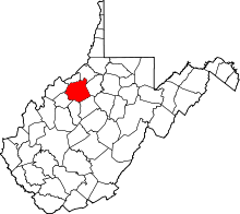 | |
| Towns | ||
| Unincorporated communities |
| |
| Ghost towns | ||
| Footnotes | ‡This populated place also has portions in an adjacent county or counties | |
This article is issued from Wikipedia - version of the 7/28/2016. The text is available under the Creative Commons Attribution/Share Alike but additional terms may apply for the media files.