List of the major 4000-metre summits of Canada

The following sortable table comprises the 19 mountain peaks of Canada with at least 4000 metres (13,123 feet) of elevation and at least 500 metres (1640 feet) of topographic prominence.[1]
The summit of a mountain or hill may be measured in three principal ways:
- The topographic elevation of a summit measures the height of the summit above a geodetic sea level.[2]
- The topographic prominence of a summit is a measure of how high the summit rises above its surroundings.[3][2]
- The topographic isolation (or radius of dominance) of a summit measures how far the summit lies from its nearest point of equal elevation.[4]
Five major Canadian summits exceed 5000 metres (16,404 feet) elevation, 11 exceed 4500 metres (14,764 feet), the following 19 summits exceed 4000 metres (13,123 feet), 41 exceed 3500 metres (11,483 feet), 67 exceed 3000 metres (9843 feet), and 125 exceed 2500 metres (8202 feet) elevation.
Major 4000-metre summits
Of these 19 major 4000-metre summits of Canada, 17 are located in Yukon and two in British Columbia. Five of these summits lie on the international Yukon-Alaska border and one lies on the international British Columbia-Alaska border.
Gallery
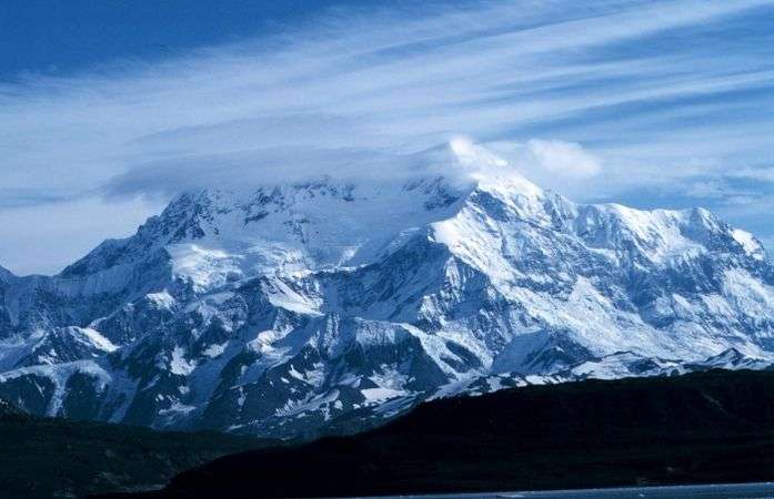
- 1. Mount Logan in Yukon is the highest summit of Canada.
 2. Mount Saint Elias is the second highest summit of both Canada and the United States.
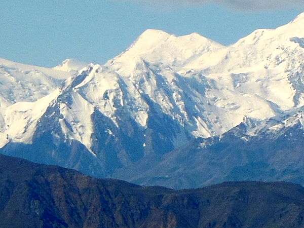 3. Mount Lucania in Yukon is the highest summit of the northern Saint Elias Mountains.
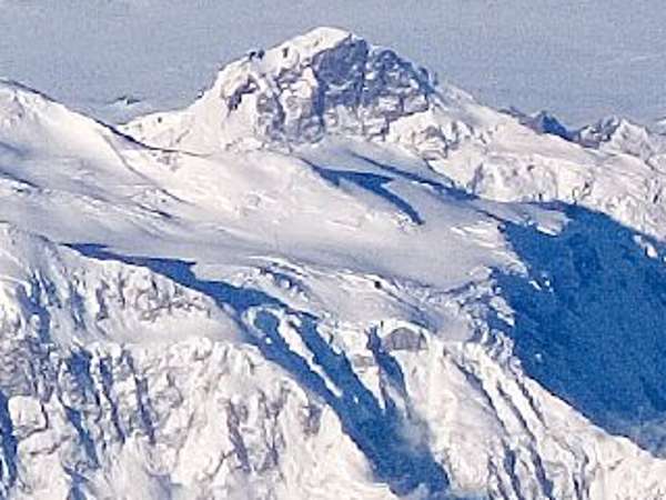 4. King Peak in Yukon is the fourth highest summit of Canada.
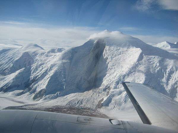 5. Mount Steele in Yukon is the fifth highest summit of Canada.
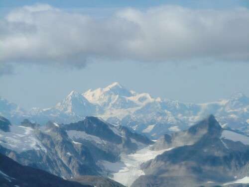 9. Mount Fairweather on the Alaska border is the highest summit of British Columbia.
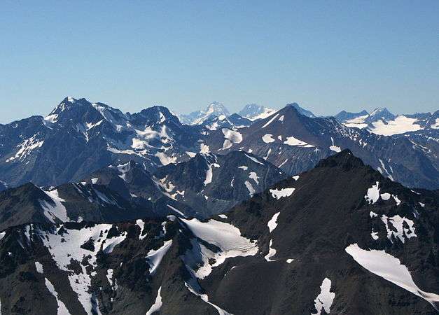 19. Mount Waddington is the highest summit of the Coast Mountains of British Columbia.
See also
- List of mountain peaks of North America
- List of mountain peaks of Greenland
- List of mountain peaks of Canada
- List of mountain peaks of the Rocky Mountains
- List of mountain peaks of the United States
- List of mountain peaks of México
- List of mountain peaks of Central America
- List of mountain peaks of the Caribbean
- Canada
- Geography of Canada
- Category:Mountains of Canada
- Geography of Canada
- Physical geography
References
- ↑ This article defines a significant summit as a summit with at least 100 metres (328.1 feet) of topographic prominence, and a major summit as a summit with at least 500 metres (1640 feet) of topographic prominence. All summits in this article have at least 500 meters of topographic prominence. An ultra-prominent summit is a summit with at least 1500 metres (4921 feet) of topographic prominence.
- 1 2 If the elevation or prominence of a summit is calculated as a range of values, the arithmetic mean is shown.
- ↑ The topographic prominence of a summit is the topographic elevation difference between the summit and its highest or key col to a higher summit. The summit may be near its key col or quite far away. The key col for Denali in Alaska is the Isthmus of Rivas in Nicaragua, 7642 kilometers (4749 miles) away.
- ↑ The topographic isolation of a summit is the great-circle distance to its nearest point of equal elevation.
- ↑ The summit of Mount Logan is the highest point of the Saint Elias Mountains, Yukon, and all of Canada.
- ↑ "Mount Logan". Peakbagger.com. Retrieved 4 May 2016.
- ↑ "Mount Logan". Bivouac.com. Retrieved 4 May 2016.
- ↑ Mount Saint Elias is the second highest major summit of both Canada and the United States.
- ↑ "Mount Saint Elias". Peakbagger.com. Retrieved 4 May 2016.
- ↑ "Mount Saint Elias". Bivouac.com. Retrieved 4 May 2016.
- ↑ The summit of Mount Lucania is the highest point of the northern Saint Elias Mountains.
- ↑ Mount Lucania is the northernmost summit of its elevation in Canada.
- ↑ "Mount Lucania". Peakbagger.com. Retrieved 4 May 2016.
- ↑ "Mount Lucania". Bivouac.com. Retrieved 4 May 2016.
- ↑ "King Peak". Peakbagger.com. Retrieved 4 May 2016.
- ↑ "King Peak". Bivouac.com. Retrieved 4 May 2016.
- ↑ Mount Steele is the northernmost and easternmost 5000-meter (16,404-foot) summit of Canada.
- ↑ "Mount Steele". Peakbagger.com. Retrieved 4 May 2016.
- ↑ "Mount Steele". Bivouac.com. Retrieved 4 May 2016.
- ↑ Mount Wood is the northernmost summit of its elevation in Canada.
- ↑ "Mount Wood". Peakbagger.com. Retrieved 4 May 2016.
- ↑ "Mount Wood". Bivouac.com. Retrieved 4 May 2016.
- ↑ Mount Vancouver is the easternmost summit of its elevation in Canada.
- ↑ "Mount Vancouver". Peakbagger.com. Retrieved 4 May 2016.
- ↑ "Mount Vancouver". Bivouac.com. Retrieved 4 May 2016.
- ↑ "Mount Slaggard". Peakbagger.com. Retrieved 4 May 2016.
- ↑ "Mount Slaggard". Bivouac.com. Retrieved 4 May 2016.
- ↑ Mount Fairweather lies on the international border between Alaska and British Columbia. The peak is the highest point of the Canadian Province of British Columbia and the southernmost and easternmost summit of its elevation in both Canada and the United States.
- ↑ "Mount Fairweather". Peakbagger.com. Retrieved 4 May 2016.
- ↑ "Mount Fairweather". Bivouac.com. Retrieved 4 May 2016.
- ↑ "Mount Hubbard". Peakbagger.com. Retrieved 4 May 2016.
- ↑ "Mount Hubbard". Bivouac.com. Retrieved 4 May 2016.
- ↑ "Mount Walsh". Peakbagger.com. Retrieved 4 May 2016.
- ↑ "Mount Walsh". Bivouac.com. Retrieved 4 May 2016.
- ↑ "BOUNDARY POINT 180". Datasheet for NGS Station UV3032. United States National Geodetic Survey. Retrieved 4 May 2016.
- ↑ "Mount Alverstone". Peakbagger.com. Retrieved 4 May 2016.
- ↑ "Mount Alverstone". Bivouac.com. Retrieved 4 May 2016.
- ↑ "McArthur Peak". Peakbagger.com. Retrieved 4 May 2016.
- ↑ "McArthur Peak". Bivouac.com. Retrieved 4 May 2016.
- ↑ "Mount Augusta". Peakbagger.com. Retrieved 4 May 2016.
- ↑ "Mount Augusta". Bivouac.com. Retrieved 4 May 2016.
- ↑ Mount Strickland is the northernmost summit of its elevation in Canada.
- ↑ "Mount Strickland". Peakbagger.com. Retrieved 4 May 2016.
- ↑ "Mount Strickland". Bivouac.com. Retrieved 4 May 2016.
- ↑ Avalanche Peak is the northernmost summit of its elevation in Canada.
- ↑ "Avalanche Peak". Peakbagger.com. Retrieved 4 May 2016.
- ↑ "Avalanche Peak". Bivouac.com. Retrieved 4 May 2016.
- ↑ "Mount Cook". Peakbagger.com. Retrieved 4 May 2016.
- ↑ "Mount Cook". Bivouac.com. Retrieved 4 May 2016.
- ↑ Mount Craig is the northernmost 4000-meter (13,123-foot) summit of Canada.
- ↑ "Mount Craig". Peakbagger.com. Retrieved 4 May 2016.
- ↑ "Mount Craig". Bivouac.com. Retrieved 4 May 2016.
- ↑ The summit of Mount Waddington is the highest point of the Coast Mountains.
- ↑ Mount Waddington is the southernmost and easternmost 4000-meter (13,123-foot) summit of Canada.
- ↑ "Mount Waddington". Peakbagger.com. Retrieved 4 May 2016.
- ↑ "Mount Waddington". Bivouac.com. Retrieved 4 May 2016.
External links
| History |
| ||||||
|---|---|---|---|---|---|---|---|
| Provinces and territories |
| ||||||
| Government | |||||||
| Politics | |||||||
| Geography |
| ||||||
| Economy | |||||||
| Society | |||||||
| Demographics |
| ||||||
| Culture | |||||||
| Symbols | |||||||
| Article overviews | |||||||
| Research | |||||||
| |||||||
Coordinates: 60°34′02″N 140°24′20″W / 60.5671°N 140.4055°W