List of Category A listed buildings in Stirling

This is a list of Category A listed buildings in the Stirling council area in central Scotland.
In Scotland, the term listed building refers to a building or other structure officially designated as being of "special architectural or historic interest".[1] Category A structures are those considered to be "buildings of national or international importance, either architectural or historic, or fine little-altered examples of some particular period, style or building type."[2] Listing was begun by a provision in the Town and Country Planning (Scotland) Act 1947, and the current legislative basis for listing is the Planning (Listed Buildings and Conservation Areas) (Scotland) Act 1997.[3] The authority for listing rests with Historic Scotland, an executive agency of the Scottish Government, which inherited this role from the Scottish Development Department in 1991. Once listed, severe restrictions are imposed on the modifications allowed to a building's structure or its fittings. Listed building consent must be obtained from local authorities prior to any alteration to such a structure.[3] There are approximately 47,400 listed buildings in Scotland, of which around 8% (some 3,800) are Category A.[4]
The council area of Stirling covers 2,187 square kilometres (844 sq mi), and has a population of around 88,400. There are 84 Category A listed buildings in the area.
Listed buildings


See also
Category:Listed buildings in Stirling (council area)
Notes
- ↑ Sometimes known as OSGB36, the grid reference (where provided) is based on the British national grid reference system used by the Ordnance Survey.
• "Guide to National Grid". Ordnance Survey. Retrieved 2007-12-12.
• "Get-a-map". Ordnance Survey. Retrieved 2007-12-17. - ↑ The "HB Number" is a unique number assigned to each listed building by Historic Scotland.
References
- ↑ Guide to the Protection of Scotland’s Listed Buildings (PDF). Historic Scotland. 2009. p. 4. ISBN 978-1-84917-013-0. Retrieved 2010-05-05.
- ↑ "What is Listing?". Historic Scotland. Retrieved 2010-05-05.
- 1 2 Scottish Historic Environment Policy (PDF). Historic Scotland. October 2008. pp. 24–25. ISBN 978-1-84917-002-4. Retrieved 2010-05-05.
- ↑ Guide to the Protection of Scotland’s Listed Buildings, p. 17.
- ↑ "Lecropt Church: Listed Building Report". Historic Scotland.
- ↑ "Keir, Keir Home Farm: Listed Building Report". Historic Scotland.
- ↑ "Keir, South Lodge: Listed Building Report". Historic Scotland.
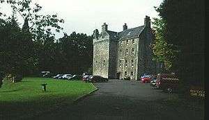
- ↑ "Keir House: Listed Building Report". Historic Scotland.
- ↑ "Auchentroig, Old Auchentroig: Listed Building Report". Historic Scotland.
- ↑ "Queen Victoria School, Dunblane: Listed Building Report". Historic Scotland.
- ↑ "Memorial Chapel, Dunblane: Listed Building Report". Historic Scotland.
- ↑ "Cromlix House, Sundial and Flanking Pair of Gatepiers: Listed Building Report". Historic Scotland.
- ↑ "Loch Venachar Dam/Sluice House Including Weir And Water Conduit (Formerly Glasgow Corporation Water Works): Listed Building Report". Historic Scotland.
- ↑ "Edinample Castle With Ancillary Building, Bothy And Garden Walls: Listed Building Report". Historic Scotland.
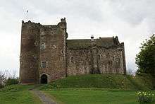
- ↑ "Doune Castle: Listed Building Report". Historic Scotland.
- ↑ "Drip Old Bridge Over River Forth: Listed Building Report". Historic Scotland.
- ↑ "Catter House: Listed Building Report". Historic Scotland.
- ↑ "Gribloch House And Swimming Pool: Listed Building Report". Historic Scotland.
- ↑ "Doune Stable Block: Listed Building Report". Historic Scotland.
- ↑ "Old Newton House, Doune: Listed Building Report". Historic Scotland.
- ↑ "Deanston Mill, Old Spinning Mill: Listed Building Report". Historic Scotland.
- ↑ "Deanston Mill, Old Weaving Shed: Listed Building Report". Historic Scotland.
- ↑ "Lanrick Macgregor Monument: Listed Building Report". Historic Scotland.
- ↑ "Killin, Bridge Of Dochart Over Falls Of Dochart: Listed Building Report". Historic Scotland.
- ↑ "Killin, Railway Viaduct Over River Dochart: Listed Building Report". Historic Scotland.
- ↑ "Parish Church, Kincardine: Listed Building Report". Historic Scotland.
- ↑ "Buchanan Monument: Listed Building Report". Historic Scotland.
- ↑ "Killearn, Auchenibert With Terraced Garden: Listed Building Report". Historic Scotland.
- ↑ "Gargunnock House: Listed Building Report". Historic Scotland.
- ↑ "Old Leckie House: Listed Building Report". Historic Scotland.
- ↑ "Blairlogie Castle: Listed Building Report". Historic Scotland.
- ↑ "Culcreuch Castle: Listed Building Report". Historic Scotland.
- ↑ "Kippen, Station Road, Dun Eaglais, Including Designed Garden: Listed Building Report". Historic Scotland.
- ↑ "Milnholm Hatchery: Listed Building Report". Historic Scotland.
- ↑ "Bannockburn House: Listed Building Report". Historic Scotland.
- ↑ "Touch House (Mrs Buchanan): Listed Building Report". Historic Scotland.
- ↑ "Auchenbowie House: Listed Building Report". Historic Scotland.
- ↑ "Howietoun Fishery: Listed Building Report". Historic Scotland.
- ↑ "Mugdock Castle And Chapel: Listed Building Report". Historic Scotland.
- ↑ "Cambusbarron, Hayford Mills: Listed Building Report". Historic Scotland.
- ↑ "Cardross House: Listed Building Report". Historic Scotland.
- ↑ "Bridge Of Ardoch (Old): Listed Building Report". Historic Scotland.
- ↑ "Bridge Of Teith: Listed Building Report". Historic Scotland.
- ↑ "Market Cross The Cross: Listed Building Report". Historic Scotland.
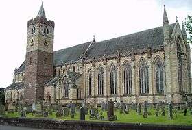
- ↑ "Cathedral Square, Dunblane Cathedral (Cathedral Church Of St Blaan And St Laurence Including Churchyard, Boundary Wall And Riccarton's Stile): Listed Building Report". Historic Scotland.
- ↑ "Leewood Road, Ault Wharrie Including Summer House, Walled Garden, Terraced Garden Wall, Gate Lodge, Boundary Wall And Gatepiers: Listed Building Report". Historic Scotland.
- ↑ "The Cross, Leighton Library: Listed Building Report". Historic Scotland.
- ↑ "The Cross, Cathedral Museum, Including Residential Properties To South Adjoining Burgh Chambers And Well To Rear: Listed Building Report". Historic Scotland.
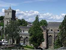
- ↑ "Church Of The Holy Rood St John Street: Listed Building Report". Historic Scotland.
- ↑ "Church Of The Holy-Rood Churchyard: Listed Building Report". Historic Scotland.
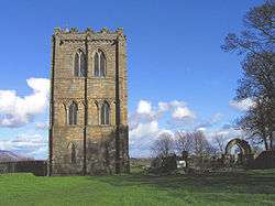
- ↑ "Cambuskenneth Abbey: Listed Building Report". Historic Scotland.
- ↑ "Holy Trinity Episcopal Church 26 Dumbarton Road: Listed Building Report". Historic Scotland.
- ↑ "St Ninians Old Parish Kirk Kirk Wynd: Listed Building Report". Historic Scotland.
- ↑ "St. Ninians Old Parish Kirk Kirkyard: Listed Building Report". Historic Scotland.
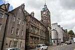
- ↑ "2 Spittal Street And 65, 67 King Street, Athenaeum: Listed Building Report". Historic Scotland.
- ↑ "Cowane's Hospital (Now Guildhall) Including Adjoining Terrace To Bowling Green 47, 49 St John Street And Lampstands: Listed Building Report". Historic Scotland.
- ↑ "31 St John Street, Stirling Old Town Jail (Former Military Prison) With Boundary Walls, Gatepiers And Gates: Listed Building Report". Historic Scotland.
- ↑ "35, 37 Broad Street, Jail Wynd And 32 St John Street, Tolbooth: Listed Building Report". Historic Scotland.
- ↑ "Back Walk, Town Wall, South Boundary Of Erskine Marykirk And St John Street Housing Development To Academy Street: Listed Building Report". Historic Scotland.
- ↑ "Back Walk, Town Wall And Bastion, Boundary Of Municipal Buildings, 27-33 (Odd Nos) Spittal Street And Old High School: Listed Building Report". Historic Scotland.
- ↑ "Town Wall Public Library To 16 Dumbarton Road Being S Boundary Of 16 Dumbarton Road, 2, 4 Back Walk, 51 King Street 15 And 19 Corn Exchange Road: Listed Building Report". Historic Scotland.
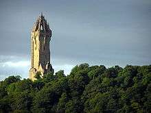
- ↑ "Wallace Monument Abbey Craig: Listed Building Report". Historic Scotland.
- ↑ "The Old Town Cemeteries: Listed Building Report". Historic Scotland.
- ↑ "Stirling, Old Bridge: Listed Building Report". Historic Scotland.
- ↑ "Stirling Railway Station, Station Road, With North And Middle Signal Boxes And Associated Semaphore Signals: Listed Building Report". Historic Scotland.
- ↑ "Academy Road, Stirling Highland Hotel, Old High School: Listed Building Report". Historic Scotland.
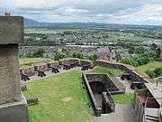
- ↑ "Stirling Castle (Comprising): Outer Defences The Counter Guard (1708–14): Listed Building Report". Historic Scotland.
- ↑ "Stirling Castle Forework (1500–1510): Listed Building Report". Historic Scotland.
- ↑ "Stirling Castle Palace (1539–42): Listed Building Report". Historic Scotland.
- ↑ "Stirling Castle Great Hall (1503): Listed Building Report". Historic Scotland.
- ↑ "Stirling Castle Chapel Royal (1594): Listed Building Report". Historic Scotland.
- ↑ "Stirling Castle The Mint (14th-century): Listed Building Report". Historic Scotland.
- ↑ "Stirling Castle Kitchen Range And Grand Battery: Listed Building Report". Historic Scotland.
- ↑ "Stirling Castle The King's Old Building: Listed Building Report". Historic Scotland.
- ↑ "Stirling Castle Sundial: Listed Building Report". Historic Scotland.
- ↑ "Stirling Castle Regimental Headquarters: Listed Building Report". Historic Scotland.
- ↑ "16 (Part) And 18 Bow Street, Erskine Of Gogar's House (Commonly Known As Darnley's House): Listed Building Report". Historic Scotland.
- ↑ "16 Bow Street (Part, Within Close), Moir Of Leckie's House: Listed Building Report". Historic Scotland.
- ↑ "16 Broad Street, East Section Of James Norrie's Lodging: Listed Building Report". Historic Scotland.
- ↑ "Castle Wynd Argyll Lodging (Including Garden Wall.) Now Youth Hostel.: Listed Building Report". Historic Scotland.
- ↑ "Mar Place Mar's Wark: Listed Building Report". Historic Scotland.
- ↑ "39 And 41 St John Street, Bruce Of Auchenbowie's House: Listed Building Report". Historic Scotland.
- ↑ "St Mary's Wynd John Cowane's House: Listed Building Report". Historic Scotland.
- ↑ "56 Spittal Street, Glengarry Lodge Or Darrow Lodging: Listed Building Report". Historic Scotland.
- ↑ "Deanston Mills, Weir: Listed Building Report". Historic Scotland.
- ↑ "Bannockburn, Rotunda, Memorial Cairn, Flagpole And Statue Of King Robert I: Listed Building Report". Historic Scotland.
- ↑ "Gartmore, Cayzer Family Private Cemetery, Sundial: Listed Building Report". Historic Scotland.
External links
![]() Media related to Category A listed buildings in Stirling council area at Wikimedia Commons
Media related to Category A listed buildings in Stirling council area at Wikimedia Commons