Källunge
| Källunge | |
|---|---|
|
Källunge Church | |
 Källunge | |
| Coordinates: 57°36′28″N 18°35′4″E / 57.60778°N 18.58444°ECoordinates: 57°36′28″N 18°35′4″E / 57.60778°N 18.58444°E | |
| Country | Sweden |
| Province | Gotland |
| County | Gotland County |
| Municipality | Gotland Municipality |
| Area[1] | |
| • Total | 18 km2 (7 sq mi) |
| Population (2014)[2] | |
| • Total | 196 |
| Time zone | CET (UTC+1) |
| • Summer (DST) | CEST (UTC+2) |
Källunge is a settlement on the Swedish island of Gotland. Formerly a socken,[3] on 1 January 2016, it was reconstituted into the administrative area Källunge District.[4]
Geography
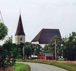
Källunge is situated in the central northern part of Gotland.[5] The medieval Källunge Church is located in the socken.[6]
One of the asteroids in the asteroid belt, 10545 Källunge, is named after this place.[7]
References
- ↑ Carlquist, Gunnar, ed. (1947–1955). "Källunge socken". Svensk Uppslagsbok (in Swedish) (2nd ed.). Malmö: Förlagshuset Norden.
- ↑ "Gotland i siffror 2015" [Gotland in numbers 2015]. www.gotland.se. Gotland Municipality. Retrieved 2 June 2016.
- ↑ The exact extent of the socken, now district, can be obtained by clicking on Kartinställningar and check the Socken box in the menu of this map from the Swedish National Heritage Board database.
- ↑ "Förordning om district" [Regulation of districts] (PDF). Ministry of Finance. 17 June 2015. Retrieved 1 June 2016.
- ↑ "Källunge". www.ne.se. Nationalencyklopedin. Retrieved 1 June 2016.
- ↑ Enderborg, Bernt. "Källunge kyrka". www.guteinfo.com. Guteinfo. Retrieved 2 June 2016.
- ↑ "10545 Kallunge (1992 EQ9)". NASA. Retrieved 1 June 2016.
External links
| Wikimedia Commons has media related to Källunge. |
This article is issued from Wikipedia - version of the 11/23/2016. The text is available under the Creative Commons Attribution/Share Alike but additional terms may apply for the media files.