Dearfield, Colorado
|
Dearfield | |
|
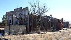
Building in Dearfield | |
  | |
| Location | Weld County, Colorado |
|---|---|
| Nearest city | Wiggins, Colorado |
| Coordinates | 40°17′18″N 104°15′25″W / 40.28833°N 104.25694°WCoordinates: 40°17′18″N 104°15′25″W / 40.28833°N 104.25694°W |
| Area | 160 acres (65 ha) |
| Built | 1910 |
| Architectural style | False front |
| NRHP Reference # | 95001002[1] |
| Added to NRHP | August 4, 1995 |
Dearfield is a ghost town and a historically black majority settlement in Weld County, Colorado, United States. It is 30 miles (48 km) east of Greeley. The town was formed by Oliver T. Jackson who desired to create a colony for African Americans. In 1910, Jackson, a successful businessman from Boulder, filed on the homestead that later became the town and began to advertise for "colonists." The name Dearfield was suggested by one of the town's citizens, Dr. J.H.P. Westbrook who was from Denver. The word dear was chosen as the foundation for the town's name due to the precious value of the land and community to the town's settlers.[2]
The first settlers of Dearfield had great difficulty farming the surrounding pasture and endured several harsh seasons. However, by 1921, 700 people lived in Dearfield. The town's net worth was appraised at $1,075,000. After several prosperous years, the Great Depression arrived and the town's agricultural success significantly declined. Settlers began to leave Dearfield in order to find better opportunities. By 1940, the town population had decreased to 12, only 2% of the town's 1921 population. Jackson desperately attempted to spur interest in the town, even offering it for sale. However, there was little interest in Dearfield. Jackson died on February 18, 1948.
A few deserted buildings remain in Dearfield: a gas station, a diner, and the founder's home. In 1998, Black American West Museum in Denver began to make attempts to preserve the town's site. It is a Colorado Registered Historic Landmark. A 2010 monument next to one of the remaining buildings contains information about the history of the site.
A 2001 state historical marker [3] at U.S. Route 85 mile marker 264 near Evans, Colorado, includes a panel with the history of Dearfield.


See also
- National Register of Historic Places listings in Weld County, Colorado
- Allensworth, California
- Boley, Oklahoma
- Nicodemus, Kansas
References
- ↑ National Park Service (2009-03-13). "National Register Information System". National Register of Historic Places. National Park Service.
- ↑ Dawson, John Frank. Place names in Colorado: why 700 communities were so named, 150 of Spanish or Indian origin. Denver, CO: The J. Frank Dawson Publishing Co. p. 17.
- ↑ CHS ID 263 - http://www.coloradohistory.org/RIPsigns/show_markertext.asp?id=864
External links
- University of Northern Colorado Libraries: Dearfield
- Dearfield Colony listing in Colorado Preservation's Endangered Places Program
- Dearfield African-American Farming Colony page at Colorado State University's Architectural Preservation Institute
Municipalities and communities of Weld County, Colorado, United States | ||
|---|---|---|
| Cities |  | |
| Towns | ||
| CDP | ||
| Unincorporated communities | ||
| Ghost towns | ||
| Footnotes | ‡This populated place also has portions in an adjacent county or counties | |
| Topics | |
|---|---|
| Lists by states |
|
| Lists by insular areas | |
| Lists by associated states | |
| Other areas | |
| |