Bristol Bridge
| Bristol Bridge | |
|---|---|
.jpg) Bristol Bridge from Welsh Back | |
| Carries | Motor vehicles, Pedestrians |
| Crosses | Bristol Harbour/River Avon |
| Locale | Bristol |
| Maintained by | Bristol City Council |
| History | |
| Opened | 1768 |
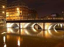
Bristol Bridge is an old bridge over the floating harbour in Bristol, England, the original course of the River Avon. The bridge is now a grade II listed building.[1]
History
Bristol's name is derived from the Saxon Brycgstow or 'Brigstowe', meaning the 'place of the bridge'. However, it is unclear when the first bridge over the Avon was built. The Avon has a high tidal range, so the river could have been forded twice a day. The name may therefore refer to the many smaller bridges over the lesser known River Frome, in the marshy surrounding area, which is now largely built over. The first stone bridge was built in the 13th century, and houses with shopfronts were built on it to pay for its maintenance. A chapel with gate crossed the roadway in the centre. [Adam's Chronicles of Bristol]
A seventeenth century illustration shows that these bridge houses were five stories high, including the attic rooms, and that they overhung the river much as Tudor houses would overhang the street.[2] At the time of the Civil War the bridge was noted for its community of goldsmiths. Houses on the bridge were attractive and charged high rents as they had so much passing traffic, and had plenty of fresh air and waste could be dropped into the river.[2] Its population was also perceived to be strongly parliamentarian.[2]
In the 1760 a bill to replace the bridge was carried through parliament by the Bristol MP Sir Jarrit Smyth.[3] By the early 18th century, increase in traffic and the encroachment of shops on the roadway made the bridge fatally dangerous for many pedestrians, but despite a campaign by Felix Farley in his Journal, no action was taken until a shopkeeper on the bridge employed James Bridges to provide designs. The commission accepted the design of James Bridges after many long drawn out disputes which are still unclear. Bridges fled to the West Indies in 1763 leaving Thomas Paty to complete it between 1763 and 1768. Resentment at the tolls exacted to cross the new bridge occasioned the Bristol Bridge Riot of 1793. The toll houses were turned into shops before they were removed. In the 19th century, the roadway was again congested, so walkways were added on either side, the supporting columns disguising the classical Georgian design. The current metal railings date from the 1960s.
Before the Second World War, Bristol Bridge was an important transport hub. It was the terminus of tram routes to Knowle, Bedminster and Ashton Gate, and other trams also stopped here.[4] It lost importance when Temple Way was built further upstream in the 1930s,[5] and when the tram system closed in 1941.
- Prince's Wharf, including M Shed, Pyronaut and Mayflower adjoining Prince Street Bridge
- Dry docks: SS Great Britain, the Matthew
- St Augustine's Reach, Pero's Bridge
- Bathurst Basin
- Queen Square
- Bristol Temple Meads railway station
- Castle Park
- Redcliffe Quay and Redcliffe Caves
- Baltic Wharf marina
- Cumberland Basin & Brunel Locks
- The New Cut
- Netham Lock, entrance to the Feeder Canal
- Totterdown Basin
- Temple Quay
- The Centre
- Canons Marsh, including Millennium Square and At-Bristol
- Underfall Yard
- Bristol Bridge
See also
-
 Bridges portal
 -
 Bristol portal
References
Notes
- ↑ "Bristol Bridge". Images of England. Retrieved 2006-12-22.
- 1 2 3 Lynch, John (1999) For King & Parliament, ISBN 0-7509-2021-1, p. 10
- ↑ Bantock, Anton (2004) Ashton Court, ISBN 0-7524-3213-3, p. 29
- ↑ "BT&CC tram map, 1911". Bristol Vintage Bus Group. Retrieved 2011-03-04.
- ↑ Sabre roads website: A4044
Reference books
- Barb Drummond 'Death and the Bridge: The Georgian Rebuilding of Bristol Bridge' ISBN 978-0-9551010-5-2
- Barb Drummond 'The Big World of Mr Bridges' Microcosm' ebook on Kindle ISBN 978-0-9562900-8-3 This includes up to date information on the work of the Bristolian architect James Bridges
External links
| Wikimedia Commons has media related to Bristol Bridge. |
Coordinates: 51°27′13″N 2°35′29″W / 51.4536°N 2.5913°W