Bhotewodar
| Bhotewodar भोटेओडार | |
|---|---|
| Village development committee / City | |
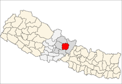
 Bhotewodar Location in Nepal | |
| Coordinates: 28°13′52″N 84°22′39″E / 28.23111°N 84.37750°ECoordinates: 28°13′52″N 84°22′39″E / 28.23111°N 84.37750°E | |
| Country |
|
| Zone | Gandaki Zone |
| District | Lamjung District |
| Elevation | 760 m (2,490 ft) |
| Population (2001) | |
| • Total | 5,897 |
| Time zone | Nepal Time (UTC+5:45) |
| Postal code | 33600 |
| Area code(s) | 066 |
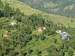
Bhotewodar is one of the main cities of Lamjung District.[1] It is identified as the gateway of East Lamjung. It lies in the Gandaki zone, Nepal.It was named as Bhotewodar
because there was a cave (odhar) in this place where Bhotais used to take shelter during the winter time and used to sell their goods.
So,it was named as Bhotewodar later. It has three government schools and three private boarding schools. Bhakti Namuna Higher Secondary
School was established in 2024 B.S. Students can get education up to diploma level herein. It has got all kind of facilities like
electricity, transportation, communication, health and so on. The climate is very fine to settle. It lies near the Marsyangdi river. It
has Middle Marsyangdi Hydropower House. Newars are the first inhabitants of this place. Later on people from gurung community,
Brahmin community chhetri community also have settled here.
At the time of the 2001 Nepal census it had a population of 5897.[2]
See also
References
- ↑ Lamjung District
- ↑ "Nepal Census 2001", Nepal's Village Development Committees, Digital Himalaya, archived from the original on 12 October 2008, retrieved 9 January 2012.