Pyarjung
| Pyarjung प्यारजंग | |
|---|---|
| Village development committee | |
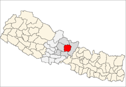
 Pyarjung Location in Nepal | |
| Coordinates: 28°09′N 84°32′E / 28.15°N 84.53°ECoordinates: 28°09′N 84°32′E / 28.15°N 84.53°E | |
| Country |
|
| Zone | Gandaki Zone |
| District | Lamjung District |
| Population (1991) | |
| • Total | 2,256 |
| Time zone | Nepal Time (UTC+5:45) |
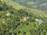
Pyarjung is a village development committee in Lamjung District in the Gandaki Zone of northern-central Nepal. At the time of the 1991 Nepal census it had a population of 2256 people living in 443 individual households.[1]
2015 Nepal earthquake
The village was affected by the earthquake on 25 April 2015. It along with Bichaur, Ilampokhari, Dudhpokhari, Gaudu, and Kolki were the most affected villages in Lamjung district.[2]
References
- ↑ "Nepal Census 2001", Nepal's Village Development Committees, Digital Himalaya, retrieved 15 November 2009.
- ↑ Khan, Hamza (1 May 2015). "Nepal Earthquake: Death toll crosses 5,000, but only 4 die at epicentre". The Indian Express. The Indian Express. Archived from the original on 1 May 2015. Retrieved 1 May 2015.
External links
This article is issued from Wikipedia - version of the 9/11/2016. The text is available under the Creative Commons Attribution/Share Alike but additional terms may apply for the media files.