Atílio Vivacqua
| Atílio Vivacqua | |
|---|---|
| Municipality | |
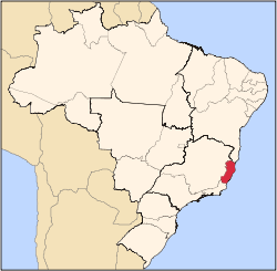
 Atílio Vivacqua Location in Brazil | |
| Coordinates: 20°54′50″S 41°11′52″W / 20.91389°S 41.19778°WCoordinates: 20°54′50″S 41°11′52″W / 20.91389°S 41.19778°W | |
| Country |
|
| Region | Southeast Region |
| State | Espírito Santo |
| Area | |
| • Total | 223 km2 (86 sq mi) |
| Population (2015) | |
| • Total | 11,181 |
| • Density | 50/km2 (130/sq mi) |
| Time zone | BRT/BRST (UTC-3/-2) |
Atílio Vivacqua[lower-alpha 1] is a Brazilian municipality in the state of Espírito Santo. Its population was 11,181 (2015) and its area is 223 km².[1]
The municipality contains part of the 10,459 hectares (25,840 acres) Serra das Torres Natural Monument, created in 2010 to protect the mountain peaks in the area.[2]
History
Until 10 April 1964, Atílio Vivacqua was a district of Cachoeiro de Itapemirim called Marapé.[3] The municipality is named for Senator Atílio Vivácqua (1894–1961).[4]
Notes
- ↑ Due to orthographic changes and Portuguese naming conventions, the first 'a' in Vivacqua sometimes has an acute accent (´).
References
- ↑ IBGE -
- ↑ Hartung Gomes, Paulo Cesar (11 June 2010), Lei Nº 9.463 (in Portuguese), retrieved 2016-10-27
- ↑ "IBGE | Cidades | Espírito Santo | Atilio Vivacqua | Histórico". cidades.ibge.gov.br. Retrieved 2016-05-11.
- ↑ "História". Município de Atílio Vivacqua (in Portuguese). Retrieved 11 May 2016.
Capital: Vitória | ||||||||||||||||
| Mesoregion Central |
|  | ||||||||||||||
| Mesoregion Litoral Norte |
| |||||||||||||||
| Mesoregion Noroeste |
| |||||||||||||||
| Mesoregion Sul |
| |||||||||||||||
This article is issued from Wikipedia - version of the 10/27/2016. The text is available under the Creative Commons Attribution/Share Alike but additional terms may apply for the media files.