Aroya, Colorado
Coordinates: 38°51′15″N 103°07′32″W / 38.8542°N 103.1255°W
| Aroya, Colorado (Arroyo) | |
|---|---|
| Unincorporated community | |
 | |
| Coordinates: 38°51′15″N 103°07′32″W / 38.85417°N 103.12556°W | |
| Country |
|
| State |
|
| Counties | Cheyenne[1] |
| Elevation[1] | 4,580 ft (1,396 m) |
| Time zone | MST (UTC-7) |
| • Summer (DST) | MDT (UTC-6) |
| ZIP code | 80862 (Wild Horse)[2] |
| Area code(s) | 719 |
| GNIS feature ID | 195190 |
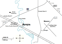
Aroya is a small, rural, unincorporated community in Cheyenne County, Colorado, United States at the eastern end of State Highway 94 near its junction with U.S. Highway 40/U.S. Highway 287.[3] The name Arroyo appears on some older maps.[1] The town was named "Aroya" because of a gulch nearby[4] (arroyo is a Spanish word for "gulch"). The gulch is now named the Aroya Gulch.[5] Aroya originated in 1870 three miles west of the present site as a camp for Kansas-Pacific Railroad track-layers, but was moved to the present site because there was a better supply of water.
The Post Office at Wild Horse (ZIP Code 80862) serves Aroya postal addresses.[2] Aroya has an airfield (Maurer, altitude 4616 ft, inactive), a railroad (Union Pacific Railroad), and a cemetery (Aroya Cemetery[6][7]) within a one-mile radius.[8] Aroya also has an old one-room schoolhouse that was in use until the early 1960s.[9]
The JOD Ranch nearby (named for Joseph Ottmar Dostal, initials J. O. D.) was founded in 1883,[10] and there have been ranching activities in the area since the 1870s.[11] When Cheyenne County was formed in 1889, Joseph Dostal was the new county's largest property taxpayer.[4] The airplane landing strips nearby were a private airfield on JOD Ranch property. The airfield was named after Bill Maurer,[12] one of a number of subsequent owners of the JOD Ranch after it was founded by Joseph Dostal. The landing strips are barely visible because they were dirt and grass landing strips, and they were plowed under in the early 1980s in the process of an unsuccessful attempt to grow wheat after Bill Maurer sold the ranch. The building that was used for the hangar and the pole that was used for the windsock are still in existence.
Carl "Bev" Bledsoe, Colorado's longest serving Speaker of the State House of Representatives, was born in Aroya in 1923.
References
- 1 2 3 "Search for: Aroya, State: Colorado". Geographic Names Information System (GNIS). USGS. 1 Jan 1964.
- 1 2 "Aroya, CO". ZIP Code Lookup. United States Postal Service. Retrieved 2010-12-02.
- ↑ "Aroya". PlaceNames.com. Retrieved 2010-12-02.
- 1 2 "Aroyo, CO - Colorado Historical Markers". Waymarking.com. Retrieved 2011-01-28.
- ↑ "Aroya Gulch". Geographic Names Information System (GNIS). USGS. 13 Oct 1978.
- ↑ "Aroya Cemetery". Find A Grave. Retrieved 2010-12-04.
- ↑ "Aroya Cemetery". Geographic Names Information System (GNIS). USGS. 31 Aug 1992.
- ↑ "Aroya - Cheyenne County, CO.". Topographic Maps. Trails.com. Retrieved 2010-12-02.
- ↑ "Old Aroya School". Panoramio. September 6, 2010.
- ↑ Sign at an entrance to the J.O.D. Ranch located at State Highway 94 and County Road 2. 2011-02-12.
- ↑ Terry K. Blevins (April 1986). "JOD Brand Keeps Memory Alive". Our Journey.
- ↑ Conversation with a long-time ranch hand of the JOD Ranch, who also said Bill Maurer used the airplane to travel to Kansas City. 2011-07-03.
Municipalities and communities of Cheyenne County, Colorado, United States | ||
|---|---|---|
| Towns | 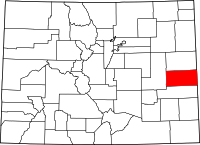 | |
| Unincorporated communities | ||