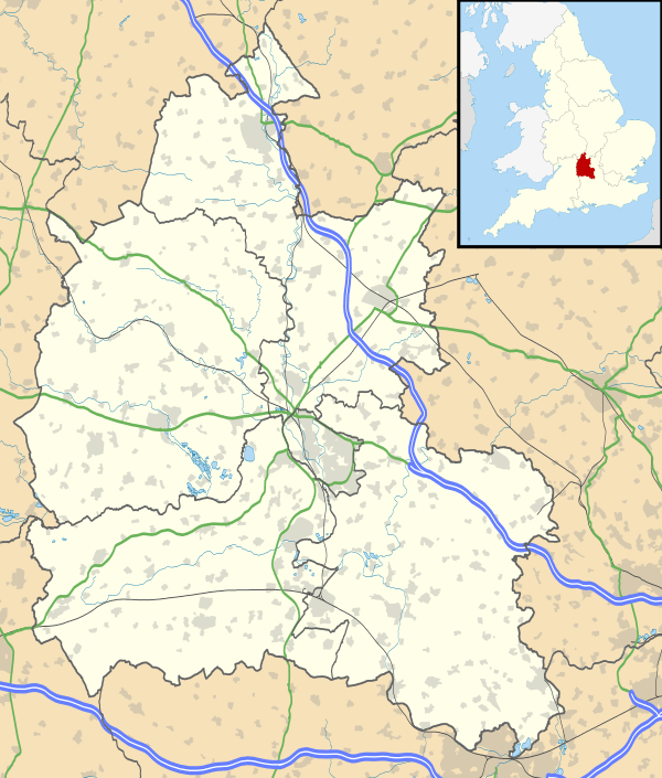
Ardley, Oxfordshire
| Ardley | |
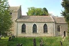 St. Mary's parish church |
|
 Ardley |
|
| Area | 8.79 km2 (3.39 sq mi) |
|---|---|
| Population | 751 (both for parish, with Fewcott) (2011 Census) |
| – density | 85/km2 (220/sq mi) |
| OS grid reference | SP5427 |
| Civil parish | Ardley |
| District | Cherwell |
| Shire county | Oxfordshire |
| Region | South East |
| Country | England |
| Sovereign state | United Kingdom |
| Post town | Banbury |
| Postcode district | OX27 |
| Dialling code | 01869 |
| Police | Thames Valley |
| Fire | Oxfordshire |
| Ambulance | South Central |
| EU Parliament | South East England |
| UK Parliament | Banbury |
|
|
Coordinates: 51°56′N 1°13′W / 51.94°N 1.21°W
Ardley is a village in Ardley with Fewcott civil parish in Oxfordshire, England, about 4 miles (6.4 km) northwest of Bicester.
The parish includes the village of Fewcott that is now contiguous with Ardley. The two villages are either side of a stream that rises at Fritwell, flows south to Ardley, then turns east through Stoke Lyne to Fringford. There it joins Crowell Brook, which continues east into Buckinghamshire and ultimately becomes part of the Great Ouse.
The 2011 Census recorded the population of Ardley and Fewcott parish as 751.[1]
Natural history
The limestone quarry at Ardley has yielded a significant find of dinosaur tracks (ichnites), discovered in 1997 and thought to have been left by Megalosaurus and possibly Cetiosaurus.
There is a site of special scientific interest in the village with a colony of the great crested newts and an outcrop of Jurassic limestone.
Castle
Ardley Castle is a motte-and-bailey which is believed to have been built early in the 12th century during the civil war between Empress Matilda and King Stephen.
Parish church
The Church of England parish church of Saint Mary dates from at least 1074.[2] The original church was demolished and completely rebuilt, but both the chancel and the bell tower of the present building contain small amounts of re-used Norman stonework. The present Early English Gothic chancel was built late in the 12th or early in the 13th century. The tower has a saddleback roof and may have been built in the 13th or 14th century. The present nave was built in 1793 and has a west gallery that was added in 1834.[3]
St Mary's is now part of the Benefice of Cherwell Valley, along with the parishes of Fritwell, Lower Heyford, Somerton, Souldern and Upper Heyford.[4]
The canal engineer Samuel Simcock (1727–1804) and his wife Esther (1720–1808), a sister of James Brindley, are buried at St Mary's.[5]
Economic history
In 1910 the Great Western Railway completed a new main line linking Ashendon Junction and Aynho Junction to shorten the high-speed route between its termini at London Paddington and Birmingham Snow Hill. The line passes within a few hundred yards of Ardley and the GWR opened a railway station on the main road just south of the village. British Railways closed Ardley railway station in 1963. The railway remains open and is now part of the Chiltern Main Line.
In 1990 the section of the M40 motorway between Wheatley, Oxfordshire and Hockley Heath was built. M40 Junction 10 with the A43 road is about 550 yards (500 m) northeast of Ardley and its Cherwell Valley services are about 1,100 yards (1 km) from the village.
Amenities

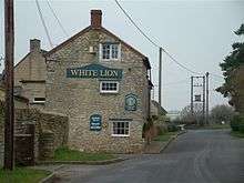
Ardley has a public house, the Fox and Hounds. Fewcott also has a pub, the White Lion Inn.
The village has no shops. Those at Cherwell Valley services are the nearest to the village.
Ardley United Football Club[6] is a Non-League football club whose first team plays its home games at The Playing Fields. Its first team is in the FTL Futbol Hellenic League Premier Division.[7]
References
- ↑ "Area: Ardley (Parish): Key Figures for 2011 Census: Key Statistics". Neighbourhood Statistics. Office for National Statistics. Retrieved 10 August 2015.
- ↑ Lobel, Mary D, ed. (1959). A History of the County of Oxford. Victoria County History. 6: Ploughley Hundred. London: Oxford University Press for the Institute of Historical Research. pp. 7–14.
- ↑ Sherwood, Jennifer; Pevsner, Nikolaus (1974). Oxfordshire. The Buildings of England. Harmondsworth: Penguin Books. pp. 422–423. ISBN 0-14-071045-0.
- ↑ Archbishops' Council (2010). "Benefice of Cherwell Valley". A Church Near You. Church of England. Retrieved 10 August 2015.
- ↑ Lewis, Christopher (2011). The Canal Pioneers, Brindley's School of Engineers. Brimscombe Port: The History Press. p. 136. ISBN 978-0-7524-6166-3.
- ↑ Ardley United FC
- ↑ "Premier Division". FTL Futbol Hellenic League. Retrieved 10 August 2015.
External links
| Wikimedia Commons has media related to Ardley. |
- Ardley in the Domesday Book
