Kut Chum District
| Kut Chum กุดชุม | |
|---|---|
| Amphoe | |
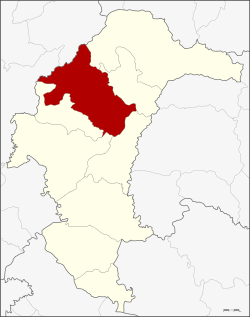 Amphoe location in Yasothon Province | |
| Coordinates: 16°2′0″N 104°20′17″E / 16.03333°N 104.33806°ECoordinates: 16°2′0″N 104°20′17″E / 16.03333°N 104.33806°E | |
| Country |
|
| Province | Yasothon |
| Seat | Kut Chum |
| Area | |
| • Total | 544.0 km2 (210.0 sq mi) |
| Population (2005) | |
| • Total | 65,959 |
| • Density | 121.25/km2 (314.0/sq mi) |
| Time zone | THA (UTC+7) |
| Postal code | 35140 |
| Geocode | 3503 |
Kut Chum (Thai: กุดชุม, pronounced [kùt t͡ɕʰūm]) is a district (amphoe) of Yasothon Province in northeastern Thailand.
History
The village of Kut Chum was established in 1912. A minor district (king amphoe) Kut Chum was established on August 1, 1961. It was made out of the four subdistricts Non Pueai, Phai (in 1978 reassigned to Sai Mun district), Phon Ngan and Kammaet split off from Yasothon district.[1]
On July 17, 1963, it was elevated to the level of district (amphoe), then of Ubon Ratchathani Province.[2] When Yasothon was separated from Ubon, Kut Chum was one of the districts relocated to the new province.
Geography
Neighboring districts are (from the northeast clockwise) Loeng Nok Tha, Thai Charoen, Pa Tio, Mueang Yasothon, and Sai Mun of Yasothon Province, and Selaphum and Nong Phok of Roi Et Province.
Economy
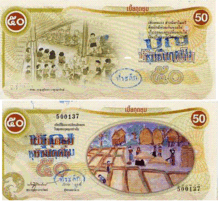
Kut Chum is well known for its organic movement and organic foods, chiefly the organic farming of rice.[3] Kut Chum also achieved fame for issuing its own local scrip called Bia Kut Chum. Bia, Thai for cowry shell, was once a unit of currency equal to 1⁄6400 of a Thai baht, and Bia is still current in metaphorical expressions, so the usage ran afoul of currency laws. To side-step implications that they intended a substitute local currency, they changed to Boon Kut Chum, which are barter coupons with a fixed value in baht, that may be exchanged for goods and services within the community.[4])
Primary occupations
- Rice farming
- Animal husbandry
- Crop farming
Secondary occupations
- Commerce
- Home-based businesses
Important products
Administration
The district is subdivided into 9 subdistricts (tambon) which make up 125 villages (muban).
|
|
District office
The district office of Kut Chum is located at
- Mu 8
- T. Kut Chum
- A. Kut Chum
- Yasothon 35140
Local administration
Kut Chum Phatthana is a subdistrict municipality (thesaban tambon) which covers parts of the subdistricts Kut Chum and Non Pueai. There are further 9 Tambon administrative organizations (TAO), one for each subdistrict covering the non-municipal areas.
Schools
The secondary schools in Amphoe Kut Chum are:
- Kut Chum Witthayakhom School (โรงเรียนกุดชุมวิทยาคม)
- Kam Maet Khanti Tham School (โรงเรียนกำแมดขันติธรรม)
- Phon Ngam Phiyakhan School (โรงเรียนโพนงามพิยาคาร)
References
- ↑ ประกาศกระทรวงมหาดไทย เรื่อง ยกฐานะตำบลขึ้นเป็นกิ่งอำเภอ (PDF). Royal Gazette (in Thai). 78 (63 ง): 1822. 1961-08-15.
- ↑ พระราชกฤษฎีกาตั้งอำเภอบ่อพลอย อำเภอไทรโยค อำเภอหนองเรือ อำเภอหนองสองห้อง อำเภอประทาย อำเภอห้วยแถลง อำเภอละหานทราย อำเภอกุยบุรี อำเภอตาพระยา อำเภอหนองไผ่ อำเภอนาเชือก อำเภอวัดเพลง อำเภอพนัสนิคม อำเภอภูกระดึง อำเภอปรางค์กู่ อำเภอท่าช้าง อำเภอบ้านด่านลานหอย อำเภอบ้านดง อำเภอสว่างอารมณ์ และอำเภอกุดชุม พ.ศ. ๒๕๐๖ (PDF). Royal Gazette (in Thai). 80 (72 ก): 362. 1963-07-16.
- ↑ http://ird.sut.ac.th/NRCT%20CDROM/xml/bx5035.xml
- ↑ A Boon to Kut Chum (Archived 2013-05-04 at WebCite)
External links
- amphoe.com (Thai)