Sawyers Bar, California
| Sawyers Bar | |
|---|---|
| unincorporated community place | |
 | |
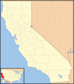 Sawyers Bar  Sawyers Bar Location in California | |
| Coordinates: 41°17′50.64″N 123°7′49.08″W / 41.2974000°N 123.1303000°W | |
| Country | United States |
| State | California |
| County | Siskiyou County |
| Elevation[1] | 2,247 ft (685 m) |
Sawyers Bar is an unincorporated community located on the North Fork Salmon River in unincorporated Siskiyou County, California, not to be confused with a Sawyers or Lawyers Bar in Del Norte County.[2]
History
Sawyers Bar, now in Siskiyou County was a California Gold Rush mining camp, first in Trinity County (one of the original counties of California, created in 1850 at the time of statehood). Then following the rush to the Klamath and Salmon Rivers, it became part of the now defunct Klamath County from 1851 to 1874. It was then within that part of Klamath County annexed to Siskiyou County. Sawyers Bar, was one of the largest gold producers in the county that year, along with Negro Flat, Gullion's Bar and Bestville.[3]
See also
- Bestville, California
-
 California portal
References
- ↑ U.S. Geological Survey Geographic Names Information System: Sawyers Bar, California
- ↑ GNIS Feature Detail Report for: Sawyers Bar
- ↑ Hubert Howe Bancroft, History of California, Vol. VI, 1848-1859, The History company, San Francisco, 1888, p.370
Coordinates: 41°17′51″N 123°07′49″W / 41.2974°N 123.1303°W
Municipalities and communities of Siskiyou County, California, United States | ||
|---|---|---|
| Cities |  | |
| CDPs | ||
| Unincorporated communities | ||
| Indian reservation | ||
| Ghost towns | ||
| Footnotes | ‡This populated place also has portions in an adjacent county or counties | |