Zwölferkogel (Stubai Alps)
| Zwölferkogel | |
|---|---|
|
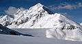
The Zwölferkogel from the northeast | |
| Highest point | |
| Elevation | 2,988 m (AA) (9,803 ft) |
| Isolation | 0.8 km → Sulzkogel |
| Coordinates | 47°11′24″N 11°00′37″E / 47.19°N 11.01028°ECoordinates: 47°11′24″N 11°00′37″E / 47.19°N 11.01028°E |
| Geography | |
| State/Province | AT-7 |
| Parent range | Stubai Alps |
| Geology | |
| Mountain type |
Gneiss rock summit |
| Climbing | |
| Normal route | From Kühtai through the Finstertal valley up the southeast flank or along the Langental valley and via the Zwölferkar cirque[1] |
.jpg)
The Zwölferkogel is a mountain, 2,988 m (AA), in the Stubai Alps in the Austrian state of Tyrol.
Topography
The Zwölferkogel lies about 2.7 kilometres south of the winter sport resort of Kühtai. The northwest face of the Zwölferkogel falls around 500 metres into the Längental valley. To the east below the Finstertal is the Finstertalspeicher, a reservoir belonging to the Sellrain-Silz Power Station. To the south, along a sharp arête, are the Mittagsköpfe (2,934 m (AA)), the Mittagsturm tower (2,929 m (AA)) and the Sulzkogel (3,016 m (AA)).
Gallery
 The Zwölferkogel behind the dam wall of the Finstertalspeicher
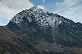 The Zwölferkogel
References
- ↑ bergsteigen.com: Zwölferkogel via the Zwölferkar
External links
| Wikimedia Commons has media related to Zwölferkogel. |
This article is issued from Wikipedia - version of the 2/16/2016. The text is available under the Creative Commons Attribution/Share Alike but additional terms may apply for the media files.