White Chuck Glacier
| White Chuck Glacier | |
|---|---|
|
Northern lobe of White Chuck Glacier as seen in 1973 | |
 White Chuck Glacier | |
| Type | Mountain glacier |
| Coordinates | 48°03′53″N 121°06′57″W / 48.06472°N 121.11583°WCoordinates: 48°03′53″N 121°06′57″W / 48.06472°N 121.11583°W[1] |
| Area | .54 sq mi (1.4 km2) in 2005 |
| Length | .75 mi (1.21 km) |
| Terminus | Icefall/Barren Rock |
| Status | Retreating |
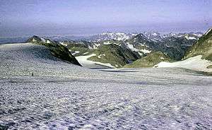
White Chuck Glacier is located in the Glacier Peak Wilderness in the U.S. state of Washington and is 3.5 mi (5.6 km) south of Glacier Peak. The glacier is within Mount Baker-Snoqualmie National Forest and nearly touches the White River Glacier though they are separated by an arête off the Kololo Peaks.[2] White Chuck Glacier has retreated significantly since the end of the Little Ice Age. From about 1850 to 1930, the glacier thinned and by 1940, a fast rate of retreat commenced. By 1955, the glacier had three separate termini and by 2005, the northern terminus was gone. Several small proglacial lakes have been left behind by the retreating glacier. Between 1958 and 2005 White Chuck Glacier lost more than half its surface area.[3]
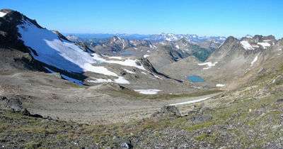
Same vantage point as at right above, in this 2006 image the northern lobe has disappeared
See also
References
- ↑ "White Chuck Glacier". Geographic Names Information System. United States Geological Survey. Retrieved 2012-11-30.
- ↑ Glacier Peak East, WA (Map). TopoQwest (United States Geological Survey Maps). Retrieved 2012-11-30.
- ↑ Pelto, Mauri (2007). "Glacier Peak A Century Of Change". North Cascade Glacier Climate Project. Nichols College. Retrieved 2012-11-30.
This article is issued from Wikipedia - version of the 6/2/2016. The text is available under the Creative Commons Attribution/Share Alike but additional terms may apply for the media files.