Walapane
| Walapane වලපනේ வலபனை | |
|---|---|
| Town | |
|
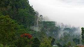
View from Walapane. | |
| Country |
|
| Admitted | ?? |
| Division | Walapane |
| Former seat | Walapane |
| Area | |
| • Total | 320 km2 (120 sq mi) |
| Gross Regional Product (2010)[1] | |
| • Total | Rs 465 billion |
| • Rank | 4th (9.6% of total) |
| Time zone | Sri Lanka (UTC+05:30) |
| ISO 3166 code | LK-23 |
| Official Languages | Sinhala, Tamil, English |
| Website | |

Walapane is located in Nuwara Eliya District of Sri Lanka. It is a high country area with lots of green mountains. The location of the Walapane area can be identify from Latitude: 7.095404, Longitude: 80.861671. It was called Wathtumulla in the past. The name Watumulla derived from the former tea factory which was located in the heart of the Walapane town and now demolished since the production of Wattumulla Plantation declined.[2] Walapane is administrated by the government of *Sri Lanka through *Walapane Divisional Secretariat.
History
Walapane was a division controlled by ancient Kandy Kingdom.
Geography
The province has an area of 320 km², a population of 103,152.
Climate
The climate is cool, Walapane is located above 1280 metres above sea level, often have chilly nights. Some slopes are very wet, some places having almost 7000 mm of rain per year. Some slopes are parts of the mid-dry zone as it is receiving rain only from North-Eastern monsoon. The Temperatures range from 24 °C to just 16 °C in Walapane. The highest mountains in Walapane is. The terrain is mostly mountainous, with deep valleys cutting into it. The two main mountain regions are the Pidurutalagala range.
Demographics
The population is a mixture of Sinhalese, Tamil and the Moors. Many tea plantation workers are Indian Tamils, brought over to Sri Lanka by the British in the 19th century.
Ethnicity
| Ethnic group | Population | % |
|---|---|---|
| Sinhala | ||
| Indian Tamil | ||
| Sri Lankan Moor | ||
| Sri Lankan Tamil | ||
| Burger | ||
| other | ||
| Total |
Administrative divisions
Divisional Secretariats
The districts of the Sri Lanka are divided into administrative sub-units known as divisional secretariats. These were originally based on the feudal counties, the korales and ratas. They were formerly known as 'D.R.O. Divisions' after the 'Divisional Revenue Officer'. Later the D.R.O.s became 'Assistant Government Agents' and the Divisions were known as 'A.G.A. Divisions'. Currently, the Divisions are administered by a 'Divisional Secretary', and are known as a 'D.S. Divisions'.
There are 36 divisional secretariats divided in Central Province, which are listed below, by district. There are 20 in Kandy District, 11 in Matale District and 5 in Nuwara Eliya District.
Villages of Walapane
- Mahauwa
- Egodakanda
- Harasbedda
- Kumbalgamuwa
- Manelwala
- Rupaha
- Karandagolla
- Rasingolla
- Kumbukwella
- Udamadura
- Teripaha
- Madulla
- weralla
- napala
- Diggala
Small Towns
- Walapane
- Ragala
- Nildandahinna
- Padiyapelella
- Udapussallawa
See also
| Wikimedia Commons has media related to Walapane. |
References
- ↑ ":.News Line : North, East record highest GDP growth rate". Priu.gov.lk. 2010-07-19. Retrieved 2014-02-01.
- ↑ http://www.auditorgeneral.gov.lk/web/upload/Walapane%20%20%20Pradeshiya%20Sabha%20-%20English.pdf
- "Walapane – The Place To Visit In Nuwara Eliya". alapane.com. Retrieved 16 January 2014.
Maps
External links
| Wikimedia Commons has media related to Walapane. |
- Central Provincial Council Sri Lanka
- Central Provincial Postal Codes Sri Lanka
- Cities in Central province
- "Walapane – The Place To Visit In Nuwara Eliya". alapane.com. Retrieved 16 January 2014.


Coordinates: 7°20′N 80°45′E / 7.333°N 80.750°E