Varel
| Varel | ||
|---|---|---|
|
Pedestrian area in Varel | ||
| ||
 Varel | ||
Location of Varel within Friesland district 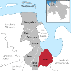
 | ||
| Coordinates: 53°23′49″N 08°08′10″E / 53.39694°N 8.13611°ECoordinates: 53°23′49″N 08°08′10″E / 53.39694°N 8.13611°E | ||
| Country | Germany | |
| State | Lower Saxony | |
| District | Friesland | |
| Government | ||
| • Mayor | Gerd-Christian Wagner (SPD) | |
| Area | ||
| • Total | 113.53 km2 (43.83 sq mi) | |
| Population (2015-12-31)[1] | ||
| • Total | 23,884 | |
| • Density | 210/km2 (540/sq mi) | |
| Time zone | CET/CEST (UTC+1/+2) | |
| Postal codes | 26316 | |
| Dialling codes | 04451 | |
| Vehicle registration | FRI | |
| Website | www.varel.de | |


Varel ([ˈfaːʁəl]) is a town in the district of Friesland, in Lower Saxony, Germany. It is situated near the Jade River and the Jade Bight, approximately 15 kilometres (9.3 mi) south of Wilhelmshaven and 30 kilometres (19 mi) north of Oldenburg.
Castle church
The castle church is the oldest building in Varel. The first part of the church is believed to have been built in 1144.[2] The tower was added between 1200 and 1250, originally as twin towers, which were rebuilt in today's form first in 1651 and then in 1737. The altar, font and pulpit were carved in 1613 – 1618 by Ludwig Münstermann. The altar is nearly 10 metres (33 ft) high and is one of the main works of Northern German Mannerism.
Before the Protestant Reformation, the patron saint was Saint Peter. Today, the castle church is a Lutheran church, with no patron saint. The church was formerly one of the buildings of the castle, which was demolished in the 19th century soon after a fire destroyed most parts of it.
Notable natives
- Hildegard Behrens (1937–2009), dramatic soprano
- Heiko Daxl (born 1957)
- Erich Heckel (1883-1979), painter
- Massiv in Mensch
- Karl Schmidt-Rottluff
- Lothar Meyer (1830–1895), chemist
- Johann Gerhard Oncken (1800–1884), Baptist preacher
- Carl Carls (1880–1958), chess master
- Friedrich Wegener (1907–1990)
- Hans-Paul Bürkner (born 1951), CEO of the Boston Consulting Group
- Markus Eichler (born 1982), cyclist
- Charlotte Sophie Bentinck (1715-1800), confidante Voltaire & . Frederick the Great
- Johann Gerhard Oncken (1800-1884), founder of the German and continental European Baptist churches
- Lothar Meyer (1830-1895) developed about the same time and independent of Dmitri Mendeleev modern periodic table of the elements
- Oskar Emil Meyer (1834-1909), German physicist
- Wilhelm Hegeler (1870-1943), writer
- Carl Carls (1880-1958), German chess champion
- Friedrich Wegener (1907-1990), German pathologist
- Hildegard Behrens (1937-2009), singer (soprano)
- Ines Varenkamp (born 1963), cyclist
International relations
Varel is twinned with:
References
External links
| Wikimedia Commons has media related to Varel. |
| Wikivoyage has a travel guide for Varel. |
- Official site (German)
Towns and municipalities in Friesland (district) | ||
|---|---|---|