Untere Wildgrubenspitze
| Untere Wildgrubenspitze | |
|---|---|
|
The Untere Wildgrubenspitze (far left) and Roggalspitze (2,673 m) | |
| Highest point | |
| Elevation | 2,753 m (AA) (9,032 ft) |
| Prominence | 2,753-1,773 m ↓ Flexen Pass |
| Isolation | 6.6 km → Valluga |
| Coordinates | 47°09′53″N 10°07′34″E / 47.1648278°N 10.1261556°ECoordinates: 47°09′53″N 10°07′34″E / 47.1648278°N 10.1261556°E |
| Geography | |
 Untere Wildgrubenspitze | |
| Parent range | Lechquellen Mountains |
| Geology | |
| Age of rock | Upper Carnian - Norian |
| Mountain type | Main dolomite |
| Climbing | |
| First ascent | 1877 by Andreas Madlener (tourist) |
| Normal route | From Zürsersee, ascent protected |
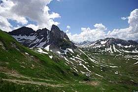
The Untere Wildgrubenspitze (rarely Große Wildgrubenspitze) is the highest peak of the Lechquellen Mountains in Austria. It reaches a height of 2,753 m (AA) and is located west of the ski resort of Zürs.
The summit may be reached from the Ravensburger Hut via the Schneegrube, Nadelscharte and southwest arête. This involves grade II to III climbing. The ascent from the northern side, from the Zürsersee is easier and protected with wire cables.
Around a kilometre north is the Obere Wildgrubenspitze with a height of 2,625 m (AA).
External links
| Wikimedia Commons has media related to Untere Wildgrubenspitze. |
This article is issued from Wikipedia - version of the 12/20/2015. The text is available under the Creative Commons Attribution/Share Alike but additional terms may apply for the media files.