Uisge Ban Falls
| Uisge Ban Waterfall | |
|---|---|
 | |
| Location | Uisge Ban Falls Provincial Park, New Glen, Nova Scotia, Canada |
| Coordinates | 46°12′48.55″N 60°47′31.31″W / 46.2134861°N 60.7920306°WCoordinates: 46°12′48.55″N 60°47′31.31″W / 46.2134861°N 60.7920306°W |
| Type | Cascade |
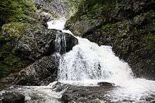
Uisge Ban Falls (Official Spelling "Easach Ban"[1] alternative spellings 'Uisage'; 'Bàn' or 'Bahn')[2] is a waterfall near Baddeck, Nova Scotia, Canada.
The name
The name Uisge Ban comes from the Gaelic meaning “white water”, uisge bàn, probably conflated with the word eas meaning a waterfall.
The official name usage for the falls is confusing as most maps produced by the Government of the Province of Nova Scotia and by many tourist groups use either of the two spellings starting with a "U", sometimes using both spellings in the same document, yet the only official name that appears in either Government of Nova Scotia or Government of Canada, Canadian Geographical Names Data Base (CGNDB) is the "Easach Ban" spelling. The "Easach Ban" spelling is the only version used on Government of Canada topographical maps.
Description
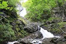
The falls is located in Uisge Ban Falls Provincial Park[3] near New Glen, Victoria County, 14.5 kilometres (9 miles) north of Baddeck.
The 16 m (50 ft.) high waterfall is accessible by trail. The Falls Trail is approximately 3.0 kilometres (1.8 miles) in length (round trip), and requires about one hour to complete. The trail passes through a field then follows Falls Brook upstream through a mixed forest and then a climax hardwood forest composed largely of maple, birch, and beech. The deep stream valley narrows dramatically in the vicinity of Uisge Ban Waterfall. At the falls, the sheer walls of the gorge tower 150 metres (500 feet) on either side.
Another trail in the park, the River Trail, proceeds north from Falls Brook. It is about 3.0 kilometres (1.8 miles) in length (return) and requires about one hour to travel. Following along the banks of the North Branch Baddeck River, the trail winds through a climax sugar maple, yellow birch, and beech forest at the foot of the river valley’s steep slope.
The original trail was developed with assistance from the Nova Scotia Forest Technicians Association. Recent improvements were undertaken by Stora Enso and the Nova Scotia Department of Natural Resources.
References
- ↑ Geographical Names of Canada - Easach Ban
- ↑ "Provincial Hiking Trails of Victoria County, Cape Breton Island" (PDF). Nova Scotia Natural Resources. Retrieved March 7, 2012.
- ↑ "Map of: Uisge Ban Falls Provincial Park". Nova Scotia Health Promotion and Protection. Retrieved March 7, 2012.
External links
- Nova Scotia Geographical Names (listed as Easach Ban - links to a detailed topo map)
- Uisge Ban Falls - Moosebait.com