Torridal
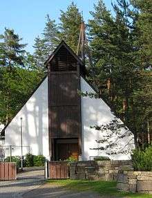
Torridal is a V-shaped valley and a part of the former Oddernes municipality and includes areas north of the city center of Kristiansand, Norway on both riverbanks of the river Otra. The local name Torridalselva (meaning Torridal river) is for the river's lower course. The areas and farm names Skråstad, Lian, Hagen and Glattetre on the east side of the river and Strai, Hommeren, Augland, Mosby and Høie on the west side belongs to Torridal in addition to the districts Espestøl, Hemmes, Mestad, Aurebekk, Rypestøl and Kulia.[1] Dense blocks around Mosby Station with 2,032 inhabitants is located in Kristiansand municipality is the southernmost part of the settlement Vennesla, while the Outer, Upper and Lower Strai is a separate village, Strai with 1627 inhabitants. Torridal sporting venue has facilities outdoors and indoors in Torridalshallen. Torridal Church and Cemetery was consecrated in 1978. Norwegian National Road 9 (Setesdalsveien) and Sørlandet Line (Sørlandsbanen) runs along the west side of Otra, through Torridal.
References
- ↑ About Torridal Torridal Historielag (Norwegian)
Coordinates: 58°12′15″N 7°55′44″E / 58.20417°N 7.92889°E