Thanamandi
| Thanamandi | |
|---|---|
| city | |
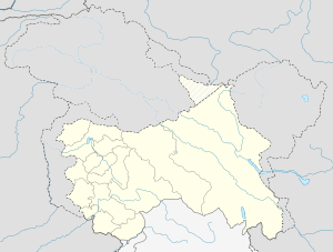 Thanamandi  Thanamandi Location in Jammu and Kashmir, India | |
| Coordinates: 33°33′N 74°23′E / 33.55°N 74.38°ECoordinates: 33°33′N 74°23′E / 33.55°N 74.38°E | |
| Country |
|
| State | Jammu and Kashmir |
| District | Rajouri |
| Elevation | 1,725 m (5,659 ft) |
| Population (2011) | |
| • Total | 7,204 |
| Languages | |
| • Official | Urdu |
| Time zone | IST (UTC+5:30) |
Thanamandi is a town and a municipal committee in Rajouri district in the Indian state of Jammu and Kashmir.ThannaMandi lies on Mughal Road.The town is sacred for the people as it is home to the most important Sufi saint Baba Ghulam Shah Budshah. The place called Shahdara Sharief houses the mausoleum of Babaji in the town.
Geography
Thanamandi is located at 33°33′N 74°23′E / 33.55°N 74.38°E.[1] It has an average elevation of 1,478 metres (5,659 feet).
Demographics
As of 2011 India census,[2] Thanamandi had a population of 7,204. Males constitute 53% of the population and females 47%. Thanna Mandi has an average literacy rate of 60%, higher than the national average of 59.5%: male literacy is 69%, and female literacy is 49%. In Thanamandi, 12% of the population is under 6 years of age. This region is home to several villages of mixed tribes including gujjars, kamalaks, khans, kashmiris including Dars (converted from poshnaries), Bhats (converted from kasbies), Mir (converted from marag bans), shawls, Najjars( converted to Raina and wani) Dooms (converted to thakars), and samyals.This town is about 7 km from Shadhara shrief which is famous for chikri wood craft. Most of the families in the town are kashmiri in tribes beside with some population of Gujjars and rajputs. The entire town of the Thanna Mandi is a mixed population of different communities having origin from Kashmir Valley since 1505 BC. They have converted to Islam from kashmiri pandits ( Brahmans) and have opted different trades and skills to catch the livelihood options. From the town of Thanna Mandi to district headquarters(Rajouri) its only 23 km. Thanna Mandi has also strategic importance as it falls on the way to Srinagar through Mughal road. During off season People/ used to walk over Peerpanjal range a short-cut route to Srinagar in search of food for their cattle's. After Mughal road is constructed this has become an alternate route to reach Srinagar for vehicles. Town still has some old forts been built at the time of Mughals. People say it used to be a trade market during Mughal time so the name came 'Mandi'.
References
- ↑ Falling Rain Genomics, Inc - Thanamandi
- ↑ "Census of India 2001: Data from the 2001 Census, including cities, villages and towns (Provisional)". Census Commission of India. Archived from the original on 2004-06-16. Retrieved 2008-11-01.