Tamanrasset District
| Tamanrasset District دائرة تمنراست | |
|---|---|
| District | |
 Map of Tamanrasset District | |
| Coordinates: 22°47′N 5°31′E / 22.783°N 5.517°ECoordinates: 22°47′N 5°31′E / 22.783°N 5.517°E | |
| Country |
|
| Province | Tamanrasset |
| District seat | Tamanrasset |
| Area | |
| • Total | 131,151 km2 (50,638 sq mi) |
| Population (2008)[1] | |
| • Total | 96,843 |
| • Density | 0.74/km2 (1.9/sq mi) |
| Time zone | CET (UTC+01) |
| Municipalities | 2 |
Tamanrasset is a district in Tamanrasset Province, Algeria. It was named after its capital, Tamanrasset, which is also the capital of the province. With 96,843 people,[1] it is the most populated district in the province (however, the population density is low) and one of the largest districts in the country.
Municipalities
The district is further divided into 2 municipalities:[2]
References
- 1 2 "Population: Wilaya de Tamanrasset" (PDF) (in French). Office National des Statistiques Algérie. Retrieved 30 May 2013.
- ↑ "Décret executif n° 91-306 du 24 août 1991 fixant la liste des communes animées par cheque chef de daïra. Wilaya d'El Oued" (PDF) (in French). Journal officiel de la République Algérienne. 4 September 1991. p. 1299. Archived from the original (PDF) on 2 March 2013 or before. Retrieved 30 May 2013. Check date values in:
|archive-date=(help)
| Tamanrasset District | 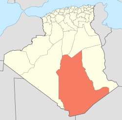 | |||||||
|---|---|---|---|---|---|---|---|---|
| In Salah District | ||||||||
| Tazrouk District | ||||||||
| Abalessa District | ||||||||
| In Ghar District | ||||||||
| Tin Zaouatine District | ||||||||
| In Guezzam District | ||||||||
This article is issued from Wikipedia - version of the 6/19/2016. The text is available under the Creative Commons Attribution/Share Alike but additional terms may apply for the media files.