Southern Peninsula (Iceland)
| Suðurnes | |
|---|---|
 The Suðurnes area | |
| Country | Iceland |
| Seat | Keflavík |
| Area | |
| • Total | 829 km2 (320 sq mi) |
| Population (2007) | |
| • Total | 20,300 |
| • Density | 24.5/km2 (63/sq mi) |
Southern Peninsula (Icelandic: Suðurnes) or Reykjanesskagi (pronounced [ˈreːicjanɛsskʰajI]) is a region in southwest Iceland. It was named after Reykjanes, the southwestern tip Reykjanesskagi. The region has a population of more than 22,000 and is one of the more densely populated parts of the island. The administrative centre is Keflavík, which had 7,000 residents when it merged with the nearby town of Njarðvík several years ago to create Reykjanesbær, which is the second largest settlement outside the Greater Reykjavík area; on 1 January 2013 the town had a population of 14,231.
The region is the location of Keflavík International Airport, the major point of entry for Iceland, and also the Blue Lagoon health spa.
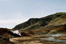
The peninsula is marked by active volcanism under its surface, and large lava fields, allowing little vegetation. There are numerous hot springs and sulphur springs in the southern half of the peninsula, around the Kleifarvatn lake and the Krýsuvík geothermal area.
There is also a geothermal power station at Svartsengi. Near the power station a swimming pool has been installed using the hot and mineralized water coming down from the power station; it is known as the "Blue Lagoon" (Bláa Lónið).
The Leif the Lucky (or Miðlína) Bridge spans the Álfagjá rift valley (60 feet wide and 20 feet (6.1 m) deep) near Grindavik, which marks the boundary of the Eurasian and North American continental tectonic plates. It was built in 2002 and named in honor of Icelandic explorer Leif Eriksson who traveled from Europe to America 500 years before Columbus.
Some fishing towns, such as Grindavík and Njarðvík are situated on the peninsula as well as the town of Keflavík, the site of Keflavík International Airport and the Leifur Eriksson Air Terminal and the former American military base.
Volcanic system
| Reykjanes (volcano) | |
|---|---|
%2C_Reykjanes_peninsula.JPG) The Reykjanes volcanic system is almost completely covered by Holocene-age lava fields. | |
| Highest point | |
| Elevation | 230 m (754 ft) |
| Coordinates | 63°52′12″N 22°33′30″W / 63.87000°N 22.55833°W |
| Geography | |
| Location | Reykjanes Peninsula, Iceland |
| Parent range | Mid-Atlantic Ridge |
| Geology | |
| Mountain type | Crater rows |
| Last eruption | 1926 |
The Reykjanes Volcano is a large volcano covering the Reykjanes Peninsula in Iceland, where the Mid-Atlantic Ridge rises above sea level. The volcanic system consists of lava fields, postglacial basaltic crater rows, and small shield volcanoes. The submarine Reykjaneshryggur volcanic system is contiguous and is considered part of the Reykjanes volcanic system, which is the westernmost of a series of four closely spaced en-echelon fissure systems they extend across the Reykjanes Peninsula. The highest of the system's multiple vents is 230 metres (754 ft). Dredging operations resulted in recovery of basaltic rocks of probable Holocene age. Most of the subaerial part of the system is covered by Holocene-age lava fields. During the 13th century, subaerial eruptions occurred on the fissure system along the Reykjanes fissure system. Tephra deposits from Holocene eruptions have been preserved on the Reykjanes Peninsula.
Gallery
 Leif the Lucky Bridge spanning the Álfagjá rift valley
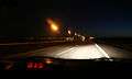 Route 41 between Keflavík and Njarðvík
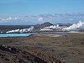 Reykjanesvirkjun geothermal power plant
%2C_Grindav%C3%ADk.JPG)
 Salt lake
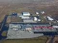 Keflavík International Airport
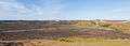 Valahnukur
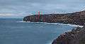 Holmbergs lighthouse
See also
External links
 Southwest Iceland travel guide from Wikivoyage
- Reykjanes
- Photography
- http://isafold.de/reykjavegur01/img_sveifluhals.htm
- http://isafold.de/reykjavegur01/img_pass.htm
- http://isafold.de/reykjavegur01/img_keilir.htm
- http://isafold.de/reykjavegur01/img_dampf.htm
- http://icelandiscool.com/photos/islandpictures.htm
Iceland articles | ||||||||
|---|---|---|---|---|---|---|---|---|
| History |
|  | ||||||
| Geography | ||||||||
| Politics | ||||||||
| Economy | ||||||||
| Society |
| |||||||
| ||||||||
Coordinates: 63°55′N 22°15′W / 63.917°N 22.250°W