South Kyme
| South Kyme | |
 South Kyme |
|
| Population | 393 (2011) |
|---|---|
| OS grid reference | TF175497 |
| – London | 110 mi (180 km) S |
| District | North Kesteven |
| Shire county | Lincolnshire |
| Region | East Midlands |
| Country | England |
| Sovereign state | United Kingdom |
| Post town | Lincoln |
| Postcode district | LN4 |
| Police | Lincolnshire |
| Fire | Lincolnshire |
| Ambulance | East Midlands |
| EU Parliament | East Midlands |
| UK Parliament | Sleaford and North Hykeham |
|
|
Coordinates: 53°01′56″N 0°14′56″W / 53.032120°N 0.2489°W
South Kyme is a small village and civil parish[1][2] in the North Kesteven district of Lincolnshire, England. The population of the civil parish at the 2011 census was 393.[3] It is located 2.5 miles (4 km) south-east from North Kyme which is itself 2.5 miles (4 km) from Billinghay.
South Kyme contains a public house, The Hume Arms, and a golf club.[4] The River Slea, which is called the 'Kyme Eau' from Ferry Farm a mile or so to the north of South Kyme, runs parallel to the main road, passing under three bridges, and eventually flowing into the River Witham at Chapel Hill.[5] The river was once navigable by the Sleaford Navigation from the Witham to the market town of Sleaford.
The South Kyme emblem is a Kingfisher, modelled as a wooden sculpture by Simon Todd.[6]
Landmarks
Kyme Priory
The church is dedicated to Saint Mary and All Saints and is a Grade II* listed building which dates from at least 1196 as the former Augustinian Kyme Priory. The church today consists of the south aisle and part of the nave of the former priory.[7][8]
Kyme Tower
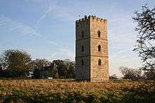
On a site to the west of the village stands the Grade I listed Kyme Tower for which the village is best known. This was a mediaeval castle which is believed to have been built between 1339 and 1381 by Gilbert de Umfraville third Earl of Angus and Lord of Kyme. Most of the building was demolished around 1720–1725 leaving only the single ashlar (stone block) tower.[9][10]
References
- ↑ "Parish Council web site". Retrieved 24 March 2011.
- ↑ "Parish council details". Retrieved 23 March 2011.
- ↑ "Civil Parish population 2011". Neighbourhood Statistics. Office for National Statistics. Retrieved 30 May 2016.
- ↑ Golf Club
- ↑ 261 Boston:Tattershall, Billinghay & Heckington (Map) (A1 ed.). 1:25 000. Explorer. OSGB. 3 April 2006. ISBN 978-0-319-23817-2. TF209540
- ↑ About Britain
- ↑ Historic England. "Monument No. 351030". PastScape. Retrieved 11 June 2011.
- ↑ "British Listed Buildings". St Mary & All Saints Church. English Heritage. Retrieved 11 June 2011.
- ↑ Historic England. "Kyme Tower (351033)". PastScape. Retrieved 24 March 2011.
- ↑ "British Listed Buildings". Kyme Tower. English Heritage. Retrieved 11 June 2011.
External links
 Media related to South Kyme at Wikimedia Commons
- "South Kyme Tourist Information"; Aboutbritain.com
- Village web site
- "South Kyme", Genuki
- Treasure Trove: South Kyme Tower, Lincsheritage.org
England Portal | |
| Unitary authorities | |
| Boroughs or districts | |
| Major settlements |
|
| Topics | |